Achill Island
Welcome to Achill Island, a Temperate island in the North Atlantic Ocean, part of the majestic Atlantic Ocean. This guide offers a comprehensive overview of what makes Achill Island unique – from its geography and climate to its population, infrastructure, and beyond. Dive into the details:
- Geography and Size: Explore the island’s size and location.
- Climate and Weather: Weather patterns and temperature.
- Topography and Nature: Uncover the natural wonders of the island.
- Infrastructure and Travelling: Insights on reaching, staying, and making the most of your visit.
- News and Headlines: Latest News.
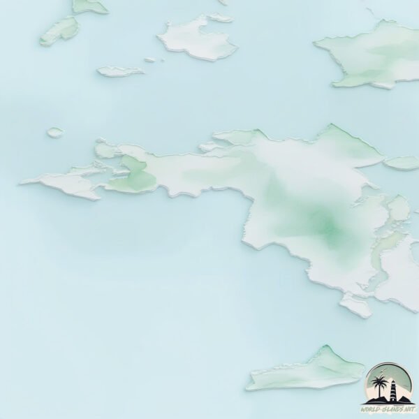
Geography and size of Achill Island
Size: 149.4 km²
Coastline: 124.3 km
Ocean: Atlantic Ocean
Sea: North Atlantic Ocean
Continent: Europe
Achill Island is a Large Island spanning 149 km² with a coastline of 124 km.
Archipel: British Isles – A group of islands off the northwest coast of mainland Europe, including Great Britain, Ireland, and over 6,000 smaller islands, known for their rich history and cultural diversity.
Tectonic Plate: Eurasia – One of the world’s largest tectonic plates, the Eurasian Plate covers a significant portion of Europe and Asia. It’s characterized by diverse geological features, including the Ural Mountains, the European Plain, and the Himalayas formed from its collision with the Indian Plate.
The geographic heart of the island is pinpointed at these coordinates:
Latitude: 53.96573505 / Longitude: -10.03519086
Climate and weather of Achill Island
Climate Zone: Temperate
Climate Details: Temperate Oceanic Climate
Temperature: Warm Summer
Climate Characteristics: Known for its moderate year-round temperatures with ample rainfall and no dry season. Warm summers are characteristic.
Topography and nature of Achill Island
Timezone: UTC±00:00
Timezone places: Europe/London
Max. Elevation: 525 m
Mean Elevation: 97 m
Vegetation: Agricultural Mosaic
Tree Coverage: 23%
The mean elevation is 97 m. The highest elevation on the island reaches approximately 525 meters above sea level. The island is characterized by Plateau: Elevated flatlands rising sharply above the surrounding area, with a maximum elevation over 500 meters but a mean elevation less than 300 meters, forming unique highland areas on islands.
Dominating Vegetation: Agricultural Mosaic
A mix of cropland and natural vegetation, often seen in rural landscapes where agricultural fields are interspersed with patches of natural habitats. Achill Island has a tree cover of 23 %.
Vegetation: 12 vegetation zones – Exceptionally Diverse Island
Islands with more than ten vegetation zones are among the most ecologically rich and varied in the world. These islands are akin to miniature continents, boasting an incredible array of ecosystems. The sheer range of habitats, from high peaks to deep valleys, rainforests to deserts, creates a mosaic of life that is unparalleled. They are crucial for conservation and ecological studies.
Infrastructure and Travelling to Achill Island
Does the island have a public airport? no.
There is no public and scheduled airport on Achill Island. The nearest airport is Connemara Regional Airport, located 89 km away.
Does the island have a major port? no.
There are no major ports on Achill Island. The closest major port is WESTPORT, approximately 46 km away.
The mean population of Achill Island is 17 per km². Achill Island is Gently Populated. The island belongs to Ireland.
The name of the island resonates across different cultures and languages. Here is how it is known around the world: Arabic: جزيرة أيرلندا; German: Irland; Spanish: Isla de Irlanda; French: Irlande; Portuguese: Irlanda; Russian: Ирландия; Chinese: 爱尔兰岛
Continuing your journey, Inishbofin is the next notable island, situated merely km away.
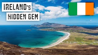
ACHILL ISLAND: Best Things To Do on Ireland's Hidden Gem | County Mayo Travel Guide


Ireland is classified as Developed region: nonG7: Developed economies outside of the Group of Seven, characterized by high income and advanced economic structures. The level of income is High income: OECD.
News – Latest Updates and Headlines from Achill Island
Stay informed with the most recent news and important headlines from Achill Island. Here’s a roundup of the latest developments.
Please note: The data used here has been primarily extracted from satellite readings. Deviations from exact values may occur, particularly regarding the height of elevations and population density. Land area and coastline measurements refer to average values at mean high tide.