St. Kitts

Welcome to St. Kitts, a Tropical island in the Caribbean Sea, part of the majestic Atlantic Ocean. This guide offers a comprehensive overview of what makes St. Kitts unique – from its geography and climate to its population, infrastructure, and beyond. Dive into the details:
- Geography and Size: Explore the island’s size and location.
- Climate and Weather: Weather patterns and temperature.
- Topography and Nature: Uncover the natural wonders of the island.
- Infrastructure and Travelling: Insights on reaching, staying, and making the most of your visit.
- News and Headlines: Latest News.
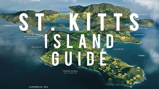
Geography and size of St. Kitts
Size: 168 km²
Coastline: 92.8 km
Ocean: Atlantic Ocean
Sea: Caribbean Sea
Continent: North America
St. Kitts is a Large Island spanning 168 km² with a coastline of 93 km.
Archipel: Lesser Antilles – A long arc of small islands in the Caribbean Sea, stretching from the Virgin Islands to Trinidad, known for their distinct cultures and tropical landscapes.
Tectonic Plate: Scotia – Situated in the Southern Ocean, surrounding the Scotia Sea, between South America and Antarctica, known for the Scotia Arc and active seismicity.
The geographic heart of the island is pinpointed at these coordinates:
Latitude: 17.34084411 / Longitude: -62.76684899
Climate and weather of St. Kitts
Climate Zone: Tropical
Climate Details: Tropical Monsoon Climate
Temperature: Hot
Climate Characteristics: Characterized by heavy rainfall, high humidity, and uniformly high temperatures, but with a distinct short dry season. It features a seasonal reversal of prevailing wind directions.
Topography and nature of St. Kitts
Timezone: UTC-04:00
Timezone places: America/La_Paz
Max. Elevation: 889 m
Mean Elevation: 212 m
Vegetation: Open Woodland
Tree Coverage: 44%
The mean elevation is 212 m. The highest elevation on the island reaches approximately 889 meters above sea level. The island is characterized by Plateau: Elevated flatlands rising sharply above the surrounding area, with a maximum elevation over 500 meters but a mean elevation less than 300 meters, forming unique highland areas on islands.
Dominating Vegetation: Open Woodland
Characterized by sparsely distributed trees with open canopy allowing sunlight to penetrate, supporting grasses and shrubs underneath. Often found in drier or transitional environments. St. Kitts has a tree cover of 44 %.
Vegetation: 14 vegetation zones – Exceptionally Diverse Island
Islands with more than ten vegetation zones are among the most ecologically rich and varied in the world. These islands are akin to miniature continents, boasting an incredible array of ecosystems. The sheer range of habitats, from high peaks to deep valleys, rainforests to deserts, creates a mosaic of life that is unparalleled. They are crucial for conservation and ecological studies.
Infrastructure and Travelling to St. Kitts
Does the island have a public airport? yes.
St. Kitts has a public and scheduled airport. The following airports are located on this island: Robert L. Bradshaw International Airport.
Does the island have a major port? yes.
St. Kitts is home to a major port. The following ports are situated on the island: BASSETERRE.
The mean population of St. Kitts is 252 per km². St. Kitts is Moderately Inhabited. The island belongs to Saint Kitts and Nevis.
The name of the island resonates across different cultures and languages. Here is how it is known around the world: Arabic: سانت كيتس; Spanish: Isla de San Cristóbal; French: Saint-Christophe; Portuguese: Ilha de São Cristóvão; Russian: Сент-Китс; Chinese: 圣基茨岛
Continuing your journey, Nevis is the next notable island, situated merely km away.
Best Things To Do in Saint Kitts & Nevis 2024 4K


Saint Kitts and Nevis is classified as Developing region: Regions characterized by lower income levels, with economies in the process of industrialization and modernization. The level of income is High income: nonOECD.
News – Latest Updates and Headlines from St. Kitts
Stay informed with the most recent news and important headlines from St. Kitts. Here’s a roundup of the latest developments.
Please note: The data used here has been primarily extracted from satellite readings. Deviations from exact values may occur, particularly regarding the height of elevations and population density. Land area and coastline measurements refer to average values at mean high tide.