Welcome to Andoya, a Continental island in the Norwegian Sea, part of the majestic Arctic Ocean. This guide offers a comprehensive overview of what makes Andoya unique – from its geography and climate to its population, infrastructure, and beyond. Dive into the details:
Geography and size of Andoya
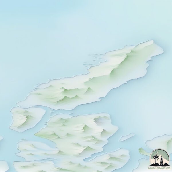
Size: 503.4 km²
Coastline: 227.3 km
Ocean: Arctic Ocean
Sea: Norwegian Sea
Continent: Europe
Andoya is a Large Island spanning 503 km² with a coastline of 227 km.
Archipel: Vesterålen – A district and archipelago in Norway, north of the Lofoten, known for its stunning landscapes, fishing culture, and whale watching.
Tectonic Plate: Eurasia – One of the world’s largest tectonic plates, the Eurasian Plate covers a significant portion of Europe and Asia. It’s characterized by diverse geological features, including the Ural Mountains, the European Plain, and the Himalayas formed from its collision with the Indian Plate.
The geographic heart of the island is pinpointed at these coordinates:
Latitude: 69.10568709 / Longitude: 15.79351927
Climate and weather of Andoya
Climate Zone: Continental
Climate Details: Subarctic Climate
Temperature: Cold Summer
Climate Characteristics: Characterized by long, extremely cold winters and short, cool summers, often found in northern latitudes of North America and Eurasia.
Topography and nature of Andoya
Timezone: UTC+01:00
Timezone places: Europe/Paris
Max. Elevation: 750 m
Mean Elevation: 137 m
Vegetation: Open Woodland
Tree Coverage: 26%
The mean elevation is 137 m. The highest elevation on the island reaches approximately 750 meters above sea level. The island is characterized by Plateau: Elevated flatlands rising sharply above the surrounding area, with a maximum elevation over 500 meters but a mean elevation less than 300 meters, forming unique highland areas on islands.
Dominating Vegetation: Open Woodland
Characterized by sparsely distributed trees with open canopy allowing sunlight to penetrate, supporting grasses and shrubs underneath. Often found in drier or transitional environments. Andoya has a tree cover of 26 %.
Vegetation: 9 vegetation zones – Very Highly Diverse Island
Islands in this range are ecological powerhouses, showcasing a wide array of vegetation zones. Each zone, from lush rainforests to arid scrublands, coastal mangroves to mountainous regions, contributes to a complex and interdependent ecosystem. These islands are often hotspots of biodiversity, supporting numerous species and intricate ecological processes.
Infrastructure and Travelling to Andoya
Does the island have a public airport? yes.
Andoya has a public and scheduled airport. The following airports are located on this island: Andøya Airport, Andenes.
Does the island have a major port? no.
There are no major ports on Andoya. The closest major port is ANDENES, approximately 1 km away.
The mean population of Andoya is 7 per km². Andoya is Gently Populated. The island belongs to Norway.
The name of the island resonates across different cultures and languages. Here is how it is known around the world: Arabic: فيستريلان; German: Vesterålen; Spanish: Vesterålen; French: Vesterålen; Portuguese: Vesterålen; Russian: Вестеролен; Chinese: 西奧倫群島
Continuing your journey, Hinnoya is the next notable island, situated merely km away.
This Hidden Norwegian Island Will Leave You Speechless 🌊🇳🇴
Discover the stunning beauty of Andøya — a hidden gem in Northern Norway. From dramatic coastal cliffs to peaceful fishing ...This Hidden Norwegian Island Will Leave You Speechless 🌊🇳🇴
Discover the stunning beauty of Andøya — a hidden gem in Northern ...
Discover the stunning beauty of Andøya — a hidden gem in Northern Norway. From dramatic coastal cliffs to peaceful fishing ...
Andøya islands best places✨️ #northeurope #norwaytravel #travel #roadtrip #europeanadventure
Børhella Lighthouse: A small but charming lighthouse where you can ...
Børhella Lighthouse: A small but charming lighthouse where you can climb up to enjoy stunning panoramic views. Its location ...
Andøya Scenic Drive – Norway’s Most Stunning Coastal Road
Experience one of Norway's most breathtaking drives – the Scenic Route ...
Experience one of Norway's most breathtaking drives – the Scenic Route on Andøya. This 58 km journey through the Vesterålen ...
Andoya, Norway: Watch Whales, Epic Hikes, Stunning Beaches, Wild Safaris, Fishing, Surfing, more
Andøya - Nord-Norges Kreta?
Kronekursen er på sitt laveste og renta er høy. Jeg er fri for jobb, ...
Kronekursen er på sitt laveste og renta er høy. Jeg er fri for jobb, og Sølvi er fri for jobb. Velkommen til sommerferie på Andøya.
LOFOTEN VS ANDØYA, NORWAY🇳🇴
Exploring Norway's Hidden Gems: Nordkapp to Andoya
Journey through Norway's stunning landscapes, from the iconic Nordkapp ...
Journey through Norway's stunning landscapes, from the iconic Nordkapp to the serene Andoya. Experience breathtaking ...
Måtind Trail on Andoya Island, Norway
Turquoise sea and pearly white sand in Andøya, Norway🏖🌊🇳🇴🏔 By IG:FrankDahl
Andøya has steep mountain sections that reach up to 700 meters in ...
Andøya has steep mountain sections that reach up to 700 meters in height. The highest point on the island is Kvasstinden at 705 ...
Isar Aerospace Spectrum crashes in Andoya, Norway!
Andoya, Norway #norway #explorenorway #norwayadventure #shorts
Andoya, Norway #norway #explorenorway #norwayadventure #shorts ...
Andoya, Norway #norway #explorenorway #norwayadventure #shorts Somewhere beyond the fjords, Norway tells her quiet ...
Bukkekjerka, Norwegian Scenic Route Andøya
At Børra, the road separates the steep mountainside in the east from ...
At Børra, the road separates the steep mountainside in the east from the open sea that breaks against the shore in the west.
FIRST WEEKS ON THE ISLAND ANDØYA | Life in Northern Norway #01
A couple of weeks ago we arrived in Northern Norway to start a life ...
A couple of weeks ago we arrived in Northern Norway to start a life close to nature and until so far I can say it's realy beautiful here ...
What to EXPECT on a Whale Safari | Andenes | Vesterålen
Experience the Whale Safari in Andenes, Norway in all year round! Join ...
Experience the Whale Safari in Andenes, Norway in all year round! Join Whalesafari Andenes, experts since 1989, on an ...
Life on the Arctic Island Andøya | Winter in Northern Norway #23
Here is a new video about our life on the island Andøya in Northern ...
Here is a new video about our life on the island Andøya in Northern Norway. I hope you have a great start to the new year!
Andøya, Norway: CRAZY winds of storm drag fully-grown man across icy ground || WooGlobe
It's not possible to fully grasp the concept of 'out of control' ...
It's not possible to fully grasp the concept of 'out of control' without watching this video first. Shared by Benjamin, this terrifyingly ...
PARADISE On Earth Norway 🇳🇴 Places To See In Norway 🇳🇴 Andøya
Andøya Island and the remote village of Bleik to see a colony of the illusive Puffins.
Island hopping in Norway, our next stop is Andøya and the remote ...
Island hopping in Norway, our next stop is Andøya and the remote village of Bleik to go see a colony of the illusive Puffins.
Arctic Circle Tiny House Andoya Norway
The cutest tiny house in Norway I am obsessed with tiny houses, so ...
The cutest tiny house in Norway I am obsessed with tiny houses, so @marmelkroken was a perfect stay for us. It is on the ...
Summer on the island Andøya | Life in Northern Norway #06
Right now we're in the middle of august and the weather is very rough ...
Right now we're in the middle of august and the weather is very rough A lot of heavy rainfall and hard wind. Here on the Island ...
The midnight Sun on the island of Andoya in Northern Norway Amazing
Friends! Subscribe to our channel !!! #Amazing #norway #norge ...
Friends! Subscribe to our channel !!! #Amazing #norway #norge #northernlights #aurora #visitnorway #night #bucketlist ...
Måtind hike in Norway | Andøya island's iconic hike | Short hike in Northern Norway
Try the hike to Måtind, the most famous trail on the island of Andøya, ...
Try the hike to Måtind, the most famous trail on the island of Andøya, Norway. See the wonderful landscape and the wild sea from ...
Andøya 😍 Norway #travel #lofotenislands #travelnorway #nature #drone #lofoten #mountain #norway
ANDØYA 🇧🇻 Stellplatzsuche & Karibikstrand in Norwegen | Vesterålen VLOG #93
Unser erster Tag in Norwegen führt uns durch eine atemberaubende ...
Unser erster Tag in Norwegen führt uns durch eine atemberaubende Landschaft. Wir fahren vom Festland aus auf die Vesterålen ...
Andøya - Norway (4K)
Captured with DJI Mavic Pro 2.
Captured with DJI Mavic Pro 2.
Norway is classified as Developed region: nonG7: Developed economies outside of the Group of Seven, characterized by high income and advanced economic structures. The level of income is High income: OECD.
News – Latest Updates and Headlines from Andoya
Stay informed with the most recent news and important headlines from Andoya. Here’s a roundup of the latest developments.
Loading...
Please note: The data used here has been primarily extracted from satellite readings. Deviations from exact values may occur, particularly regarding the height of elevations and population density. Land area and coastline measurements refer to average values at mean high tide.