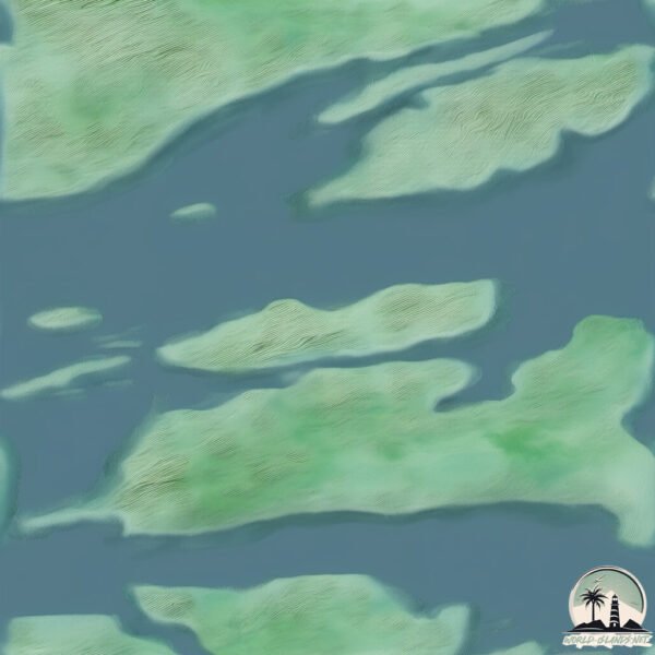
Welcome to Dolma, a Continental island in the Norwegian Sea, part of the majestic Arctic Ocean. This guide offers a comprehensive overview of what makes Dolma unique – from its geography and climate to its population, infrastructure, and beyond. Dive into the details:
Geography and size of Dolma
Size: 2.878 km²
Coastline: 9.1 km
Ocean: Arctic Ocean
Sea: Norwegian Sea
Continent: Europe
Dolma is a Small Island spanning 2.9 km² with a coastline of 9.1 km.
Archipel: –
Tectonic Plate: Eurasia – One of the world’s largest tectonic plates, the Eurasian Plate covers a significant portion of Europe and Asia. It’s characterized by diverse geological features, including the Ural Mountains, the European Plain, and the Himalayas formed from its collision with the Indian Plate.
The geographic heart of the island is pinpointed at these coordinates:
Latitude: 65.01559888 / Longitude: 11.65044491
Climate and weather of Dolma
Climate Zone: Continental
Climate Details: Warm-Summer Humid Continental Climate
Temperature: Warm Summer
Climate Characteristics: Features warm summers and cold winters with consistent precipitation, common in higher latitudes.
Topography and nature of Dolma
Timezone: UTC+01:00
Timezone places: Europe/Paris
Max. Elevation: 133 m
Mean Elevation: 83 m
Vegetation: Evergreen Needleleaf Forest
Tree Coverage: 75%
The mean elevation is 83 m. The highest elevation on the island reaches approximately 133 meters above sea level. The island is characterized by Plains: Flat, low-lying lands characterized by a maximum elevation of up to 200 meters. On islands, plains are typically coastal lowlands or central flat areas.
Dominating Vegetation: Evergreen Needleleaf Forest
Dominated by evergreen coniferous trees such as pines and firs, which retain their needle-like leaves throughout the year. These forests are often found in cooler climates. Dolma has a tree cover of 75 %.
Vegetation: 3 vegetation zones – Moderately Diverse Island
These islands start to show a broader range of ecological niches. With three vegetation zones, they may offer a mix of ecosystems like coastal areas, inland woods, and perhaps a distinct wetland or dry area. This diversity supports a wider range of flora and fauna, making these islands more ecologically complex than those with minimal diversity.
Infrastructure and Travelling to Dolma
Does the island have a public airport? no.
There is no public and scheduled airport on Dolma. The nearest airport is Rørvik Airport, Ryum, located 56 km away.
Does the island have a major port? no.
There are no major ports on Dolma. The closest major port is SALSBRUKET, approximately 32 km away.
The mean population of Dolma is 4 per km². Dolma is Gently Populated. The island belongs to Norway.
Continuing your journey, Leka is the next notable island, situated merely km away.
Dalma Island 🏝️ #abudhabi #visitabudhabi #Abudhabihiden jems #Abudhabiferry @jourybyferry
Dalma Island 🏝️ #abudhabi #visitabudhabi #Abudhabihiden jems #Abudhabiferry @jourybyferry #abudhabi #travel ...Dalma Island 🏝️ #abudhabi #visitabudhabi #Abudhabihiden jems #Abudhabiferry @jourybyferry
Dalma Island 🏝️ #abudhabi #visitabudhabi #Abudhabihiden jems ...
Dalma Island 🏝️ #abudhabi #visitabudhabi #Abudhabihiden jems #Abudhabiferry @jourybyferry #abudhabi #travel ...
Ferry terminal for Delma Island Abu Dhabi
Return from governor island me Dolma zinlek Zyenam and Molam
A VERY special place on HITRA #shorts #spearfishing
Hitra is an extraordinary place. But this particular place is one of ...
Hitra is an extraordinary place. But this particular place is one of the wildest things we have experienced during our spearfishing ...
Dolma Forest: A Journey Through Time and Nature....#DolmaForest #DimnaLake #JamshedpurTravel
Dolma Forest Jamshed is a premium quality product that embodies the ...
Dolma Forest Jamshed is a premium quality product that embodies the essence of nature's bounty. Sourced from the lush forests, ...
Top 5 things to do in Cappadocia, Turkey 🇹🇷 #cappadocia #turkey #🇹🇷
A shore close to ECO camp at Smøla in Norway #nature #travel #eco #norway #coast #ocean #islands
The video describes how it looks like by the ocean on the coast close ...
The video describes how it looks like by the ocean on the coast close to a Eco camp in Norway at an Island called "Smøla" at the ...
Don't Leave Rhett Alone With A Pepperoni Stick
Everyone please look away #shorts Remember this #GMM moment? Check out ...
Everyone please look away #shorts Remember this #GMM moment? Check out the full episode 1000 Years Of Meat Taste Test ...
Adem Kılıçcı’nın kendi Survivor adasında kimler var?
Hürriyet #HürriyetHaber Hürriyet.com.tr YouTube kanalına abone olun: ...
Hürriyet #HürriyetHaber Hürriyet.com.tr YouTube kanalına abone olun:
https://goo.gl/jplTkj Hürriyet TV: ...
#Dolmas Delight Aboard #Celebrity Silhouette! 🍇🥙🍋 #cruisefood #tastyfood #iceland #lovingit #funtime
shorts #icelandcruise.
shorts #icelandcruise.
How did I not learn this before? This is the tastiest cabbage I've ever had
Angeln in Norwegen: Dolmøy Gjestebrygge - Pollack, Dorsch und Köhler satt vor Hitra und Frøya
Endlich, Dolmøy Gjestebrygge erstrahlt in neuem Glanz! Christian ...
Endlich, Dolmøy Gjestebrygge erstrahlt in neuem Glanz! Christian Rabener und Filmemacher Arne Seiberlich haben sich vom ...
dalma wild life sanctuary || Jamshedpur || Chandil || seraikela kharsawan || jharkhand || elephant
Caseoh ranks country foods 😭 #caseoh #memes #caseohgames #food
Gifted kids after high school be like... #adhd #giftedkidburnout
I mean, I'm doing fine but some of you kids seem to be struggling.
I mean, I'm doing fine but some of you kids seem to be struggling.
Norway Hitra
naturelovers #outdoors #adventure #free #life #nature #outdoor #travel ...
naturelovers #outdoors #adventure #free #life #nature #outdoor #travel #travelblogger #norway #sun #nice #youtube #shorts ...
Adorable Tellina tenuis in Island #adorable #zanzibar
Making homemade Dolmadakia from scratch #greekvillage #greekrecipes #rural
In our rustic Greek village, we often prepare traditional dishes from ...
In our rustic Greek village, we often prepare traditional dishes from scratch, harvest our fields and take care of our old stone ...
Island Peak Climbing in Nepal🙏🤟 #climbing #adventure
Stuffed mussels (Turkish: Midye dolma) #short #shorts #shortvideo #shortsvideo #istanbul #streetfood
Mount Kailash - the one nobody has climbed yet.
Did you know about this small but unreachable mountain?
Did you know about this small but unreachable mountain?
Yas Island Waterpark Reopens with 20 New Attractions #abudhabi #yasisland #shortsfeed #viral
Yas Island Waterpark Reopens with 20 New Attractions! Dive into ...
Yas Island Waterpark Reopens with 20 New Attractions! Dive into thrilling slides, lazy rivers, and family-friendly fun at Abu Dhabi's ...
Smøla, Norway: Glide Among Sea Eagles in a Coastal Wonderland! 🦅🌊
Did you know there's a Norwegian archipelago famed for its low-lying ...
Did you know there's a Norwegian archipelago famed for its low-lying islets, thriving fishing culture, and one of the densest ...
Harter Drill vor Hitra: Was ist es? Dorsch, Heilbutt, Seelachs oder Pollack? #angelninnorwegen
Ich war vor der norwegischen Insel Hitra auf dem Boot, als mein Köder ...
Ich war vor der norwegischen Insel Hitra auf dem Boot, als mein Köder plötzlich heftig attackiert wurde. Die Bremse meiner Rolle ...
3 giorni su un’isola // Canouan Trip
Caro Diario, ti parla Dolma. Sono qui, su un'isola meravigliosa ...
Caro Diario, ti parla Dolma. Sono qui, su un'isola meravigliosa chiamata Canouan, circondata da persone che fino a pochi giorni ...
Norway is classified as Developed region: nonG7: Developed economies outside of the Group of Seven, characterized by high income and advanced economic structures. The level of income is High income: OECD.
News – Latest Updates and Headlines from Dolma
Stay informed with the most recent news and important headlines from Dolma. Here’s a roundup of the latest developments.
Loading...
Please note: The data used here has been primarily extracted from satellite readings. Deviations from exact values may occur, particularly regarding the height of elevations and population density. Land area and coastline measurements refer to average values at mean high tide.