Welcome to Husoya, a Temperate island in the Norwegian Sea, part of the majestic Arctic Ocean. This guide offers a comprehensive overview of what makes Husoya unique – from its geography and climate to its population, infrastructure, and beyond. Dive into the details:
Geography and size of Husoya
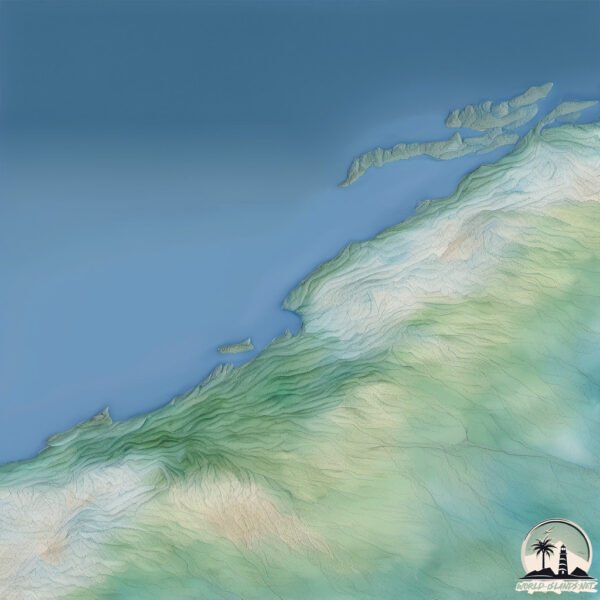
Size: 1.019 km²
Coastline: 5.1 km
Ocean: Arctic Ocean
Sea: Norwegian Sea
Continent: Europe
Husoya is a Small Island spanning 1 km² with a coastline of 5.1 km.
Archipel: –
Tectonic Plate: Eurasia – One of the world’s largest tectonic plates, the Eurasian Plate covers a significant portion of Europe and Asia. It’s characterized by diverse geological features, including the Ural Mountains, the European Plain, and the Himalayas formed from its collision with the Indian Plate.
The geographic heart of the island is pinpointed at these coordinates:
Latitude: 64.16645212 / Longitude: 9.88213367
Climate and weather of Husoya
Climate Zone: Temperate
Climate Details: Temperate Oceanic Climate
Temperature: Warm Summer
Climate Characteristics: Known for its moderate year-round temperatures with ample rainfall and no dry season. Warm summers are characteristic.
Topography and nature of Husoya
Timezone: UTC+01:00
Timezone places: Europe/Paris
Max. Elevation: 114 m
Mean Elevation: 48 m
Vegetation: Open Woodland
Tree Coverage: 41%
The mean elevation is 48 m. The highest elevation on the island reaches approximately 114 meters above sea level. The island is characterized by Plains: Flat, low-lying lands characterized by a maximum elevation of up to 200 meters. On islands, plains are typically coastal lowlands or central flat areas.
Dominating Vegetation: Open Woodland
Characterized by sparsely distributed trees with open canopy allowing sunlight to penetrate, supporting grasses and shrubs underneath. Often found in drier or transitional environments. Husoya has a tree cover of 41 %.
Vegetation: 8 vegetation zones – Very Highly Diverse Island
Islands in this range are ecological powerhouses, showcasing a wide array of vegetation zones. Each zone, from lush rainforests to arid scrublands, coastal mangroves to mountainous regions, contributes to a complex and interdependent ecosystem. These islands are often hotspots of biodiversity, supporting numerous species and intricate ecological processes.
Infrastructure and Travelling to Husoya
Does the island have a public airport? no.
There is no public and scheduled airport on Husoya. The nearest airport is Ørland Airport, located 22 km away.
Does the island have a major port? no.
There are no major ports on Husoya. The closest major port is KJERRINGOY, approximately 30 km away.
The mean population of Husoya is 11 per km². Husoya is Gently Populated. The island belongs to Norway.
Continuing your journey, Storfosna is the next notable island, situated merely km away.
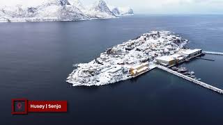
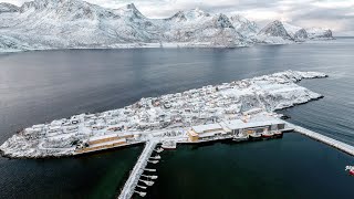
Husøy Island in Senja, Norway..!
Husøy Island in Senja, Norway Ko Yao Yai is a Thai island in the Andaman Sea, halfway between Phuket and Krabi.Husøy Island in Senja, Norway..!
Husøy Island in Senja, Norway Ko Yao Yai is a Thai island in the ...
Husøy Island in Senja, Norway Ko Yao Yai is a Thai island in the Andaman Sea, halfway between Phuket and Krabi.
Остров Husoy. Норвегия 🇳🇴
A charming island village in the Arctic Circle
Yes, you read that right! This tiny village only has 200 to 300 ...
Yes, you read that right! This tiny village only has 200 to 300 residents and you can walk the entire village in under 30 minutes.
Husoy Island looks so magical in winter! 😍 #dronefootage #husoy #norway #vacations #traveltips
Husøy – Norway’s Floating Village 🇳🇴✨ Follow For Amazing Nature Content 🇳🇴
Beautiful Village Husøy at Senja, Norway
Husoy Fishing Village Island in Senja, Norway
We went little icy dip to wash our bad smell and headed to this ...
We went little icy dip to wash our bad smell and headed to this picture perfect little fishing village on a island with a bridge ...
Husøy island in Senja, Norway
Flying over small Husøy island in July 2019. Shot with Mavic Air and ...
Flying over small Husøy island in July 2019. Shot with Mavic Air and edited on iPad with LumaFusion.
Husøy, the tiny Island near Senja, #norway
Driving in Norway - Husøy To Fjordgard - 4K60
Travel in Northern Norway, Husøy To Fjordgard in this 4k Real-Time ...
Travel in Northern Norway, Husøy To Fjordgard in this 4k Real-Time Scenic Drive. Enjoyed this video? Subscribe and Like to ...
Husoy Norway | Travel Trip Reel #shorts
Husoy Senja Travel in Norway | Travel Trip Reel #shorts #nordnorge ...
Husoy Senja Travel in Norway | Travel Trip Reel #shorts #nordnorge #nordland #youtubetrendingvideo #nature #traveltripreel ...
The island of Husøy, Senja, Norway
Husøy is a village in Senja Municipality in Troms county, Norway. The ...
Husøy is a village in Senja Municipality in Troms county, Norway. The village covers the entire island of Husøy which is located in ...
Husoy Senja Beautiful place in Norway | Travel Trip Reel #shorts
Husoy Senja Travel in Norway | Travel Trip Reel #shorts #nordnorge ...
Husoy Senja Travel in Norway | Travel Trip Reel #shorts #nordnorge #nordland #youtubetrendingvideo #nature #traveltripreel ...
Husoy i Senja - Four Seasons 4K
Short video from an amazing island located in North Norway. Husøy is a ...
Short video from an amazing island located in North Norway. Husøy is a village in Senja Municipality in Troms og Finnmark ...
Husøyfilm NY
Brødrene Karlsen AS åpner siste del av sitt nye industribygg.
Brødrene Karlsen AS åpner siste del av sitt nye industribygg.
Diving low towards Husøy in 📍 Senja, Norway ⛰ #explore #nature #travel #norway #beautiful #shorts
photography #naturelovers #travelphotography.
photography #naturelovers #travelphotography.
Ona and Husøya
A quick tour of the islands Ona and Husøya in Møre og Romsdal county, ...
A quick tour of the islands Ona and Husøya in Møre og Romsdal county, Norway. A beautiful example of a traditional fishing ...
Husoy Island, Norway
Husoy Island, Norway #norway #travel #shorts #nature #relaxing.
Husoy Island, Norway #norway #travel #shorts #nature #relaxing.
Husøy, Norway! With
Repost @nomadict #inrepostme @insaver.best —— Husøy, Norway! With ...
Repost @nomadict #inrepostme @insaver.best —— Husøy, Norway! With @ronald_soethje / You may be familiar with Senja for ...
The dark times of Senja island, Norway 🇳🇴!
The dark times of Senja island! From the end of November to the end of ...
The dark times of Senja island! From the end of November to the end of January the sun never rises above the horizon ( vidéo ...
🌊 Tiny Island, Big Views — Husøy Norway
Experience the amazing island village of Husøy in Norway. The tall ...
Experience the amazing island village of Husøy in Norway. The tall mountains, blue water, and small homes make this place look ...
husoy island 🇳🇴 #travel #viral #foryou #shorts
Residents of a remote island in Norway, strive to become the world's first time-free zone.
Residents of a remote island, situated north of the Arctic Circle in ...
Residents of a remote island, situated north of the Arctic Circle in West Tromsø, Norway, strive to become the world's first time-free ...
the Island of Husøy in Senja_Brødrene Karlsen Salmo
Husøy in Senja #http://www.nordlichter-fotoreise.ch.
Husøy in Senja #http://www.nordlichter-fotoreise.ch.
Husoy, Norway 🇳🇴 #shorts #travel
Norway is classified as Developed region: nonG7: Developed economies outside of the Group of Seven, characterized by high income and advanced economic structures. The level of income is High income: OECD.
News – Latest Updates and Headlines from Husoya
Stay informed with the most recent news and important headlines from Husoya. Here’s a roundup of the latest developments.
Loading...
Please note: The data used here has been primarily extracted from satellite readings. Deviations from exact values may occur, particularly regarding the height of elevations and population density. Land area and coastline measurements refer to average values at mean high tide.