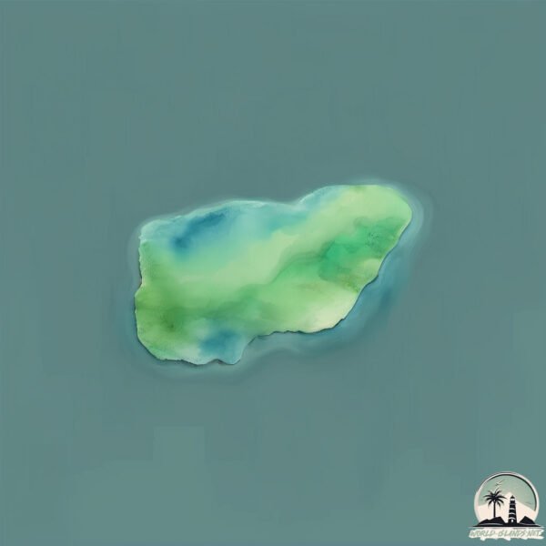
Welcome to Isla Lagora, a Temperate island in the South Pacific Ocean, part of the majestic Pacific Ocean. This guide offers a comprehensive overview of what makes Isla Lagora unique – from its geography and climate to its population, infrastructure, and beyond. Dive into the details:
Geography and size of Isla Lagora
Size: 0.104 km²
Coastline: 1.3 km
Ocean: Pacific Ocean
Sea: South Pacific Ocean
Continent: South America
Isla Lagora is a Tiny Island spanning 0.104 km² with a coastline of 1.3 km.
Archipel: –
Tectonic Plate: South America – A major plate covering the South American continent and part of the Atlantic Ocean, known for the Andes mountain range and significant seismic and volcanic activity.
The geographic heart of the island is pinpointed at these coordinates:
Latitude: -44.48972016 / Longitude: -73.53143711
Climate and weather of Isla Lagora
Climate Zone: Temperate
Climate Details: Temperate Oceanic Climate
Temperature: Warm Summer
Climate Characteristics: Known for its moderate year-round temperatures with ample rainfall and no dry season. Warm summers are characteristic.
Topography and nature of Isla Lagora
Timezone: UTC-04:00
Timezone places: America/La_Paz
Max. Elevation: -14 m
Mean Elevation: -44 m
Vegetation: Evergreen Broadleaf Forest
Tree Coverage: 78%
The mean elevation is -44 m. Remarkably, this unique island barely emerges above the sea level, showcasing nature’s fascinating interplay with the ocean. The island is characterized by Plains: Flat, low-lying lands characterized by a maximum elevation of up to 200 meters. On islands, plains are typically coastal lowlands or central flat areas.
Dominating Vegetation: Evergreen Broadleaf Forest
Characterized by dense, lush canopies of broadleaf trees that retain their leaves year-round. These forests are typically found in tropical and subtropical regions and are known for their high biodiversity. Isla Lagora has a tree cover of 78 %.
Vegetation: 1 vegetation zones – Minimal Diversity Island
These islands exhibit the most basic level of ecological diversity, often characterized by a single dominant vegetation type. This could be due to extreme environmental conditions, limited land area, or significant human impact. They represent unique ecosystems where specific species have adapted to thrive in these singular environments.
Infrastructure and Travelling to Isla Lagora
Does the island have a public airport? no.
There is no public and scheduled airport on Isla Lagora. The nearest airport is Mocopulli Airport, located 240 km away.
Does the island have a major port? no.
There are no major ports on Isla Lagora. The closest major port is PUERTO CHACABUCO, approximately 133 km away.
The mean population of Isla Lagora is 0 per km². Isla Lagora is Uninhabited. The island belongs to Chile.
Continuing your journey, Filomena is the next notable island, situated merely km away.
Laguna de Sete Cidades. Isla de São Miguel, Azores. #açores #azores #portugal
Las lagunas gemelas vistas desde lo alto del cráter. Impresionante São Miguel, las Azores son un paraíso.Laguna de Sete Cidades. Isla de São Miguel, Azores. #açores #azores #portugal
Las lagunas gemelas vistas desde lo alto del cráter. Impresionante São ...
Las lagunas gemelas vistas desde lo alto del cráter. Impresionante São Miguel, las Azores son un paraíso.
Exploring the real life mako island and finding the moon pool! Part 1 #h2ojustaddwater
Real life mermaid exploring mako island and finding the moon pool! my ...
Portugal, Azores, São Miguel Island
If you needed a reason to visit The Azores in Portugal...
If you needed a reason to visit The Azores in Portugal...
I found the real mako island moon pool and turned into a mermaid!
Kei Island Maluku "Mini Raja Ampat" (@ahmadnurfauji_ & 6 more) #keiisland #travel #maluku
Cred: @ahmadnurfauji_ @keisedjang_ @tatanuhuyanan @muhday_ ...
Cred: @ahmadnurfauji_ @keisedjang_ @tatanuhuyanan @muhday_ @asis_tharob.16 @rdwnharris @visit.kei All via TT Ever ...
Ponta Delgada | Azores - Portugal #travel #island #portugal #visitportugal #azores
You can see much more content and book experiences on the island of ...
You can see much more content and book experiences on the island of São Miguel in the Azores through our social networks or ...
FREE Tridents in Mermaid Isle?
Socials ♡ Twitch: twitch.tv/emperiellaa ♡ Twitter: ...
Island Lagoon
Napafresh at lamig ng tubig subra di nakakasawa maligo.
Napafresh at lamig ng tubig subra di nakakasawa maligo.
Azores: 5 Day Itinerary for Sao Miguel, One of 9 Islands off of Portugal #visitazores #getoutside
The Azores 5 Day Itunerary: Here are things to do for 5 days in Sao ...
The Azores 5 Day Itunerary: Here are things to do for 5 days in Sao Miguel. Where We Stayed was in Ponta Delgado - centrally ...
What is so special about São Miguel island in the Azores?
São Miguel is the ultimate destination for nature lovers. Every little ...
São Miguel is the ultimate destination for nature lovers. Every little corner, lagoon, waterfall, beach, is just breathtaking.
Palau Travel Guide: Best Places To Visit In 2026
Discover The Top 5 Places To Visit In Palau Travel Guide! From Rock ...
Discover The Top 5 Places To Visit In Palau Travel Guide! From Rock Islands to Jellyfish Lake to Ngardmau Waterfall to Milky Way ...
Finding Perfect Togean Islands Lagoon Anchorage #sailing #sulawesi #travel
We find another perfect, tropical lagoon anchorage amongst the reefs ...
We find another perfect, tropical lagoon anchorage amongst the reefs of the Togean Islands in Sulawesi, Indonesia. See our full ...
Italy’s Most Haunted Island
Poveglia Island, located in the foggy Venetian Lagoon of Italy, is one ...
Poveglia Island, located in the foggy Venetian Lagoon of Italy, is one of the most haunted places in the world. Its terrifying history ...
Azores Islands Volcanic Landscapes in Portugal 🇵🇹
Una de las islas más espectaculares de Europa
Imprescindibles de la isla de Flores Casccadas y piscinas -Poço de ...
Imprescindibles de la isla de Flores Casccadas y piscinas -Poço de Bacalhau -Poço Ribeira do Ferreiro -Cascata da Ribeira ...
Kiribati Island Travel Guide: Best Places to Visit In 2026
Top 5 Best Places to Visit In Kiribati Island Travel Guide! From ...
Top 5 Best Places to Visit In Kiribati Island Travel Guide! From Tarawa Atoll to Fanning Island to Abaiang to Christmas Island to ...
Man Builds a SELF-SUFFICIENT Floating Bamboo Island (Solo!) | @7Asian
Built on a tranquil lake nestled in the mountains, 7Asian's floating ...
Built on a tranquil lake nestled in the mountains, 7Asian's floating home is more than shelter: it's an ecosystem, handcrafted to ...
Magic Island Lagoon, Oahu
Mayotte, The Island In The Lagoon
00:00 Encircled by one of the world's largest enclosed lagoons, the ...
00:00 Encircled by one of the world's largest enclosed lagoons, the 101st French department is a real cultural crossroads between ...
A day in Lagoa - Sao Miguel - -Azores Portugal #pontadelgada #azores #portugal #europe
Discovering Aitutaki: A Journey to the Heart of the Cook Islands' Paradise!
Escape to the idyllic paradise of Aitutaki, a hidden gem in the Cook ...
Escape to the idyllic paradise of Aitutaki, a hidden gem in the Cook Islands, known for its turquoise lagoon, white sandy beaches, ...
🐢 Ilha Grande: Brazil’s Magical Island of Nature & Secrets!
Welcome to our channel! In this YouTube Short, we uncover fantastic ...
Welcome to our channel! In this YouTube Short, we uncover fantastic facts about Ilha Grande, Brazil – a breathtaking island ...
Hiking to Lagoa do Fogo in Sao Miguel Azores islands #azores #portugal #hiking
Seven Cities Lagoon - Azores Islands
This is the wonderful Seven Cities Lagoon "Lagoa das Sete Cidades", ...
This is the wonderful Seven Cities Lagoon "Lagoa das Sete Cidades", one of the most beautiful natural landscapes in the world, ...
Blue Lagoon Comino island Malta October 2025 Mediterranean #malta #island
Chile is classified as Emerging region: G20: Group of Twenty – Major economies comprising both developed and emerging countries, representing the world’s largest economies. The level of income is Upper middle income.
News – Latest Updates and Headlines from Isla Lagora
Stay informed with the most recent news and important headlines from Isla Lagora. Here’s a roundup of the latest developments.
Loading...
Please note: The data used here has been primarily extracted from satellite readings. Deviations from exact values may occur, particularly regarding the height of elevations and population density. Land area and coastline measurements refer to average values at mean high tide.