Welcome to Ronsard, a Dry island in the Indian Ocean, part of the majestic Indian Ocean. This guide offers a comprehensive overview of what makes Ronsard unique – from its geography and climate to its population, infrastructure, and beyond. Dive into the details:
Geography and size of Ronsard
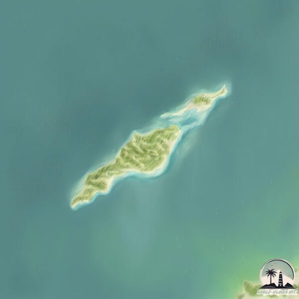
Size: 1.968 km²
Coastline: 10.1 km
Ocean: Indian Ocean
Sea: Indian Ocean
Continent: Oceania
Ronsard is a Small Island spanning 2 km² with a coastline of 10.1 km.
Archipel: –
Tectonic Plate: Australia – A major tectonic plate covering Australia, New Zealand, and parts of the Indian and Pacific Oceans, known for its relative stability and occasional seismic activity.
The geographic heart of the island is pinpointed at these coordinates:
Latitude: -20.52803986 / Longitude: 117.86004792
Climate and weather of Ronsard
Climate Zone: Dry
Climate Details: Hot Deserts Climate
Temperature: Hot
Climate Characteristics: Dominated by extremely hot temperatures, this climate is marked by minimal rainfall and barren landscapes. Nights often experience drastic temperature drops.
Topography and nature of Ronsard
Timezone: UTC+08:00
Timezone places: Australia/Perth
Max. Elevation: 8 m
Mean Elevation: 5 m
Vegetation: Shrubland
Tree Coverage: 15%
The mean elevation is 5 m. The highest elevation on the island reaches approximately 8 meters above sea level. The island is characterized by Plains: Flat, low-lying lands characterized by a maximum elevation of up to 200 meters. On islands, plains are typically coastal lowlands or central flat areas.
Dominating Vegetation: Shrubland
Dominated by shrubs and small bushes, these areas are typical in dry, rocky, or sandy environments, as well as in regions with poor soil fertility. Ronsard has a tree cover of 15 %.
Vegetation: 1 vegetation zones – Minimal Diversity Island
These islands exhibit the most basic level of ecological diversity, often characterized by a single dominant vegetation type. This could be due to extreme environmental conditions, limited land area, or significant human impact. They represent unique ecosystems where specific species have adapted to thrive in these singular environments.
Infrastructure and Travelling to Ronsard
Does the island have a public airport? no.
There is no public and scheduled airport on Ronsard. The nearest airport is Port Hedland International Airport, located 85 km away.
Does the island have a major port? no.
There are no major ports on Ronsard. The closest major port is PORT WALCOTT, approximately 75 km away.
The mean population of Ronsard is 0 per km². Ronsard is Uninhabited. The island belongs to Australia.
Continuing your journey, Depuch is the next notable island, situated merely km away.
Ronsard Resort IRABU(ロンサールリゾート・イラブ)へようこそ
プライベートヴィラ「Ronsard Resort IRABU(ロンサールリゾート・イラブ)」は、伊良部ブルーをのぞむ感動のロケーション。Ronsard Resort IRABU(ロンサールリゾート・イラブ)へようこそ
プライベートヴィラ「Ronsard Resort IRABU(ロンサールリゾート・イラブ)」は、伊良部ブルーをのぞむ感動のロケーション。
プライベートヴィラ「Ronsard Resort IRABU(ロンサールリゾート・イラブ)」は、伊良部ブルーをのぞむ感動のロケーション。
Exécutif vue sur l’ocean cinq @ Ronsard Resort IRABU | エグゼクティフ オーシャン サンク @ ロンサールリゾート・イラブ
We visited a private villa in Miyako Island. It was absolutely ...
We visited a private villa in Miyako Island. It was absolutely amazing, so we wanted to share it with everyone! Don't miss a ...
Exécutif vue sur l’ocean cinq @ Ronsard Resort IRABU | エグゼクティフ オーシャン サンク @ ロンサールリゾート・イラブ
We visited a private villa in Miyako Island. It was absolutely ...
We visited a private villa in Miyako Island. It was absolutely amazing, so we wanted to share it with everyone! Don't miss a ...
Ronsard Resort IRABU | ロンサールリゾート・イラブ
This time, I enjoyed a private villa on Miyako Island. ...
This time, I enjoyed a private villa on Miyako Island. 今回は、宮古島のプライベートヴィラを堪能してきました。
BEHWE GH tour to ISLAND 69 With Ecole Ronsard - 2024
PLEASE SUBSCRIBE! This Video is for Portfolio Purpose Only! For ...
PLEASE SUBSCRIBE! This Video is for Portfolio Purpose Only! For bookings:
hirekad@gmail.com / linktr.ee/directorKAD (c) 2024 ...
Chorale ronsard 250119 island in the sun
【伊良部島】全室、全空間オーシャンビュー!絶景プライベートヴィラ/たびらい沖縄
編集部が体験取材/ 宮古ブルーを望むプライベートヴィラ ✨ 沖縄・伊良部島にある Ronsard Resort IRABUでは、 客室・専用 ...
編集部が体験取材/ 宮古ブルーを望むプライベートヴィラ ✨ 沖縄・伊良部島にある Ronsard Resort IRABUでは、 客室・専用 ...
76 Ronsard Dr, San Remo - FOR SALE by Michael O'Brien - ACTON Mandurah
Take a Virtual Tour of this delightful 4x2 family home situated in the ...
Take a Virtual Tour of this delightful 4x2 family home situated in the sought after beachside location of San Remo. Featuring a ...
Beverly Sills - Milhaud: QUATRE CHANSONS DE RONSARD, Long Island recital, 1972, High D
THE MUSIC: Darius Milhaud's song cycle "Quatre Chansons de Ronsard" ...
THE MUSIC: Darius Milhaud's song cycle "Quatre Chansons de Ronsard" was written in 1941 and dedicated to Lily Pons, who ...
ELIZABETH PARCELLS DARIUS MILHAUD Chanson de Ronsard (Composed for Lily Pons)
Track with Ronsard Masamba & Sasso & Mayhew we just run 5:5
LE MIE ROSE PIERRE DE RONSARD - Fatto in Casa da Benedetta
LE MIE ROSE PIERRE DE RONSARD - Le rose che tengo nel portico son le ...
LE MIE ROSE PIERRE DE RONSARD - Le rose che tengo nel portico son le Pierre de Ronsard, molto rustiche e facili da coltivare ...
Bali János (1963-) : Pierre de Ronsard lázálma (2019) ősbemutató
Molnár Andrea - furulya, művészeti vezető Kállay Katalin - furulya, ...
Molnár Andrea - furulya, művészeti vezető Kállay Katalin - furulya, Szabó Zsolt - viola da gamba Schallinger-Foidl Artúr ...
Island in the sun / Weezer (Chorale du Collège Pierre de Ronsard, Tremblay-en-France)
Spectacle chorale : "Que d'émotions !" Direction musicale et ...
Spectacle chorale : "Que d'émotions !" Direction musicale et arrangements : Besnier Sylvain Filmé le 25 janvier 2019 à L'Odéon, ...
Chansons de Ronsard, Op. 223: À Cupidon
Provided to YouTube by Universal Music Group Chansons de Ronsard, Op. ...
Provided to YouTube by Universal Music Group Chansons de Ronsard, Op. 223: À Cupidon · Rita Streich · Erik Werba Rita ...
Milhaud's Quatre Chansons de Ronsard - Alissa Roca & The Meadows Symphony Orchestra
Darius Milhaud's Quatre Chansons de Ronsard Performed by the Meadows ...
Darius Milhaud's Quatre Chansons de Ronsard Performed by the Meadows Symphony Orchestra Southern Methodist University ...
Maya Vansuch - Chansons de Ronsard (1941): "Dieu vous gard' " by Darius Milhaud
Maya Vansuch - soprano, Yujung Um - piano Senior Recital, April 15, ...
Maya Vansuch - soprano, Yujung Um - piano Senior Recital, April 15, 2018. Recital Hall, Jacobs School of Music, Indiana ...
Красень🌹П’єр
Наступне відео про піджмвку троянд влітку В кадрі Троянда П'єр де ...
Наступне відео про піджмвку троянд влітку В кадрі Троянда П'єр де Ронсар Pierre de Ronsard ✓троянда - клаймбер, ...
Ronsard Masamba's Goal v. Rhode Island Reds
Ronsard Masamba scores the equalizer vs. the Rhode Island Reds May ...
Ronsard Masamba scores the equalizer vs. the Rhode Island Reds May 30th, 2015 Cawley Stadium Lowell, Massachusetts.
My Stupeflix Video
Created using the Stupeflix Youtube App.
Created using the Stupeflix Youtube App.
Chansons de Ronsard, Op. 223: Tais-toi, babillarde
Provided to YouTube by Universal Music Group Chansons de Ronsard, Op. ...
Provided to YouTube by Universal Music Group Chansons de Ronsard, Op. 223: Tais-toi, babillarde · Rita Streich · Erik Werba ...
Chorale ronsard 250119 I want you back
Adventure island - Orchestre d'Harmonie de la Ville de Bouzonville
Concert au château Saint SIXTE de FREISTROFF.
Concert au château Saint SIXTE de FREISTROFF.
Wonders of Morocco | The Most Amazing Places in Morocco | Travel Video 4K
Welcome to our channel! In today's video, we embark on an incredible ...
Welcome to our channel! In today's video, we embark on an incredible journey through the wonders of Morocco. From the ...
Australia is classified as Developed region: nonG7: Developed economies outside of the Group of Seven, characterized by high income and advanced economic structures. The level of income is High income: OECD.
News – Latest Updates and Headlines from Ronsard
Stay informed with the most recent news and important headlines from Ronsard. Here’s a roundup of the latest developments.
Loading...
Please note: The data used here has been primarily extracted from satellite readings. Deviations from exact values may occur, particularly regarding the height of elevations and population density. Land area and coastline measurements refer to average values at mean high tide.