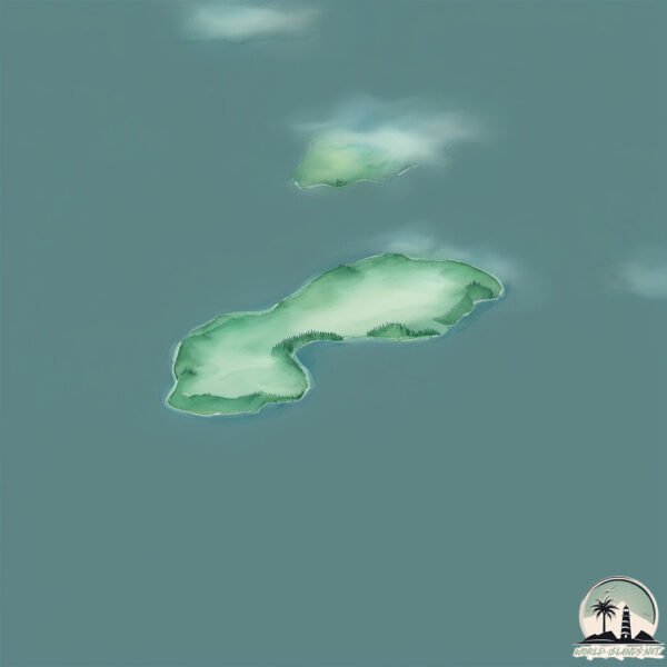
Welcome to Södra Dunskär, a Continental island in the Gulf of Bothnia, part of the majestic Atlantic Ocean. This guide offers a comprehensive overview of what makes Södra Dunskär unique – from its geography and climate to its population, infrastructure, and beyond. Dive into the details:
Geography and size of Södra Dunskär
Size: 0.115 km²
Coastline: 1.6 km
Ocean: Atlantic Ocean
Sea: Gulf of Bothnia
Continent: Europe
Södra Dunskär is a Tiny Island spanning 0.115 km² with a coastline of 1.6 km.
Archipel: –
Tectonic Plate: Eurasia – One of the world’s largest tectonic plates, the Eurasian Plate covers a significant portion of Europe and Asia. It’s characterized by diverse geological features, including the Ural Mountains, the European Plain, and the Himalayas formed from its collision with the Indian Plate.
The geographic heart of the island is pinpointed at these coordinates:
Latitude: 59.89850637 / Longitude: 22.23418646
Climate and weather of Södra Dunskär
Climate Zone: Continental
Climate Details: Warm-Summer Humid Continental Climate
Temperature: Warm Summer
Climate Characteristics: Features warm summers and cold winters with consistent precipitation, common in higher latitudes.
Topography and nature of Södra Dunskär
Timezone: UTC+02:00
Timezone places: Europe/Helsinki
Max. Elevation: 23 m
Mean Elevation: 22 m
Vegetation: Evergreen Needleleaf Forest
Tree Coverage: 87%
The mean elevation is 22 m. The highest elevation on the island reaches approximately 23 meters above sea level. The island is characterized by Plains: Flat, low-lying lands characterized by a maximum elevation of up to 200 meters. On islands, plains are typically coastal lowlands or central flat areas.
Dominating Vegetation: Evergreen Needleleaf Forest
Dominated by evergreen coniferous trees such as pines and firs, which retain their needle-like leaves throughout the year. These forests are often found in cooler climates. Södra Dunskär has a tree cover of 87 %.
Vegetation: 1 vegetation zones – Minimal Diversity Island
These islands exhibit the most basic level of ecological diversity, often characterized by a single dominant vegetation type. This could be due to extreme environmental conditions, limited land area, or significant human impact. They represent unique ecosystems where specific species have adapted to thrive in these singular environments.
Infrastructure and Travelling to Södra Dunskär
Does the island have a public airport? no.
There is no public and scheduled airport on Södra Dunskär. The nearest airport is Turku Airport, located 68 km away.
Does the island have a major port? no.
There are no major ports on Södra Dunskär. The closest major port is PARGAS, approximately 46 km away.
The mean population of Södra Dunskär is per km². Södra Dunskär is . The island belongs to Finland.
Continuing your journey, Biskopsö is the next notable island, situated merely km away.
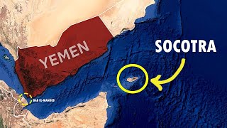
Socotra, Yemen – The Island I’ll Never Forget
I traveled to Socotra, Yemen - one of the world's most isolated and surreal islands - and what I discovered left me speechless!Socotra, Yemen – The Island I’ll Never Forget
I traveled to Socotra, Yemen - one of the world's most isolated and ...
I traveled to Socotra, Yemen - one of the world's most isolated and surreal islands - and what I discovered left me speechless!
Socotra - The treasure island between Yemen and Somalia | DW Documentary
The tiny, picturesque island is not typical of the area. It is part of ...
The tiny, picturesque island is not typical of the area. It is part of Yemen, but far away from the civil war. Even many people well ...
Entering The World’s Most Dangerous Island (Socotra)
Socotra - The WORLD'S most Mysterious Island 🇾🇪 (Yemen)
Socotra, Yemen a mysterious island island off the Horn of Africa, ...
Socotra, Yemen a mysterious island island off the Horn of Africa, nicknamed the Most alien place on earth where over half the ...
The Alien Beauty of Socotra Island
The remote island of Socotra looks like a landscape out of a sci-fi ...
The remote island of Socotra looks like a landscape out of a sci-fi film. Over millions of years, the isolated island in the Arabian ...
What on Earth is Socotra? (Not Yemen)
Socotra is an island off the coast of Yemen, famous for its natural ...
Socotra is an island off the coast of Yemen, famous for its natural features and one-of-a-kind ecosystems. While it's officially part of ...
Why Socotra Is The Weirdest Island On Earth
7 days in Yemen's Mysterious Island Paradise (SOCOTRA 2025)
The Weirdest Island On Earth - Socotra
Discover Sokotra, a mesmerizing island in the Indian Ocean, located ...
Discover Sokotra, a mesmerizing island in the Indian Ocean, located around 150 miles from Somalia and 220 miles from Yemen.
The Hidden Beauty of Socotra
socotra #yemen #geography #aaronsgeographyworld #subscribe #asia ...
socotra #yemen #geography #aaronsgeographyworld #subscribe #asia #somalia #dragonbloodtree #arid #bats #sunbird #island ...
48 hours on the remote island of Socotra
Yemen's Socotra Island: Why It's So Unique? | Facta Geographica
Socotra Island, a remote island in Yemen, is home to bizarre and ...
Socotra Island, a remote island in Yemen, is home to bizarre and endangered species like the Socotra cactus and the Socotra ...
SOCOTRA: the most beautiful place in the world #traveler #socotra #yemen #worldtravel #nature
🌍 Socotra Island: Yemen’s Biodiversity Gem in the Indian Ocean | NEXT MAPS
Socotra Island — a remote Yemeni archipelago in the northwest Indian ...
Socotra Island — a remote Yemeni archipelago in the northwest Indian Ocean — is often called the “Galápagos of the Indian ...
The Island Hidden From the World for 6 Million Years
Pasikeiskite filmo kalbą į LIETUVIŲ paspaudę playeryje Settings ...
Pasikeiskite filmo kalbą į LIETUVIŲ paspaudę playeryje Settings mygtuką. (Pasirinkite: Audio Track / звуковая дорожка) Journey ...
Socotra island
This unique place is Socotra Island in Yemen is one of the most ...
This unique place is Socotra Island in Yemen is one of the most isolated places on Earth. Most of its plants can't be found ...
SOCOTRA - The Most Strategic Island in the Indian Ocean
Nestled between the tip of Somalia and the Gulf of Aden, Socotra is ...
Nestled between the tip of Somalia and the Gulf of Aden, Socotra is the most strategically important island in the entire Indian ...
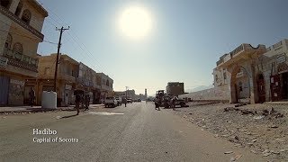
Hadibo, Socotra Island, Yemen - Scene Documentary "Socotra: The Hidden Land"
City of Hadibo, Capital of the Island of Socotra, Yemen. Scene of the ...
City of Hadibo, Capital of the Island of Socotra, Yemen. Scene of the Documentary film of Socotra Island. Title: "Socotra: The ...
Waxaan tagay jazirada ugu halista badan socotra | ma aamineys waxan kala kulmay 🇾🇪
Waxaan tagay jazirada ugu halista badan socotra | ma aamineys waxan ...
Waxaan tagay jazirada ugu halista badan socotra | ma aamineys waxan kala kulmay Credit : @drewbinsky.
#shorts The paradise island between #somalia and #yemen
somalia #uae #socotra #shorts Jasiirada Socotra Somalia iyo Yemen kee ...
somalia #uae #socotra #shorts Jasiirada Socotra Somalia iyo Yemen kee baa leh.
Spending the night with a Caveman! #travelvlog #travel #socotra #caveman #yemen #adventuretravel
You won’t believe his story. | S8, EP59
In this episode, I meet the caveman of Socotra and he shows how easily ...
In this episode, I meet the caveman of Socotra and he shows how easily he catches all sorts of marine life to eat and survive in the ...
Jasiirada Socotra | Jasiirad somaali leedahay mise yaman
My night with the cave man of Socotra (Yemen) #traveler #yemen #socotra #adventuretravel
Waxaan booqday Jasiiradda ugu Dhirta badan 🌴 Sacadadiin Island
Muqaalkan waa Jasiiradda Sacaddiin – jasiiraddii 10aad ee safarkeenna ...
Muqaalkan waa Jasiiradda Sacaddiin – jasiiraddii 10aad ee safarkeenna Badda Cas! Waxay Jasiiradan ku taallaa gobolka ...
Finland is classified as Developed region: nonG7: Developed economies outside of the Group of Seven, characterized by high income and advanced economic structures. The level of income is High income: OECD.
News – Latest Updates and Headlines from Södra Dunskär
Stay informed with the most recent news and important headlines from Södra Dunskär. Here’s a roundup of the latest developments.
Loading...
Please note: The data used here has been primarily extracted from satellite readings. Deviations from exact values may occur, particularly regarding the height of elevations and population density. Land area and coastline measurements refer to average values at mean high tide.