Welcome to Amatignak, a Polar island in the North Pacific Ocean, part of the majestic Pacific Ocean. This guide offers a comprehensive overview of what makes Amatignak unique – from its geography and climate to its population, infrastructure, and beyond. Dive into the details:
Geography and size of Amatignak
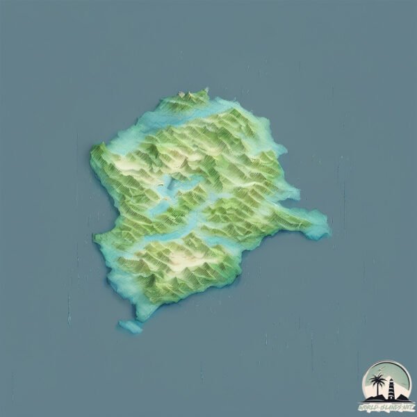
Size: 34.7 km²
Coastline: 54.8 km
Ocean: Pacific Ocean
Sea: North Pacific Ocean
Continent: North America
Amatignak is a Medium Island spanning 35 km² with a coastline of 55 km.
Archipel: Aleutian Islands – A chain of islands stretching from Alaska to Russia, known for their rugged beauty, abundant wildlife, and volcanic activity.
Tectonic Plate: North America – Covers North America and parts of the Atlantic and Arctic Oceans, characterized by diverse geological features and varying levels of seismic activity.
The geographic heart of the island is pinpointed at these coordinates:
Latitude: 51.26106318 / Longitude: -179.10852856
Climate and weather of Amatignak
Climate Zone: Polar
Climate Details: Tundra
Temperature: Cold
Climate Characteristics: The tundra climate features long, extremely cold winters and short, cool summers. Vegetation is limited to mosses, lichens, and small shrubs due to the low temperatures and short growing seasons. Biodiversity is low, but some specialized species thrive.
Topography and nature of Amatignak
Timezone: UTC-10:00
Timezone places: Pacific/Honolulu
Max. Elevation: 549 m
Mean Elevation: 254 m
Vegetation: Open Woodland
Tree Coverage: 47%
The mean elevation is 254 m. The highest elevation on the island reaches approximately 549 meters above sea level. The island is characterized by Plateau: Elevated flatlands rising sharply above the surrounding area, with a maximum elevation over 500 meters but a mean elevation less than 300 meters, forming unique highland areas on islands.
Dominating Vegetation: Open Woodland
Characterized by sparsely distributed trees with open canopy allowing sunlight to penetrate, supporting grasses and shrubs underneath. Often found in drier or transitional environments. Amatignak has a tree cover of 47 %.
Vegetation: 12 vegetation zones – Exceptionally Diverse Island
Islands with more than ten vegetation zones are among the most ecologically rich and varied in the world. These islands are akin to miniature continents, boasting an incredible array of ecosystems. The sheer range of habitats, from high peaks to deep valleys, rainforests to deserts, creates a mosaic of life that is unparalleled. They are crucial for conservation and ecological studies.
Infrastructure and Travelling to Amatignak
Does the island have a public airport? no.
There is no public and scheduled airport on Amatignak. The nearest airport is Adak Airport, located 277 km away.
Does the island have a major port? no.
There are no major ports on Amatignak. The closest major port is ADAK NAVAL AIR STATION, approximately 278 km away.
The mean population of Amatignak is 0 per km². Amatignak is Uninhabited. The island belongs to United States of America.
Continuing your journey, Ulak is the next notable island, situated merely km away.
Mag 6earthquake Amatignak Island, Alaska
Mag 6earthquake Amatignak Island, Alaska.Mag 6earthquake Amatignak Island, Alaska
Mag 6earthquake Amatignak Island, Alaska.
Mag 6earthquake Amatignak Island, Alaska.
Amatignak Island, Alaska Earthquake May 23rd, 2019
Shorts #Shorts #Shorts #Shorts #Shorts #Shorts #AmatignakIsland ...
Shorts #Shorts #Shorts #Shorts #Shorts #Shorts #AmatignakIsland #Alaska #Earthquake on May 23rd, 2019. Don't forget to ...
How This Alaskan Island is South of London (Aleutian Islands)
Did you know that there are Alaskan islands that are more southern ...
Did you know that there are Alaskan islands that are more southern than London? Today we explore the Aleutian Islands, ...
I visited America’s most remote island (Adak, AK)
Amatignak Island, Alaska Earthquake September 8th, 2019
Shorts #Shorts #Shorts #Shorts #Shorts #Shorts #AmatignakIsland ...
Shorts #Shorts #Shorts #Shorts #Shorts #Shorts #AmatignakIsland #Alaska #Earthquake on September 9th, 2019. Don't forget to ...
Earthquake Amatignak Island Alaska 2019-09-09
2019-09-09T03:54:08.784Z 45km NE of Amatignak Island, Alaska 51.543 ...
2019-09-09T03:54:08.784Z 45km NE of Amatignak Island, Alaska 51.543 lat -178.6387 lon 35 depth 5.3 mag Earthquake ...
Amatignak Island, Alaska Earthquake October 16th, 2019
Shorts #Shorts #Shorts #Shorts #Shorts #Shorts #AmatignakIsland ...
Shorts #Shorts #Shorts #Shorts #Shorts #Shorts #AmatignakIsland #Alaska #Earthquake on October 16th, 2019. Don't forget to ...
Amatignak Island, Alaska Earthquake February 15th, 2019
Shorts #Shorts #Shorts #Shorts #Shorts #Shorts #AmatignakIsland ...
Shorts #Shorts #Shorts #Shorts #Shorts #Shorts #AmatignakIsland #Alaska #earthquake February 15th, 2019. Don't forget to ...
Amatignak Island, Alaska Earthquake January 5th, 2019
Shorts #Shorts #Shorts #Shorts #Shorts #Shorts #DURecorder #Alaska ...
Shorts #Shorts #Shorts #Shorts #Shorts #Shorts #DURecorder #Alaska #Earthquake This is my video recorded with DU Recorder ...
Amatignak Island, Alaska Earthquake August 17th, 2018
Shorts #Shorts #Shorts #Shorts #Shorts #Shorts This is my video ...
Shorts #Shorts #Shorts #Shorts #Shorts #Shorts This is my video recorded with DU Recorder. It's easy to record your screen and ...
5.0 Earthquake Amatignak Island, Alaska 24-11-19
Shorts #Shorts #Shorts #Shorts #Shorts #Shorts #AmatignakIsland ...
Shorts #Shorts #Shorts #Shorts #Shorts #Shorts #AmatignakIsland #Alaska #Earthquake on November 24th, 2019. Don't forget to ...
5.2 Earthquake Amatignak Island, Alaska 26-1-20
Shorts #Shorts #Shorts #Shorts #Shorts #Shorts #AmatignakIsland ...
Shorts #Shorts #Shorts #Shorts #Shorts #Shorts #AmatignakIsland #Alaska #Earthquake on January 26th, 2019. Don't forget to ...
5.3 Earthquake Amatignak Island, Alaska 28-1-20
Shorts #Shorts #Shorts #Shorts #Shorts #Shorts #AmatignakIsland ...
Shorts #Shorts #Shorts #Shorts #Shorts #Shorts #AmatignakIsland #Alaska #Earthquake on January 28th, 2019. Don't forget to ...
Seismic Data of a 5.7 Earthquake Off the Coast of Amatignak Island, Alaska
34 Miles WSW of Amatignak Island, Alaska | Magnitude: 5.7 Depth: 14 ...
34 Miles WSW of Amatignak Island, Alaska | Magnitude: 5.7 Depth: 14 Miles | March 2, 12:31 AM UTC Please support this channel ...
5.2 Earthquake Amatignak Island, Alaska 1-1-20
Shorts #Shorts #Shorts #Shorts #Shorts #Shorts #AmatignakIsland ...
Shorts #Shorts #Shorts #Shorts #Shorts #Shorts #AmatignakIsland #Alaska #Earthquake on January 1st, 2020. Don't forget to ...
6.1 Earthquake Amatignak Island, Alaska 26-1-20
Shorts #Shorts #Shorts #Shorts #Shorts #Shorts #AmatignakIsland ...
Shorts #Shorts #Shorts #Shorts #Shorts #Shorts #AmatignakIsland #Alaska #Earthquake on January 26th, 2019. Don't forget to ...
5.8 Earthquake Amatignak Island, Alaska 3-1-20
Shorts #Shorts #Shorts #Shorts #Shorts #Shorts #AmatignakIsland ...
Shorts #Shorts #Shorts #Shorts #Shorts #Shorts #AmatignakIsland #Alaska #Earthquake on March 1st, 2020. Don't forget to ...
Seismic Data of a 6.1 Earthquake Off the Coast of Amatignak Island, Alaska
35 Miles W of Amatignak Island, Alaska | Magntidue: 6.1 Depth: 17 ...
35 Miles W of Amatignak Island, Alaska | Magntidue: 6.1 Depth: 17 Miles | January 26, 6:31 AM UTC Please support this channel ...
5.6 Earthquake Amatignak Island, Alaska 26-1-20
Shorts #Shorts #Shorts #Shorts #Shorts #Shorts #AmatignakIsland ...
Shorts #Shorts #Shorts #Shorts #Shorts #Shorts #AmatignakIsland #Alaska #Earthquake on January 26th, 2019. Don't forget to ...
5.5 Earthquake Amatignak Island, Alaska 26-1-20
Shorts #Shorts #Shorts #Shorts #Shorts #Shorts #AmatignakIsland ...
Shorts #Shorts #Shorts #Shorts #Shorts #Shorts #AmatignakIsland #Alaska #Earthquake on January 26th, 2019. Don't forget to ...
6.1 Earthquake Amatignak Island, Alaska 1-12-19
Shorts #Shorts #Shorts #Shorts #Vlogmas #Shorts #Shorts ...
Shorts #Shorts #Shorts #Shorts #Vlogmas #Shorts #Shorts #AmatignakIsland #Alaska #Earthquake on December 1st, 2019.
Strongest Earthquake of the Day: 1-12-19 Amatignak Island, Alaska
Shorts #Shorts #Shorts #Shorts #Vlogmas #Shorts #Shorts ...
Shorts #Shorts #Shorts #Shorts #Vlogmas #Shorts #Shorts #AmatignakIsland #Alaska #Earthquake on December 1st, 2019.
5.2 Earthquake Amatignak Island, Alaska 27-1-20
Shorts #Shorts #Shorts #Shorts #Shorts #Shorts #AmatignakIsland ...
Shorts #Shorts #Shorts #Shorts #Shorts #Shorts #AmatignakIsland #Alaska #Earthquake on January 27th, 2019. Don't forget to ...
5.7 Earthquake Amatignak Island, Alaska 25-1-20
Shorts #Shorts #Shorts #Shorts #Shorts #Shorts #AmatignakIsland ...
Shorts #Shorts #Shorts #Shorts #Shorts #Shorts #AmatignakIsland #Alaska #Earthquake on January 25th, 2019. Don't forget to ...
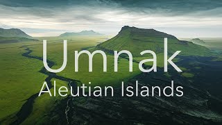
Umnak - Aleutian Islands
40 day long trip across the Umnak Island The Aleutian Islands are an ...
40 day long trip across the Umnak Island The Aleutian Islands are an archipelago of 110 volcanic islands in the North Pacific ...
United States of America is classified as Developed region: G7: Group of Seven – Major advanced economies, including Canada, France, Germany, Italy, Japan, the United Kingdom, and the United States. The level of income is High income: OECD.
News – Latest Updates and Headlines from Amatignak
Stay informed with the most recent news and important headlines from Amatignak. Here’s a roundup of the latest developments.
Loading...
Please note: The data used here has been primarily extracted from satellite readings. Deviations from exact values may occur, particularly regarding the height of elevations and population density. Land area and coastline measurements refer to average values at mean high tide.