Andronica
Welcome to Andronica, a Continental island in the Gulf of Alaska, part of the majestic Pacific Ocean. This guide offers a comprehensive overview of what makes Andronica unique – from its geography and climate to its population, infrastructure, and beyond. Dive into the details:
- Geography and Size: Explore the island’s size and location.
- Climate and Weather: Weather patterns and temperature.
- Topography and Nature: Uncover the natural wonders of the island.
- Infrastructure and Travelling: Insights on reaching, staying, and making the most of your visit.
- News and Headlines: Latest News.
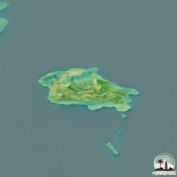
Geography and size of Andronica
Size: 15 km²
Coastline: 31.8 km
Ocean: Pacific Ocean
Sea: Gulf of Alaska
Continent: North America
Andronica is a Medium Island spanning 15 km² with a coastline of 32 km.
Archipel: Aleutian Islands – A chain of islands stretching from Alaska to Russia, known for their rugged beauty, abundant wildlife, and volcanic activity.
Tectonic Plate: North America – Covers North America and parts of the Atlantic and Arctic Oceans, characterized by diverse geological features and varying levels of seismic activity.
The geographic heart of the island is pinpointed at these coordinates:
Latitude: 55.3245001 / Longitude: -160.07117486
Climate and weather of Andronica
Climate Zone: Continental
Climate Details: Subarctic Climate
Temperature: Cold Summer
Climate Characteristics: Characterized by long, extremely cold winters and short, cool summers, often found in northern latitudes of North America and Eurasia.
Topography and nature of Andronica
Timezone: UTC-09:00
Timezone places: America/Anchorage
Max. Elevation: 311 m
Mean Elevation: 141 m
Vegetation: Wetland
Tree Coverage: 24%
The mean elevation is 141 m. The highest elevation on the island reaches approximately 311 meters above sea level. The island is characterized by Hills: Gently sloping landforms with rounded tops, having a maximum elevation between 200 and 500 meters. Hills contribute to a varied landscape on islands.
Dominating Vegetation: Wetland
These areas are saturated with water, either permanently or seasonally, and support aquatic plants. Wetlands are important for biodiversity and water filtration. Andronica has a tree cover of 24 %.
Vegetation: 8 vegetation zones – Very Highly Diverse Island
Islands in this range are ecological powerhouses, showcasing a wide array of vegetation zones. Each zone, from lush rainforests to arid scrublands, coastal mangroves to mountainous regions, contributes to a complex and interdependent ecosystem. These islands are often hotspots of biodiversity, supporting numerous species and intricate ecological processes.
Infrastructure and Travelling to Andronica
Does the island have a public airport? no.
There is no public and scheduled airport on Andronica. The nearest airport is Chignik Lake Airport, located 173 km away.
Does the island have a major port? no.
There are no major ports on Andronica. The closest major port is UNGA, approximately 46 km away.
The mean population of Andronica is 0 per km². Andronica is Uninhabited. The island belongs to United States of America.
Continuing your journey, Korovin is the next notable island, situated merely km away.
The Story Of Medusa | Beautiful Maiden Cursed By Athena | Greek Mythology


United States of America is classified as Developed region: G7: Group of Seven – Major advanced economies, including Canada, France, Germany, Italy, Japan, the United Kingdom, and the United States. The level of income is High income: OECD.
News – Latest Updates and Headlines from Andronica
Stay informed with the most recent news and important headlines from Andronica. Here’s a roundup of the latest developments.
Please note: The data used here has been primarily extracted from satellite readings. Deviations from exact values may occur, particularly regarding the height of elevations and population density. Land area and coastline measurements refer to average values at mean high tide.