
Badger
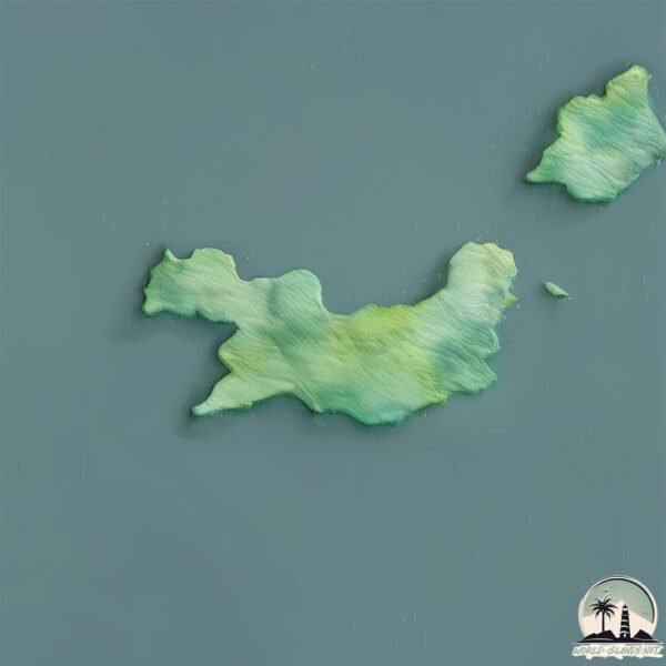
Welcome to Badger, a Temperate island in the Bass Strait, part of the majestic Pacific Ocean. This guide offers a comprehensive overview of what makes Badger unique – from its geography and climate to its population, infrastructure, and beyond. Dive into the details:
- Geography and Size: Explore the island’s size and location.
- Climate and Weather: Weather patterns and temperature.
- Topography and Nature: Uncover the natural wonders of the island.
- Infrastructure and Travelling: Insights on reaching, staying, and making the most of your visit.
- News and Headlines: Latest News.
Geography and size of Badger
Size: 13.3 km²
Coastline: 32.3 km
Ocean: Pacific Ocean
Sea: Bass Strait
Continent: Oceania
Badger is a Medium Island spanning 13 km² with a coastline of 32 km.
Archipel: –
Tectonic Plate: Australia – A major tectonic plate covering Australia, New Zealand, and parts of the Indian and Pacific Oceans, known for its relative stability and occasional seismic activity.
The geographic heart of the island is pinpointed at these coordinates:
Latitude: -40.30903565 / Longitude: 147.87501343
Climate and weather of Badger
Climate Zone: Temperate
Climate Details: Temperate Oceanic Climate
Temperature: Warm Summer
Climate Characteristics: Known for its moderate year-round temperatures with ample rainfall and no dry season. Warm summers are characteristic.
Topography and nature of Badger
Timezone: UTC+10:00
Timezone places: Australia/Sydney
Max. Elevation: 17 m
Mean Elevation: 10 m
Vegetation: Open Woodland
Tree Coverage: 63%
The mean elevation is 10 m. The highest elevation on the island reaches approximately 17 meters above sea level. The island is characterized by Plains: Flat, low-lying lands characterized by a maximum elevation of up to 200 meters. On islands, plains are typically coastal lowlands or central flat areas.
Dominating Vegetation: Open Woodland
Characterized by sparsely distributed trees with open canopy allowing sunlight to penetrate, supporting grasses and shrubs underneath. Often found in drier or transitional environments. Badger has a tree cover of 63 %.
Vegetation: 5 vegetation zones – Highly Diverse Island
With five different vegetation zones, these islands offer a rich tapestry of ecosystems. The variety could include dense forests, open meadows, wetlands, coastal zones, and more. This level of diversity supports an intricate web of life, with each zone playing a vital role in the overall ecological health and balance of the island.
Infrastructure and Travelling to Badger
Does the island have a public airport? no.
There is no public and scheduled airport on Badger. The nearest airport is Flinders Island Airport, located 24 km away.
Does the island have a major port? no.
There are no major ports on Badger. The closest major port is PORT DALRYMPLE, approximately 144 km away.
The mean population of Badger is 0 per km². Badger is Uninhabited. The island belongs to Australia.
Continuing your journey, Prime Seal is the next notable island, situated merely km away.
Australia is classified as Developed region: nonG7: Developed economies outside of the Group of Seven, characterized by high income and advanced economic structures. The level of income is High income: OECD.
News – Latest Updates and Headlines from Badger
Stay informed with the most recent news and important headlines from Badger. Here’s a roundup of the latest developments.
- Rare beach encounter captures elusive creature in the act - Chronon 22 July 2026
Rare beach encounter captures elusive creature in the act Chron
- Epson Tour: Ex-Badger golfer Chloe Chan at Island Resort Championship | Second-round results (Island Resort-Harris, Mich.) - Wisconsin.Golfon 27 June 2026
Epson Tour: Ex-Badger golfer Chloe Chan at Island Resort Championship | Second-round results (Island Resort-Harris, Mich.) Wisconsin.Golf
- Thee Creek Tour: An epic waterfall odyssey in the Black Mountains - Knox TN Todayon 7 May 2026
Thee Creek Tour: An epic waterfall odyssey in the Black Mountains Knox TN Today
- New Hampshire lawmaker pushes for shipyard ownership change to NH - WGMEon 10 February 2026
New Hampshire lawmaker pushes for shipyard ownership change to NH WGME
- NH House again votes to claim Portsmouth Naval Shipyard from Maine - The Laconia Daily Sunon 6 February 2026
NH House again votes to claim Portsmouth Naval Shipyard from Maine The Laconia Daily Sun
- NH House again votes to claim Portsmouth Naval Shipyard from Maine - Seacoastonline.comon 6 February 2026
NH House again votes to claim Portsmouth Naval Shipyard from Maine Seacoastonline.com
- HUYETT: Lost Royal Map Shows NH Owned Naval Shipyard Island - NH Journalon 29 December 2025
HUYETT: Lost Royal Map Shows NH Owned Naval Shipyard Island NH Journal
- First Mouse, then Figaro, then Badger: Catnapper suspected on Waiheke Island - Stuffon 21 November 2025
First Mouse, then Figaro, then Badger: Catnapper suspected on Waiheke Island Stuff
- HUYETT: How Maine Stole the Portsmouth Harbor Islands—and How to Take Them Back - NH Journalon 11 November 2025
HUYETT: How Maine Stole the Portsmouth Harbor Islands—and How to Take Them Back NH Journal
- Nathan Badger Gull Island Experience - The College of Idahoon 23 July 2025
Nathan Badger Gull Island Experience The College of Idaho
Please note: The data used here has been primarily extracted from satellite readings. Deviations from exact values may occur, particularly regarding the height of elevations and population density. Land area and coastline measurements refer to average values at mean high tide.