Welcome to Baron, a Temperate island in the The Coastal Waters of Southeast Alaska and British Columbia, part of the majestic Pacific Ocean. This guide offers a comprehensive overview of what makes Baron unique – from its geography and climate to its population, infrastructure, and beyond. Dive into the details:
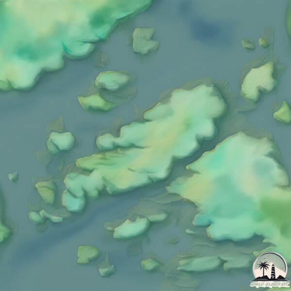
Geography and size of Baron
Size: 13.3 km²
Coastline: 40 km
Ocean: Pacific Ocean
Sea: The Coastal Waters of Southeast Alaska and British Columbia
Continent: North America
Baron is a Medium Island spanning 13 km² with a coastline of 40 km.
Archipel: –
Tectonic Plate: North America – Covers North America and parts of the Atlantic and Arctic Oceans, characterized by diverse geological features and varying levels of seismic activity.
The geographic heart of the island is pinpointed at these coordinates:
Latitude: 54.4681921 / Longitude: -130.81928929
Climate and weather of Baron
Climate Zone: Temperate
Climate Details: Temperate Oceanic Climate
Temperature: Warm Summer
Climate Characteristics: Known for its moderate year-round temperatures with ample rainfall and no dry season. Warm summers are characteristic.
Topography and nature of Baron
Timezone: UTC-08:00
Timezone places: America/Los_Angeles
Max. Elevation: 31 m
Mean Elevation: 15 m
Vegetation: Evergreen Needleleaf Forest
Tree Coverage: 79%
The mean elevation is 15 m. The highest elevation on the island reaches approximately 31 meters above sea level. The island is characterized by Plains: Flat, low-lying lands characterized by a maximum elevation of up to 200 meters. On islands, plains are typically coastal lowlands or central flat areas.
Dominating Vegetation: Evergreen Needleleaf Forest
Dominated by evergreen coniferous trees such as pines and firs, which retain their needle-like leaves throughout the year. These forests are often found in cooler climates. Baron has a tree cover of 79 %.
Vegetation: 5 vegetation zones – Highly Diverse Island
With five different vegetation zones, these islands offer a rich tapestry of ecosystems. The variety could include dense forests, open meadows, wetlands, coastal zones, and more. This level of diversity supports an intricate web of life, with each zone playing a vital role in the overall ecological health and balance of the island.
Infrastructure and Travelling to Baron
Does the island have a public airport? no.
There is no public and scheduled airport on Baron. The nearest airport is Prince Rupert Airport, located 44 km away.
Does the island have a major port? no.
There are no major ports on Baron. The closest major port is PORT SIMPSON, approximately 40 km away.
The mean population of Baron is 0 per km². Baron is Uninhabited. The island belongs to Canada.
Continuing your journey, Dunira is the next notable island, situated merely km away.
Can you Beat ARK: The Island in 10 Days?
Can you beat ALL 4 Island Bosses in just 10 Days? Only one way to find out... subscribe: ...Can you Beat ARK: The Island in 10 Days?
Can you beat ALL 4 Island Bosses in just 10 Days? Only one way to find ...
Can you beat ALL 4 Island Bosses in just 10 Days? Only one way to find out... subscribe: ...
Solo Taming EVERY Dino in ARK: The Island
In this video, I tame EVERY dino that exists on the Island.... (1/6 ...
In this video, I tame EVERY dino that exists on the Island.... (1/6 maps) This video also marks the beginning of my quest to tame ...
I Watched the One Piece HORROR Movie
This movie was creepy and had me on the edge of my seat #shorts ...
This movie was creepy and had me on the edge of my seat #shorts #onepiece #anime I Watched the One Piece HORROR Movie.
one piece’s most creepy moment| One Piece: Baron Omasturi and the Secret Island| #anime #onepiece
This made me cry so hard :baron omatsuri and the secret island #one piece #scary #fyp
The Baron (1966) EP16: The Island ¦ HD 1080p Restoration
Guest starring Dudley Sutton and Derek Newark. While being held on a ...
Guest starring Dudley Sutton and Derek Newark. While being held on a blacklisted freighter, Mannering and Cordelia discover ...
A Wolf At The Door | Island At War | Baron/Felicity
I wanted to vid this show for a loong time. Since I`ve watched it and ...
I wanted to vid this show for a loong time. Since I`ve watched it and for now I`m utterly in love with The Baron, who`s definetely one ...
😂Baron omatsuri and the secret island #onepiece #animemovie #anime
Nothing but an Illusion... / DJ Kappa / Baron Omatsuri and the secret Island / one piece / ORIGINAL
onepiece #onepieceedit.
onepiece #onepieceedit.
The One Piece HORROR Movie… (Baron Omatsuri and the Secret Island Analysis and Breakdown)
The Darkest One Piece has ever gotten is also one of the BEST parts of ...
The Darkest One Piece has ever gotten is also one of the BEST parts of the series. The 6th One Piece Movie, Baron Omatsuri and ...
In One Piece Movie 06 Baron Omatsuri and the Secret Island, the replicas of the Baron's #onepiece
In One Piece Movie 6: Baron Omatsuri and the Secret Island, the ...
In One Piece Movie 6: Baron Omatsuri and the Secret Island, the Baron's crew replicas don't know they're fake. The Lily Carnation ...
Onepiece: Baron Omatsuri and the Secret Island.#luffy#onepiece
Anime Name - One Piece Anime Studio -Toei Animation Song - Funk do ...
Anime Name - One Piece Anime Studio -Toei Animation Song - Funk do bounce (slowed) Editing App - Capcut Pro ...
Did the Baron Omatsuri Movie inspire the Thriller Bark Arc?
1 APP for Tracking your Anime! DOWNLOAD NOW! wwww.thewakuwaku.com We ...
1 APP for Tracking your Anime! DOWNLOAD NOW! wwww.thewakuwaku.com We are huge fans of Anime here and we will keep ...
Helicopter Invasion vs NEW Island Fortress Map Battle! | Ravenfield
Helicopter Infantry VS ISLAND FORTRESS Battle! | Ravenfield Welcome ...
Helicopter Infantry VS ISLAND FORTRESS Battle! | Ravenfield Welcome back to Ravenfield! Today I lead an impossible ...
Barren Island Andaman & Nicobar | Active Volcano of India | Andaman Islands | Andaman Travel Guide
Barren island is one and only island of India which is situated in ...
Barren island is one and only island of India which is situated in andaman. In this video you will know how to reach barren island, ...
Scuba Diving Baron Island
Scuba Diving out the back of Keppel Islands at Baron island 30m Down.
Scuba Diving out the back of Keppel Islands at Baron island 30m Down.
Barren Island Volcano 🌋 || India's only active volcano || Andaman and Nicobar #shorts #amazingfacts
Barren Island Volcano || India's only active volcano || Andaman and ...
Barren Island Volcano || India's only active volcano || Andaman and Nicobar Islands. #shorts.
one piece movie,secret island #onepiece #luffy
OnePiece… | Baron Omatsuri and the Secret Island | #onepiece
View from Barrow Island yesterday. Gnarly 😎
Movie: Baron Omatsuri and the Secret Island
One Piece Movie 6 OST Baron Omatsuri and the Secret Island 02 Baron Omatsuri Appears
My favorite One Piece movie. Baron omatsuri and the secret island #onepiece #anime #animemovie
You Won't Believe What We Found on Barren Island Andaman
Exploring the Mysterious Barren Island Andaman: Unveiling Hidden ...
Exploring the Mysterious Barren Island Andaman: Unveiling Hidden Wonders!❤️ Welcome to our channel! Join us on an ...
One Piece Movie 6 Edit⚠️flashing lights warning⚠️ #shorts #onepiece #edit
Song: PASTEL GHOST - SILHOUETTE (Slowed Perfection) Movie: One Piece: ...
Song: PASTEL GHOST - SILHOUETTE (Slowed Perfection) Movie: One Piece: Baron Omatsuri and the Secret Island.
Canada is classified as Developed region: G7: Group of Seven – Major advanced economies, including Canada, France, Germany, Italy, Japan, the United Kingdom, and the United States. The level of income is High income: OECD.
News – Latest Updates and Headlines from Baron
Stay informed with the most recent news and important headlines from Baron. Here’s a roundup of the latest developments.
Loading...
Please note: The data used here has been primarily extracted from satellite readings. Deviations from exact values may occur, particularly regarding the height of elevations and population density. Land area and coastline measurements refer to average values at mean high tide.