Welcome to Bhitarkanika, a Tropical island in the Bay of Bengal, part of the majestic Indian Ocean. This guide offers a comprehensive overview of what makes Bhitarkanika unique – from its geography and climate to its population, infrastructure, and beyond. Dive into the details:
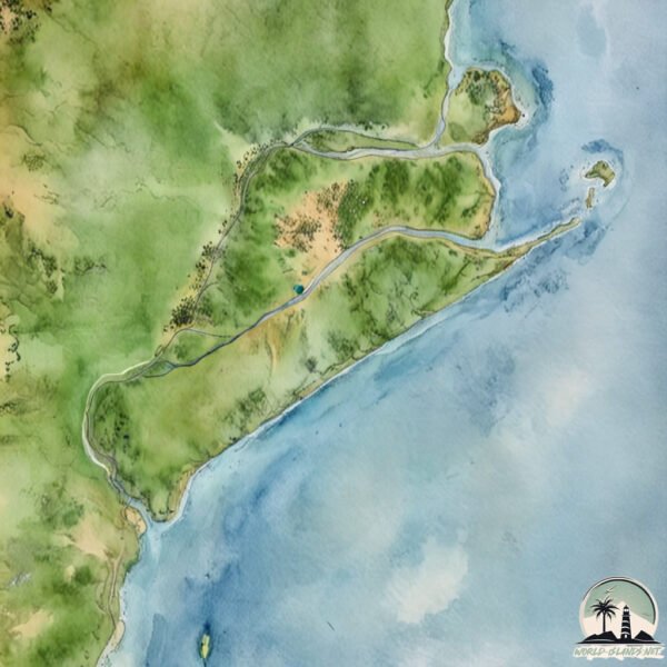
Geography and size of Bhitarkanika
Size: 431.8 km²
Coastline: 208.2 km
Ocean: Indian Ocean
Sea: Bay of Bengal
Continent: Asia
Bhitarkanika is a Large Island spanning 432 km² with a coastline of 208 km.
Archipel: –
Tectonic Plate: India – A major tectonic plate that initially moved northward at a rapid pace before colliding with the Eurasian Plate. This collision is responsible for the uplift of the Himalayas and the Tibetan Plateau.
The geographic heart of the island is pinpointed at these coordinates:
Latitude: 20.66114302 / Longitude: 86.86298761
Climate and weather of Bhitarkanika
Climate Zone: Tropical
Climate Details: Tropical Savanna, Wet
Temperature: Hot
Climate Characteristics: Defined by distinct wet and dry seasons with high temperatures year-round. Pronounced rainfall occurs during the wet season, while the dry season is marked by drought.
Topography and nature of Bhitarkanika
Timezone: UTC+05:30
Timezone places: Asia/Kolkata
Max. Elevation: 12 m
Mean Elevation: 4 m
Vegetation: Wetland
Tree Coverage: 29%
The mean elevation is 4 m. The highest elevation on the island reaches approximately 12 meters above sea level. The island is characterized by Plains: Flat, low-lying lands characterized by a maximum elevation of up to 200 meters. On islands, plains are typically coastal lowlands or central flat areas.
Dominating Vegetation: Wetland
These areas are saturated with water, either permanently or seasonally, and support aquatic plants. Wetlands are important for biodiversity and water filtration. Bhitarkanika has a tree cover of 29 %.
Vegetation: 16 vegetation zones – Exceptionally Diverse Island
Islands with more than ten vegetation zones are among the most ecologically rich and varied in the world. These islands are akin to miniature continents, boasting an incredible array of ecosystems. The sheer range of habitats, from high peaks to deep valleys, rainforests to deserts, creates a mosaic of life that is unparalleled. They are crucial for conservation and ecological studies.
Infrastructure and Travelling to Bhitarkanika
Does the island have a public airport? no.
There is no public and scheduled airport on Bhitarkanika. The nearest airport is Biju Patnaik Airport, located 105 km away.
Does the island have a major port? no.
There are no major ports on Bhitarkanika. The closest major port is PARADIP, approximately 28 km away.
The mean population of Bhitarkanika is 381 per km². Bhitarkanika is Moderately Inhabited. The island belongs to India.
Continuing your journey, Chellikulia is the next notable island, situated merely km away.
Inside India's Second Largest Mangrove Wetland: Bhitarkanika |I Love My Odisha Ep 6|Curly Tales
Odisha is also home to India's second-largest mangrove wetland called Bhitarkanika Mangroves. Bhitarkanika National Park is ...Inside India's Second Largest Mangrove Wetland: Bhitarkanika |I Love My Odisha Ep 6|Curly Tales
Odisha is also home to India's second-largest mangrove wetland called ...
Odisha is also home to India's second-largest mangrove wetland called Bhitarkanika Mangroves. Bhitarkanika National Park is ...
EP 03 - Exploring a Secret Island Beyond Bhitarkanika’s Jungles
After exploring the crocodile-filled jungles of Bhitarkanika, I ...
After exploring the crocodile-filled jungles of Bhitarkanika, I ventured beyond into the sea, towards an island few have ever seen.
Ep 2 Bhitarkanika Wildlife Sanctuary, Odisha | Mangrove forests | Jungle Safari | North Odisha
Bhitarkanika Wildlife Sanctuary and National Park is known as the ...
Bhitarkanika Wildlife Sanctuary and National Park is known as the Mini-Amazon of India. Lying on the coast of Bay of Bengal, it is ...
Habalikhati Nature Camp Bhitarkanika | Habalikhati Sea Beach | A Thrilling Adventure ✨️
Are you planning a thrilling trip with your gang? then Enjoy a day in ...
Are you planning a thrilling trip with your gang? then Enjoy a day in this Secret Island Habalikhati Nature Camp Bhitarkanika with ...
Exploring Bhitarkanika National Park | India’s Mangrove Wildlife | Odisha
Experience the wild beauty of Bhitarkanika National Park, Odisha, one ...
Experience the wild beauty of Bhitarkanika National Park, Odisha, one of India's most unique and biodiverse wildlife destinations.
big#Crocodile#Big#Crocodile#Bhitarkanika national park boot sarvice call me 7815078402
EP 01 - Living Inside India’s Amazon | Bhitarkanika Crocodile Safari with Antara Cruise
Join me on a rare journey into Bhitarkanika, the Amazon of India. A ...
Join me on a rare journey into Bhitarkanika, the Amazon of India. A mangrove forest home to giant saltwater crocodiles and ...
Bhitarkanika Tour Plan | Bhitarkanika National Park | Dangamal Nature Camp Dangamal Eco Tourism
Bhitarkanika Tour Plan | Bhitarkanika National Park | Dangamal Nature ...
Bhitarkanika Tour Plan | Bhitarkanika National Park | Dangamal Nature Camp | Dangamal Eco Tourism I Chandbali Jetty | Odisha ...
Born Wild: Preserving Odisha's Bhitarkanika Mangroves (Aired: February 2006)
The Bhitarkanika in Odisha are India's second largest Mangroves, after ...
The Bhitarkanika in Odisha are India's second largest Mangroves, after the Sundarbans. At one time, most of Odisha's coast was ...
Bhitarakanika National Park | Bhitarkanika Kendrapada | Bhitarkanika Crocodile 🐊 | Odisha Tourism |
Bhitarkanika: Kanika island. Very well protected mangrove forest, famous for Salt Water Crocodile.
Bhitarkanika National Park || Wildlife Sanctuary || Odisha
Bhitarkanika #Odisha #odishatourism Bhitarkanika National Park | ...
Bhitarkanika #Odisha #odishatourism Bhitarkanika National Park | Wildlife Sanctuary | Odisha The Amazon of India bhitarkanika ...
Bhitarakanika – Odisha’s Hidden Amazon! 🐊 #bhitarkanika #odishatourism #odia
Bhitarkanika National Park | India's 2nd Largest Mangrove Wetland | Kanika Island | Odisha Tour EP 1
In this video we have explored Bhitarkanika National Park. We have ...
In this video we have explored Bhitarkanika National Park. We have shown how to reach Bhitarkanika , where to stay , what to eat ...
🐊 at Bhitarkanika National Park, Odisha..#odisha #odishatourism #bhitarkanika
Bhitarkanika National park | Map in Short l Amrit Upadhyay | UPSC 2024 l StudyIQ IAS Hindi
mapinshort #studyiqiashindi #amrit_upadhyay Spread in a vast are of ...
mapinshort #studyiqiashindi #amrit_upadhyay Spread in a vast are of 672 Kms Bhitarkanika Indian Wildlife Sanctuary Orissa is ...
EP 02 - India’s Hidden Amazon: Searching for 20-Foot Crocodiles
I spent two days living on a boat inside India's wildest mangrove ...
I spent two days living on a boat inside India's wildest mangrove forest searching for the legendary giant crocodiles of ...
Saltwater Crocodile in Bhitarkanika National Park #BhitarkanikaNationalPark #saltwatercrocodile
Saltwater Crocodile in Bhitarkanika National Park #Bhitarkanikatour ...
Saltwater Crocodile in Bhitarkanika National Park #Bhitarkanikatour #BhitarkanikaNationalPark #Bhitarkanika #habalikhati ...
কোলকাতা থেকে ২ রাত / ৩ দিনে ঘুরে আসুন এই জায়গা | Bhitarkanika Wildlife Sanctuary
Bhitarkanika Wildlife Sanctuary | bhitarkanika crocodile | weekend ...
Bhitarkanika Wildlife Sanctuary | bhitarkanika crocodile | weekend forest trip from kolkata | jungle camp near kolkata | jungle tent ...
India’s Wildest Boat Ride - Exploring Bhitarkanika with Antara Cruise
This is the beginning of my journey into Bhitarkanika, a land of ...
This is the beginning of my journey into Bhitarkanika, a land of mangroves, crocodiles, and untold wilderness. Join me as I explore ...
BhitarKanika - Habalikati Island
Glimpse of the Habalikati Island trip in Bhitarkanika National Park on ...
Glimpse of the Habalikati Island trip in Bhitarkanika National Park on February 2018.
Bhitarkanika National park l Map in Short l Amrit Upadhyay UPSC 2024 l StudyIQ IAS
Spread in a vast are of 672 Kms Bhitarkanika Indian Wildlife Sanctuary ...
Spread in a vast are of 672 Kms Bhitarkanika Indian Wildlife Sanctuary Orissa is the 2nd largest Mangrove ecosystems of India.
Welcome to Bhitarkanika National Park in Odisha Wildlife mangrove forest. Call 9777523351
Nature trail at Bhitarkanika National Park #adventure #travel #odisha #wildlife #crocodile #forest
India is classified as Emerging region: BRIC: Brazil, Russia, India, and China – Economies noted for their rapid growth and increasing influence on global affairs. The level of income is Lower middle income.
News – Latest Updates and Headlines from Bhitarkanika
Stay informed with the most recent news and important headlines from Bhitarkanika. Here’s a roundup of the latest developments.
Loading...
Please note: The data used here has been primarily extracted from satellite readings. Deviations from exact values may occur, particularly regarding the height of elevations and population density. Land area and coastline measurements refer to average values at mean high tide.