Bradford
Welcome to Bradford, a Temperate island in the North Pacific Ocean, part of the majestic Pacific Ocean. This guide offers a comprehensive overview of what makes Bradford unique – from its geography and climate to its population, infrastructure, and beyond. Dive into the details:
- Geography and Size: Explore the island’s size and location.
- Climate and Weather: Weather patterns and temperature.
- Topography and Nature: Uncover the natural wonders of the island.
- Infrastructure and Travelling: Insights on reaching, staying, and making the most of your visit.
- News and Headlines: Latest News.
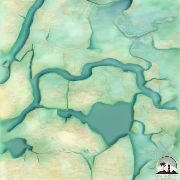
Geography and size of Bradford
Size: 32 km²
Coastline: 37.2 km
Ocean: Pacific Ocean
Sea: North Pacific Ocean
Continent: North America
Bradford is a Medium Island spanning 32 km² with a coastline of 37 km.
Archipel: –
Tectonic Plate: North America – Covers North America and parts of the Atlantic and Arctic Oceans, characterized by diverse geological features and varying levels of seismic activity.
The geographic heart of the island is pinpointed at these coordinates:
Latitude: 38.07656589 / Longitude: -121.62697492
Climate and weather of Bradford
Climate Zone: Temperate
Climate Details: Hot-Summer Mediterranean Climate
Temperature: Hot Summer
Climate Characteristics: Characterized by hot, dry summers and mild, wet winters, typical of coastal areas with abundant sunshine.
Topography and nature of Bradford
Timezone: UTC-08:00
Timezone places: America/Los_Angeles
Max. Elevation: -2 m
Mean Elevation: -5 m
Vegetation: Cultivated Land
Tree Coverage: 27%
The mean elevation is -5 m. Remarkably, this unique island barely emerges above the sea level, showcasing nature’s fascinating interplay with the ocean. The island is characterized by Plains: Flat, low-lying lands characterized by a maximum elevation of up to 200 meters. On islands, plains are typically coastal lowlands or central flat areas.
Dominating Vegetation: Cultivated Land
Areas dedicated to agricultural activities, growing crops like grains, vegetables, and fruits. These lands are usually human-modified landscapes. Bradford has a tree cover of 27 %.
Vegetation: 13 vegetation zones – Exceptionally Diverse Island
Islands with more than ten vegetation zones are among the most ecologically rich and varied in the world. These islands are akin to miniature continents, boasting an incredible array of ecosystems. The sheer range of habitats, from high peaks to deep valleys, rainforests to deserts, creates a mosaic of life that is unparalleled. They are crucial for conservation and ecological studies.
Infrastructure and Travelling to Bradford
Does the island have a public airport? no.
There is no public and scheduled airport on Bradford. The nearest airport is Sacramento Mather Airport, located 60 km away.
Does the island have a major port? no.
There are no major ports on Bradford. The closest major port is RIO VISTA, approximately 7 km away.
The mean population of Bradford is 0 per km². Bradford is Uninhabited. The island belongs to United States of America.
Continuing your journey, Mandeville is the next notable island, situated merely km away.
Bradford Island


United States of America is classified as Developed region: G7: Group of Seven – Major advanced economies, including Canada, France, Germany, Italy, Japan, the United Kingdom, and the United States. The level of income is High income: OECD.
News – Latest Updates and Headlines from Bradford
Stay informed with the most recent news and important headlines from Bradford. Here’s a roundup of the latest developments.
Please note: The data used here has been primarily extracted from satellite readings. Deviations from exact values may occur, particularly regarding the height of elevations and population density. Land area and coastline measurements refer to average values at mean high tide.