Welcome to Canning, a Polar island in the South Pacific Ocean, part of the majestic Pacific Ocean. This guide offers a comprehensive overview of what makes Canning unique – from its geography and climate to its population, infrastructure, and beyond. Dive into the details:
Geography and size of Canning
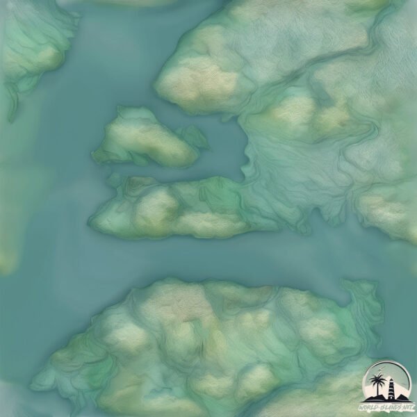
Size: 36.1 km²
Coastline: 81.6 km
Ocean: Pacific Ocean
Sea: South Pacific Ocean
Continent: South America
Canning is a Medium Island spanning 36 km² with a coastline of 82 km.
Archipel: Cordillera Patagónica Insular – A series of islands in the Patagonian region, known for their dramatic landscapes and part of the Andean mountain range.
Tectonic Plate: South America – A major plate covering the South American continent and part of the Atlantic Ocean, known for the Andes mountain range and significant seismic and volcanic activity.
The geographic heart of the island is pinpointed at these coordinates:
Latitude: -50.29863076 / Longitude: -74.66947276
Climate and weather of Canning
Climate Zone: Polar
Climate Details: Tundra
Temperature: Cold
Climate Characteristics: The tundra climate features long, extremely cold winters and short, cool summers. Vegetation is limited to mosses, lichens, and small shrubs due to the low temperatures and short growing seasons. Biodiversity is low, but some specialized species thrive.
Topography and nature of Canning
Timezone: UTC-04:00
Timezone places: America/La_Paz
Max. Elevation: 382 m
Mean Elevation: 130 m
Vegetation: Evergreen Broadleaf Forest
Tree Coverage: 89%
The mean elevation is 130 m. The highest elevation on the island reaches approximately 382 meters above sea level. The island is characterized by Hills: Gently sloping landforms with rounded tops, having a maximum elevation between 200 and 500 meters. Hills contribute to a varied landscape on islands.
Dominating Vegetation: Evergreen Broadleaf Forest
Characterized by dense, lush canopies of broadleaf trees that retain their leaves year-round. These forests are typically found in tropical and subtropical regions and are known for their high biodiversity. Canning has a tree cover of 89 %.
Vegetation: 6 vegetation zones – Very Highly Diverse Island
Islands in this range are ecological powerhouses, showcasing a wide array of vegetation zones. Each zone, from lush rainforests to arid scrublands, coastal mangroves to mountainous regions, contributes to a complex and interdependent ecosystem. These islands are often hotspots of biodiversity, supporting numerous species and intricate ecological processes.
Infrastructure and Travelling to Canning
Does the island have a public airport? no.
There is no public and scheduled airport on Canning. The nearest airport is Lieutenant Julio Gallardo Airport, located 274 km away.
Does the island have a major port? no.
There are no major ports on Canning. The closest major port is PUERTO NATALES, approximately 273 km away.
The mean population of Canning is 1 per km². Canning is Uninhabited. The island belongs to Chile.
Continuing your journey, Nuestra Senora de la Esperanza is the next notable island, situated merely km away.
~Canning Rum Island Butter~
It's a tropical vacation in a jar! No . . . it's "BOB MARLEY" in a jar! It's taking peanut butter sandwiches to a whole new level.~Canning Rum Island Butter~
It's a tropical vacation in a jar! No . . . it's "BOB MARLEY" in a ...
It's a tropical vacation in a jar! No . . . it's "BOB MARLEY" in a jar! It's taking peanut butter sandwiches to a whole new level.
Brand New 1 Bedroom to rent London City Island Canning Town with Pool, Gym, Jacuzzi
Defoe House, London City Island 123 City Island Way E14 0TU - Brand ...
Defoe House, London City Island 123 City Island Way E14 0TU - Brand New Apartment, just completed Please advise if you are ...
City Island, Canning Town
Cycleway Recorded September 2022.
Cycleway Recorded September 2022.
London City Island (Canning Town) : 提供1 3 房河畔公寓新地標
London City Island (Canning Town) 倫敦島嶼生活社區,毗鄰國際金融中心Canary Wharf ...
London City Island (Canning Town) 倫敦島嶼生活社區,毗鄰國際金融中心Canary Wharf (金絲雀碼頭) 步行2分鐘到Canning ...
LONDON ISLAND ep 2 - THE HOMELESS LONDONERS outside Canning Town BEAUTIFUL APARTMENTS
The Homeless living under the bridge in the best transforming ...
The Homeless living under the bridge in the best transforming neighbourhood of Canning Town of east London. London Island ...
Ultraconvenient 2-Bedroom Flat for Rent | City Island Way, Canning Town, E14 | RentLondonFlat.com
Brand new and spacious two-bedroom apartment with wonderful balcony ...
Brand new and spacious two-bedroom apartment with wonderful balcony overlooking the River Thames, set on the 11th floor in ...
My Favorite Tinned Seafood #seafood #tinnedfish #ranking
Here’s Why Tuna Says DO NOT DRAIN!! #food #health #eat
1. Canning Town - view from City Island to Brunel Street Works
This view clearly shows the existing Brunel Street Works buildings, ...
This view clearly shows the existing Brunel Street Works buildings, across Bow Creek.
Have you ever wondered how #sardines are canned? #portugal #seafood
Business Insider tells you all you need to know about business, ...
Business Insider tells you all you need to know about business, finance, tech, retail, and more. Visit our homepage for the top ...
Canning the Chanterelle Harvest from Foraging during Hunting on Vancouver Island
I was blessed with a bounty of Chanterelle Mushrooms which I foraged ...
I was blessed with a bounty of Chanterelle Mushrooms which I foraged while out hunting. This video shows the process I do to ...
The canning class was a success!Music cred: Music: Island Joy Musician: David Godfrey
I Tried Tinned Clams…Again #seafood #tinnedfish #clams
best LONDON ISLAND LONDON NIGHTLIFE EID PARTY velly of CANNING TOWN
LONDON ISLAND LONDON NIGHTLIFE EID PARTY velly of CANNING TOWN.
LONDON ISLAND LONDON NIGHTLIFE EID PARTY velly of CANNING TOWN.
Fresh Anchovies
shorts #anchovies #fried.
shorts #anchovies #fried.
New island In Canning || New Travel Destination In Canning || Adventure Trip In Canning River ||
New island In Canning || New Travel Destination In Canning || ...
New island In Canning || New Travel Destination In Canning || Adventure Trip In Canning River || Yesterday we went Canning ...
2. Canning Town - view from City Island to Brunel Street Works
This view is across Bow Creeek to the site. You can clearly see the ...
This view is across Bow Creeek to the site. You can clearly see the Limmo Peninsula to the front and the Brunel Street Works ...
cook your canned sardines
Canning Conveyor - Sports Relief 2020 with Blue Peter and Love Island Winners
For more information about our what we provide to the film, TV and ...
For more information about our what we provide to the film, TV and entertainment industry contact ...
Bow creek island through the Canning Town station. Very beautiful view. London. #goviral #england
Trying canned scallops…#tinnedfish #tinnedscallops #seafood
City 🏙 Island, Canning Town, London. #cityisland #canningtown #londonlifestyle #travel #travel
2 bedroom(s) City Island Way, Canning town, E14 | Benham & Reeves
This modern apartment is set in Corson House, close to the floor ...
This modern apartment is set in Corson House, close to the floor bridge for the Jubilee line, part of the London City Island ...
COPYCAT Original Coney Island Hot Dog Meat Chili Sauce Recipe
This copycat Coney Island hot dog meat sauce recipe is so easy and ...
This copycat Coney Island hot dog meat sauce recipe is so easy and delicious. The chili meat sauce has a nice fine texture and a ...
Coral Island future update!!!!
Coral Island BIG update alert! Update 1.2b & 1.3 are on the way. Who's ...
Coral Island BIG update alert! Update 1.2b & 1.3 are on the way. Who's ready for this? Full roadmap → check the new Dev Blog ...
Chile is classified as Emerging region: G20: Group of Twenty – Major economies comprising both developed and emerging countries, representing the world’s largest economies. The level of income is Upper middle income.
News – Latest Updates and Headlines from Canning
Stay informed with the most recent news and important headlines from Canning. Here’s a roundup of the latest developments.
Loading...
Please note: The data used here has been primarily extracted from satellite readings. Deviations from exact values may occur, particularly regarding the height of elevations and population density. Land area and coastline measurements refer to average values at mean high tide.