Cape Breton
Welcome to Cape Breton, a Continental island in the Gulf of St. Lawrence, part of the majestic Atlantic Ocean. This guide offers a comprehensive overview of what makes Cape Breton unique – from its geography and climate to its population, infrastructure, and beyond. Dive into the details:
- Geography and Size: Explore the island’s size and location.
- Climate and Weather: Weather patterns and temperature.
- Topography and Nature: Uncover the natural wonders of the island.
- Infrastructure and Travelling: Insights on reaching, staying, and making the most of your visit.
- News and Headlines: Latest News.
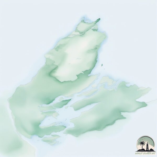
Geography and size of Cape Breton
Size: 10513 km²
Coastline: 2167 km
Ocean: Atlantic Ocean
Sea: Gulf of St. Lawrence
Continent: North America
Cape Breton is a Giant Island spanning 10513 km² with a coastline of 2167 km.
Archipel: –
Tectonic Plate: North America – Covers North America and parts of the Atlantic and Arctic Oceans, characterized by diverse geological features and varying levels of seismic activity.
The geographic heart of the island is pinpointed at these coordinates:
Latitude: 46.17321679 / Longitude: -60.73617889
Climate and weather of Cape Breton
Climate Zone: Continental
Climate Details: Warm-Summer Humid Continental Climate
Temperature: Warm Summer
Climate Characteristics: Features warm summers and cold winters with consistent precipitation, common in higher latitudes.
Topography and nature of Cape Breton
Timezone: UTC-04:00
Timezone places: America/La_Paz
Max. Elevation: 525 m
Mean Elevation: 169 m
Vegetation: Mixed Forest
Tree Coverage: 71%
The mean elevation is 169 m. The highest elevation on the island reaches approximately 525 meters above sea level. The island is characterized by Plateau: Elevated flatlands rising sharply above the surrounding area, with a maximum elevation over 500 meters but a mean elevation less than 300 meters, forming unique highland areas on islands.
Dominating Vegetation: Mixed Forest
A combination of both deciduous and evergreen trees, often found in transitional zones between forest types. These forests offer a diverse habitat for various wildlife species. Cape Breton has a tree cover of 71 %.
Vegetation: 14 vegetation zones – Exceptionally Diverse Island
Islands with more than ten vegetation zones are among the most ecologically rich and varied in the world. These islands are akin to miniature continents, boasting an incredible array of ecosystems. The sheer range of habitats, from high peaks to deep valleys, rainforests to deserts, creates a mosaic of life that is unparalleled. They are crucial for conservation and ecological studies.
Infrastructure and Travelling to Cape Breton
Does the island have a public airport? yes.
Cape Breton has a public and scheduled airport. The following airports are located on this island: Sydney / J.A. Douglas McCurdy Airport.
Does the island have a major port? yes.
Cape Breton is home to a major port. The following ports are situated on the island: SYDNEY, PORT HAWKESBURY, PORT HASTINGS, WHYCOCOMAGH, GRAND NARROWS, NORTH SYDNEY.
The mean population of Cape Breton is 12 per km². Cape Breton is Gently Populated. The island belongs to Canada.
The name of the island resonates across different cultures and languages. Here is how it is known around the world: Arabic: جزيرة كيب بريتون; German: Kap-Breton-Insel; Spanish: Isla del Cabo Bretón; French: île du Cap-Breton; Portuguese: Ilha Cape Breton; Russian: Кейп-Бретон; Chinese: 布雷顿角岛
Continuing your journey, Janvrin Island is the next notable island, situated merely km away.
Exploring the World-Famous Cabot Trail & Cape Breton Island: a Travel Guide


Canada is classified as Developed region: G7: Group of Seven – Major advanced economies, including Canada, France, Germany, Italy, Japan, the United Kingdom, and the United States. The level of income is High income: OECD.
News – Latest Updates and Headlines from Cape Breton
Stay informed with the most recent news and important headlines from Cape Breton. Here’s a roundup of the latest developments.
Social Media Posts about Cape Breton
Please note: The data used here has been primarily extracted from satellite readings. Deviations from exact values may occur, particularly regarding the height of elevations and population density. Land area and coastline measurements refer to average values at mean high tide.