Welcome to Dublar Char, a Tropical island in the Bay of Bengal, part of the majestic Indian Ocean. This guide offers a comprehensive overview of what makes Dublar Char unique – from its geography and climate to its population, infrastructure, and beyond. Dive into the details:
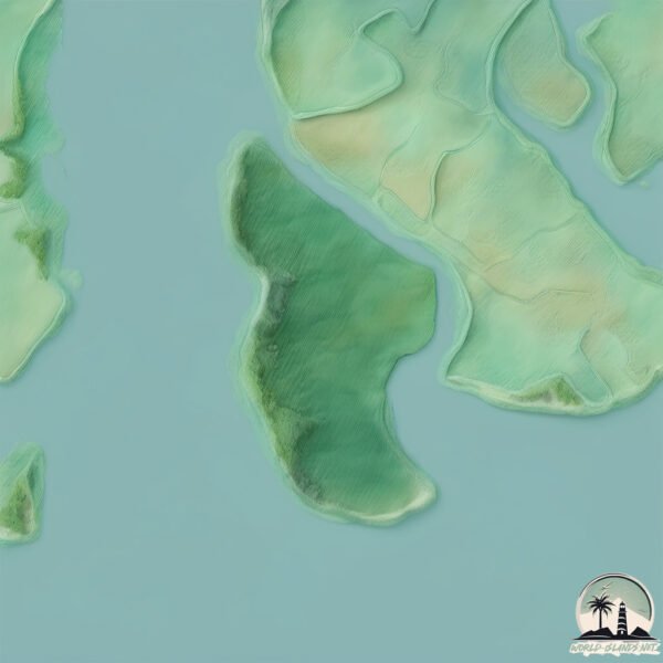
Geography and size of Dublar Char
Size: 68.6 km²
Coastline: 72.5 km
Ocean: Indian Ocean
Sea: Bay of Bengal
Continent: Asia
Dublar Char is a Medium Island spanning 69 km² with a coastline of 72 km.
Archipel: –
Tectonic Plate: India – A major tectonic plate that initially moved northward at a rapid pace before colliding with the Eurasian Plate. This collision is responsible for the uplift of the Himalayas and the Tibetan Plateau.
The geographic heart of the island is pinpointed at these coordinates:
Latitude: 21.77849789 / Longitude: 89.5679082
Climate and weather of Dublar Char
Climate Zone: Tropical
Climate Details: Tropical Monsoon Climate
Temperature: Hot
Climate Characteristics: Characterized by heavy rainfall, high humidity, and uniformly high temperatures, but with a distinct short dry season. It features a seasonal reversal of prevailing wind directions.
Topography and nature of Dublar Char
Timezone: UTC+06:00
Timezone places: Asia/Dhaka
Max. Elevation: 13 m
Mean Elevation: 8 m
Vegetation: Mangrove Forest
Tree Coverage: 54%
The mean elevation is 8 m. The highest elevation on the island reaches approximately 13 meters above sea level. The island is characterized by Plains: Flat, low-lying lands characterized by a maximum elevation of up to 200 meters. On islands, plains are typically coastal lowlands or central flat areas.
Dominating Vegetation: Mangrove Forest
Found in coastal areas and river deltas, these unique wetland ecosystems are adapted to saline conditions and are crucial for coastal protection and biodiversity. Dublar Char has a tree cover of 54 %.
Vegetation: 6 vegetation zones – Very Highly Diverse Island
Islands in this range are ecological powerhouses, showcasing a wide array of vegetation zones. Each zone, from lush rainforests to arid scrublands, coastal mangroves to mountainous regions, contributes to a complex and interdependent ecosystem. These islands are often hotspots of biodiversity, supporting numerous species and intricate ecological processes.
Infrastructure and Travelling to Dublar Char
Does the island have a public airport? no.
There is no public and scheduled airport on Dublar Char. The nearest airport is Barisal Airport, located 135 km away.
Does the island have a major port? no.
There are no major ports on Dublar Char. The closest major port is MONGLA, approximately 69 km away.
The mean population of Dublar Char is 92 per km². Dublar Char is Gently Populated. The island belongs to Bangladesh.
Continuing your journey, Tinkona is the next notable island, situated merely km away.
DUBLAR CHAR SUNDARBAN দুবলার চর, সুন্দরবন
Dublar Char Island The Sundarban is one of the biggest single block of tidal halophytic mangrove forest in the world. It is located ...DUBLAR CHAR SUNDARBAN দুবলার চর, সুন্দরবন
Dublar Char Island The Sundarban is one of the biggest single block of ...
Dublar Char Island The Sundarban is one of the biggest single block of tidal halophytic mangrove forest in the world. It is located ...
Amazing Sunset Moment At Dublar Char (দুব্লার চর) Island
Video Location : Dublar Char Island Video Device : Sony HDR CX-405 ...
Video Location : Dublar Char Island Video Device : Sony HDR CX-405 Music : At Rest - Romance by Kevin MacLeod is licensed ...
Dublar char journey 2024| Sundarban |Bangladesh |Beauty of sea water |
Dublar Char Journey 2024 | Sundarbans | Beauty of the Sea | ...
Dublar Char Journey 2024 | Sundarbans | Beauty of the Sea | Bangladesh* Embark on an unforgettable *Dublar Char ...
The Most Dangerous And Overloaded Taller Journey At Bongoposagor, Dublar Char (Must See)
The Most Dangerous And Overloaded Taller Journey At Bongoposagor, ...
The Most Dangerous And Overloaded Taller Journey At Bongoposagor, Dublar Char (Must See) The bay of bengal the largest ...
Dublar Char Cinematic – A Forgotten Island of Beauty
Welcome to Dublar Char — an untouched island nestled at the edge of ...
Welcome to Dublar Char — an untouched island nestled at the edge of the Sundarbans, where time slows down and nature ...
Dublar char island in Sunderbans
Here I tried to showcase Dublar Char, which is an island in Bangladesh ...
Here I tried to showcase Dublar Char, which is an island in Bangladesh with an area of 66.5 km², located in the Bagerhat District ...
Fishing at Dublar char || story of fishing person || in dublar char
Salt and fresh water meet in a vast Ganges Delta where the Ganges, ...
Salt and fresh water meet in a vast Ganges Delta where the Ganges, Brahmaputra and Meghna rivers join the Bay of Bengal.
Amazing Natural Beauty Of Dublar Char Island - দুবলার চর দ্বীপ এর আশ্চর্যজনক প্রাকৃতিক সৌন্দর্য
Natural Beauty Of Dublar Char Dublar Char is an Island of Bangladesh. ...
Natural Beauty Of Dublar Char Dublar Char is an Island of Bangladesh. It is situated beside the Sundarban and The ...
Beauty Of Dublar Char Island Market At Night, Sundarban
Dublar Char Island Market At Night Location : Dublar Char, Sundarban ...
Dublar Char Island Market At Night Location : Dublar Char, Sundarban Video Device : Handycam cx405 Dublar char is a little ...
Dublar Char: Discovering Bangladesh's Hidden River Island Paradise #travel #naturelover #facts
Explore the serene beauty of Dublar Char, a hidden gem in Bangladesh's ...
Explore the serene beauty of Dublar Char, a hidden gem in Bangladesh's Noakhali district. This unique river island, shaped by the ...
dublar char sundarban - দুবলার চর সুন্দরবন
Exclusive video of Rash Fair.
Exclusive video of Rash Fair.
Dublar Char - দুবলার চর - জেলে পল্লী- Sundarbans - সুন্দরবন – Most Beautiful Place in Bangladesh.
Dublar Char is an island in Bangladesh with an area of 66.5 km², ...
Dublar Char is an island in Bangladesh with an area of 66.5 km², located in the Bagerhat District of the Khulna Division. Dublar ...
Life at Dublar char Island
A walking adventure at "High Way" inside Dublar Char island
High Way Of Dublar Char Location : Dublar Char Video Device : Sony ...
High Way Of Dublar Char Location : Dublar Char Video Device : Sony Handycam cx405 Dublar Char is a beautiful island in the ...
শুটকীর রাজ্য - দুবলার চর
Dublar Char is an island in the Sundarbans of Bangladesh. Here live a ...
Dublar Char is an island in the Sundarbans of Bangladesh. Here live a lot of fisherman for six months. Fishing is their job.
Dublar Char !
Dublar Char ! Dublar Char is an island in Bangladesh with an area of ...
Dublar Char ! Dublar Char is an island in Bangladesh with an area of 66.5 km², located in the Bagerhat District of the Khulna ...
Dubla Island | Sundarbans #mohsin_ul_hakim
Sundarban Bangladesh || দুবলার চর সুন্দরবন || Dublar Char || Travel Sundarban 2019
Sundarban#Dublar Char# Sundarbans is one of the many beautiful, most ...
Sundarban#Dublar Char# Sundarbans is one of the many beautiful, most visited places in the region, one of the areas of the ...
খুলনা থেকে দুবলার চর ভ্রমণ!দুবলার চর সুন্দরবন! Dublar Char! Sunderban Tour 2025
খুলনা থেকে দুবলার চর ভ্রমণ!দুবলার চর সুন্দরবন! Dublar Char! Sunderban ...
খুলনা থেকে দুবলার চর ভ্রমণ!দুবলার চর সুন্দরবন! Dublar Char! Sunderban Tour 2025 ...
Dublar Char #sundarban #island #viral #adventure #morning #reels #mrbeast #trending #nature #singer
Dubla Island | দুবলার চর | সুন্দরবন
Dublar Char - দুবলার চর - Sundarbans - সুন্দরবন - Beautiful Place in Bangladesh
Dublar char is one f the best beautiful place in Bangladesh. If you ...
Dublar char is one f the best beautiful place in Bangladesh. If you want to enjoy the beauty of nature then this place will be the ...
Stunning Ocean Waves Sounds At Dublar Char Island
Video Location : Dublar Char Island, Sundarbans, Bangladesh Video ...
Video Location : Dublar Char Island, Sundarbans, Bangladesh Video Device : Sony HDR CX - 405.
Towards Dublar Char !
Towards Dublar Char ! Dublar Char is an island in Bangladesh, located ...
Towards Dublar Char ! Dublar Char is an island in Bangladesh, located in the Bagerhat District of the Khulna Division. [Dublar ...
Bangladesh is classified as Least developed region: Countries that exhibit the lowest indicators of socioeconomic development, with the lowest Human Development Index ratings. The level of income is Low income.
News – Latest Updates and Headlines from Dublar Char
Stay informed with the most recent news and important headlines from Dublar Char. Here’s a roundup of the latest developments.
Loading...
Please note: The data used here has been primarily extracted from satellite readings. Deviations from exact values may occur, particularly regarding the height of elevations and population density. Land area and coastline measurements refer to average values at mean high tide.