Dumaran
Welcome to Dumaran, a Tropical island in the Sulu Sea, part of the majestic Pacific Ocean. This guide offers a comprehensive overview of what makes Dumaran unique – from its geography and climate to its population, infrastructure, and beyond. Dive into the details:
- Geography and Size: Explore the island’s size and location.
- Climate and Weather: Weather patterns and temperature.
- Topography and Nature: Uncover the natural wonders of the island.
- Infrastructure and Travelling: Insights on reaching, staying, and making the most of your visit.
- News and Headlines: Latest News.
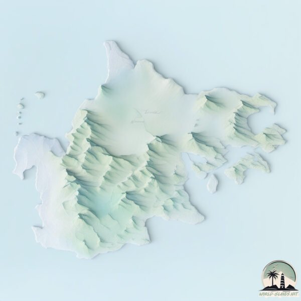
Geography and size of Dumaran
Size: 330.1 km²
Coastline: 168.7 km
Ocean: Pacific Ocean
Sea: Sulu Sea
Continent: Asia
Dumaran is a Large Island spanning 330 km² with a coastline of 169 km.
Archipel: Malay Archipelago – The world’s largest archipelago, located between mainland Southeast Asia and Australia, known for its immense biodiversity and cultural diversity.
Tectonic Plate: Sunda – Extends across Southeast Asia, encompassing parts of the Sunda Shelf, known for its interaction with the Australian Plate, contributing to volcanic activity in Indonesia.
The geographic heart of the island is pinpointed at these coordinates:
Latitude: 10.54063654 / Longitude: 119.86226243
Climate and weather of Dumaran
Climate Zone: Tropical
Climate Details: Tropical Monsoon Climate
Temperature: Hot
Climate Characteristics: Characterized by heavy rainfall, high humidity, and uniformly high temperatures, but with a distinct short dry season. It features a seasonal reversal of prevailing wind directions.
Topography and nature of Dumaran
Timezone: UTC+08:00
Timezone places: Australia/Perth
Max. Elevation: 111 m
Mean Elevation: 31 m
Vegetation: Agricultural Mosaic
Tree Coverage: 30%
The mean elevation is 31 m. The highest elevation on the island reaches approximately 111 meters above sea level. The island is characterized by Plains: Flat, low-lying lands characterized by a maximum elevation of up to 200 meters. On islands, plains are typically coastal lowlands or central flat areas.
Dominating Vegetation: Agricultural Mosaic
A mix of cropland and natural vegetation, often seen in rural landscapes where agricultural fields are interspersed with patches of natural habitats. Dumaran has a tree cover of 30 %.
Vegetation: 11 vegetation zones – Exceptionally Diverse Island
Islands with more than ten vegetation zones are among the most ecologically rich and varied in the world. These islands are akin to miniature continents, boasting an incredible array of ecosystems. The sheer range of habitats, from high peaks to deep valleys, rainforests to deserts, creates a mosaic of life that is unparalleled. They are crucial for conservation and ecological studies.
Infrastructure and Travelling to Dumaran
Does the island have a public airport? no.
There is no public and scheduled airport on Dumaran. The nearest airport is San Vicente Airport, located 52 km away.
Does the island have a major port? no.
There are no major ports on Dumaran. The closest major port is PUERTO PRINCESA, approximately 140 km away.
The mean population of Dumaran is 79 per km². Dumaran is Gently Populated. The island belongs to Philippines.
Continuing your journey, Maytiguid is the next notable island, situated merely km away.
Discover the underrated beauty of Dumaran, Palawan


Philippines is classified as Emerging region: G20: Group of Twenty – Major economies comprising both developed and emerging countries, representing the world’s largest economies. The level of income is Lower middle income.
News – Latest Updates and Headlines from Dumaran
Stay informed with the most recent news and important headlines from Dumaran. Here’s a roundup of the latest developments.
Please note: The data used here has been primarily extracted from satellite readings. Deviations from exact values may occur, particularly regarding the height of elevations and population density. Land area and coastline measurements refer to average values at mean high tide.