Gil
Welcome to Gil, a Temperate island in the The Coastal Waters of Southeast Alaska and British Columbia, part of the majestic Pacific Ocean. This guide offers a comprehensive overview of what makes Gil unique – from its geography and climate to its population, infrastructure, and beyond. Dive into the details:
- Geography and Size: Explore the island’s size and location.
- Climate and Weather: Weather patterns and temperature.
- Topography and Nature: Uncover the natural wonders of the island.
- Infrastructure and Travelling: Insights on reaching, staying, and making the most of your visit.
- News and Headlines: Latest News.
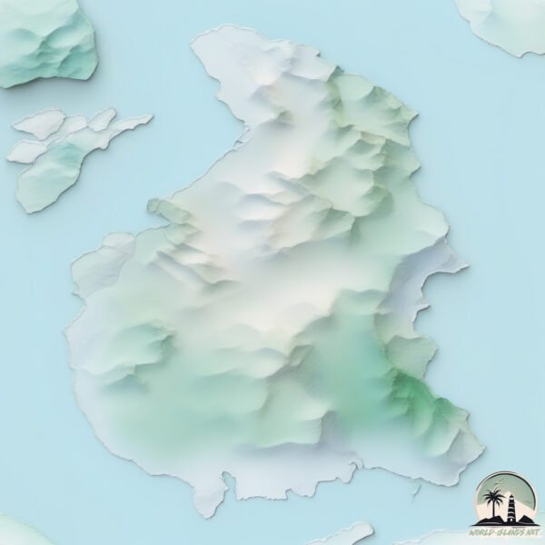
Geography and size of Gil
Size: 238.7 km²
Coastline: 126.6 km
Ocean: Pacific Ocean
Sea: The Coastal Waters of Southeast Alaska and British Columbia
Continent: North America
Gil is a Large Island spanning 239 km² with a coastline of 127 km.
Archipel: –
Tectonic Plate: Eurasia – One of the world’s largest tectonic plates, the Eurasian Plate covers a significant portion of Europe and Asia. It’s characterized by diverse geological features, including the Ural Mountains, the European Plain, and the Himalayas formed from its collision with the Indian Plate.
The geographic heart of the island is pinpointed at these coordinates:
Latitude: 53.19056904 / Longitude: -129.2431556
Climate and weather of Gil
Climate Zone: Temperate
Climate Details: Temperate Oceanic Climate
Temperature: Warm Summer
Climate Characteristics: Known for its moderate year-round temperatures with ample rainfall and no dry season. Warm summers are characteristic.
Topography and nature of Gil
Timezone: UTC-08:00
Timezone places: America/Los_Angeles
Max. Elevation: 719 m
Mean Elevation: 190 m
Vegetation: Evergreen Needleleaf Forest
Tree Coverage: 72%
The mean elevation is 190 m. The highest elevation on the island reaches approximately 719 meters above sea level. The island is characterized by Plateau: Elevated flatlands rising sharply above the surrounding area, with a maximum elevation over 500 meters but a mean elevation less than 300 meters, forming unique highland areas on islands.
Dominating Vegetation: Evergreen Needleleaf Forest
Dominated by evergreen coniferous trees such as pines and firs, which retain their needle-like leaves throughout the year. These forests are often found in cooler climates. Gil has a tree cover of 72 %.
Vegetation: 8 vegetation zones – Very Highly Diverse Island
Islands in this range are ecological powerhouses, showcasing a wide array of vegetation zones. Each zone, from lush rainforests to arid scrublands, coastal mangroves to mountainous regions, contributes to a complex and interdependent ecosystem. These islands are often hotspots of biodiversity, supporting numerous species and intricate ecological processes.
Infrastructure and Travelling to Gil
Does the island have a public airport? no.
There is no public and scheduled airport on Gil. The nearest airport is Northwest Regional Airport Terrace-Kitimat, located 147 km away.
Does the island have a major port? no.
There are no major ports on Gil. The closest major port is BUTEDALE, approximately 51 km away.
The mean population of Gil is 0 per km². Gil is Uninhabited. The island belongs to Canada.
Continuing your journey, Fin is the next notable island, situated merely km away.
GILI ISLANDS, Lombok - Ultimate TRAVEL GUIDE to ALL Beaches, Snorkeling, TURTLES in 4K

Canada is classified as Developed region: G7: Group of Seven – Major advanced economies, including Canada, France, Germany, Italy, Japan, the United Kingdom, and the United States. The level of income is High income: OECD.
News – Latest Updates and Headlines from Gil
Stay informed with the most recent news and important headlines from Gil. Here’s a roundup of the latest developments.
Please note: The data used here has been primarily extracted from satellite readings. Deviations from exact values may occur, particularly regarding the height of elevations and population density. Land area and coastline measurements refer to average values at mean high tide.