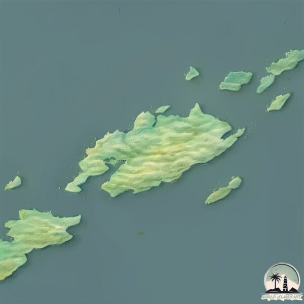
Welcome to Gilmour Island, a Polar island in the Hudson Bay, part of the majestic Arctic Ocean. This guide offers a comprehensive overview of what makes Gilmour Island unique – from its geography and climate to its population, infrastructure, and beyond. Dive into the details:
Geography and size of Gilmour Island
Size: 92.6 km²
Coastline: 88.9 km
Ocean: Arctic Ocean
Sea: Hudson Bay
Continent: North America
Gilmour Island is a Medium Island spanning 93 km² with a coastline of 89 km.
Archipel: –
Tectonic Plate: North America – Covers North America and parts of the Atlantic and Arctic Oceans, characterized by diverse geological features and varying levels of seismic activity.
The geographic heart of the island is pinpointed at these coordinates:
Latitude: 59.82067549 / Longitude: -80.04623258
Climate and weather of Gilmour Island
Climate Zone: Polar
Climate Details: Tundra
Temperature: Cold
Climate Characteristics: The tundra climate features long, extremely cold winters and short, cool summers. Vegetation is limited to mosses, lichens, and small shrubs due to the low temperatures and short growing seasons. Biodiversity is low, but some specialized species thrive.
Topography and nature of Gilmour Island
Timezone: UTC-05:00
Timezone places: America/New_York
Max. Elevation: 284 m
Mean Elevation: 120 m
Vegetation: Herbaceous Cover
Tree Coverage: 7%
The mean elevation is 120 m. The highest elevation on the island reaches approximately 284 meters above sea level. The island is characterized by Hills: Gently sloping landforms with rounded tops, having a maximum elevation between 200 and 500 meters. Hills contribute to a varied landscape on islands.
Dominating Vegetation: Herbaceous Cover
Comprising mainly of grasses, herbs, and ferns, these areas are common in prairies, meadows, and savannas, and can vary widely in species composition. Gilmour Island has a tree cover of 7 %.
Vegetation: 4 vegetation zones – Diverse Island
Four distinct vegetation zones mark these islands as ecologically diverse. They might feature varied landscapes such as forests, beaches, grasslands, and rocky areas. Such diversity reflects the island’s complex ecological interactions and varied habitats, which can support a rich array of wildlife and plant species.
Infrastructure and Travelling to Gilmour Island
Does the island have a public airport? no.
There is no public and scheduled airport on Gilmour Island. The nearest airport is Akulivik Airport, located 226 km away.
Does the island have a major port? no.
There are no major ports on Gilmour Island. The closest major port is HERON BAY, approximately 1411 km away.
The mean population of Gilmour Island is 0 per km². Gilmour Island is Uninhabited. The island belongs to Canada.
Continuing your journey, Pattee Island is the next notable island, situated merely km away.
David Gilmour - On An Island feat. Crosby & Nash (Remember That Night)
A performance of 'On An Island' feat. Crosby & Nash live from Remember That Night. Announcing 'Live at the Circus Maximus, ...David Gilmour - On An Island feat. Crosby & Nash (Remember That Night)
A performance of 'On An Island' feat. Crosby & Nash live from Remember ...
A performance of 'On An Island' feat. Crosby & Nash live from Remember That Night. Announcing 'Live at the Circus Maximus, ...
David Gilmour - On An Island (Live At Pompeii)
A performance of 'On An Island' live at Pompeii. Announcing 'Live at ...
A performance of 'On An Island' live at Pompeii. Announcing 'Live at the Circus Maximus, Rome' a live film in theatres September ...
David Gilmour On A Island
From David Gilmour's album "On An Island".
From David Gilmour's album "On An Island".
Island Jam
Provided to YouTube by Aviator-Management GmbH & Co. KG Island Jam · ...
Provided to YouTube by Aviator-Management GmbH & Co. KG Island Jam · David Gilmour Smile ℗ Parlophone UK Released on: ...
David Gilmour - On An Island (Live In Gdańsk)
A performance of 'On An Island' live in Gdańsk. Announcing 'Live at ...
A performance of 'On An Island' live in Gdańsk. Announcing 'Live at the Circus Maximus, Rome' a live film in theatres September ...
David Gilmour - On An Island (Official Music Video)
An official music video for 'On An Island'. Announcing 'Live at the ...
An official music video for 'On An Island'. Announcing 'Live at the Circus Maximus, Rome' a live film in theatres September 17.
David Gilmour - On An Island (Official Audio)
A Spinning Record Video of 'On An Island' (Official Audio) featured on ...
A Spinning Record Video of 'On An Island' (Official Audio) featured on the album 'On An Island'. Announcing 'Live at the Circus ...
On an Island David Gilmour Full Album 2006
David Gilmour - " Castellorizon " - On an Island
On an Island , Live In Gdansk 2006 "On An Island" Remember that night ...
On an Island , Live In Gdansk 2006 "On An Island" Remember that night White steps in the moonlight They walked here too ...
David Gilmour - On An Island (Von Trapped Series)
On An Island, performed by David on 23rd April 2020, as part of the ...
On An Island, performed by David on 23rd April 2020, as part of the Von Trapped Family livestream series, watch the full ...
David Gilmour - (Pink Floyd) - Island Jam
David Gilmour playing tracks from his new solo album On An Island PFFan.
David Gilmour playing tracks from his new solo album On An Island PFFan.
On An Island (Edit)
Provided to YouTube by Aviator-Management GmbH & Co. KG On An Island ...
Provided to YouTube by Aviator-Management GmbH & Co. KG On An Island (Edit) · David Gilmour On An Island (Edit) ...
David Gilmour - On An Island
Remember That Night DVD 2007.
Remember That Night DVD 2007.
David Gilmour - Island Jam
Heerlijke Blues jam.
Heerlijke Blues jam.
David Gilmour - On An Island (Official Lyrics Video)
A Official Lyric video of 'On An Island'. Announcing 'Live at the ...
A Official Lyric video of 'On An Island'. Announcing 'Live at the Circus Maximus, Rome' a live film in theatres September 17.
David Gilmour - On an Island - HD
David Gilmour Live in concert DVD available to buy at: ...
DAVID GILMOUR - On An Island - Remember That Night - Royal Albert Hall
Remember that night White steps in the moonlight They walked here too ...
Remember that night White steps in the moonlight They walked here too Through empty playground, this ghosts' town Children ...
David Gilmour - Live at the Royal Albert Hall 2006 Full Concert
Remember That Night, On an Island Tour live concert recording of Pink ...
Remember That Night, On an Island Tour live concert recording of Pink Floyd guitarist David Gilmour's solo concerts at the Royal ...
David Gilmour Island Jam HQ
David Gilmour Island Jam HQ.
David Gilmour Island Jam HQ.
David Gilmour - On An Island (Live In Gdansk Official Audio)
A Spinning Record Video of 'On An Island' (Live in Gdansk Official ...
A Spinning Record Video of 'On An Island' (Live in Gdansk Official Audio) featured on the album 'Live in Gdansk'. Announcing ...
David Gilmour - On An Island / Guitar Solo (1+2) Backing Track (w/ Vocals)
1. Solo: 0:00 / 2. Solo 2:01 / Download Backing Track in High Quality: ...
1. Solo: 0:00 / 2. Solo 2:01 / Download Backing Track in High Quality: ...
David Gilmour HD - Remember That Night (Full Concert, Royal Albert Hall 2006)
David Gilmour - On an island - Subtitulado
PINK FLOYD:DAVID GILMOUR ~Best Guitar Solo~『On An Island~Non stop MIX version~ 』
DAVID GILMOUR:Live At The Royal Albert Hall 2006 Guitars : DAVID ...
DAVID GILMOUR:Live At The Royal Albert Hall 2006 Guitars : DAVID GILMOUR Keyboard : RICHARD WRIGHT Keyboard : JON ...
David Gilmour - AOL Sessions - On an Island
David Gilmour and Rick Wright without Pink floyd in 2007 performing an ...
David Gilmour and Rick Wright without Pink floyd in 2007 performing an amazing show for AOL music.
Canada is classified as Developed region: G7: Group of Seven – Major advanced economies, including Canada, France, Germany, Italy, Japan, the United Kingdom, and the United States. The level of income is High income: OECD.
News – Latest Updates and Headlines from Gilmour Island
Stay informed with the most recent news and important headlines from Gilmour Island. Here’s a roundup of the latest developments.
Loading...
Please note: The data used here has been primarily extracted from satellite readings. Deviations from exact values may occur, particularly regarding the height of elevations and population density. Land area and coastline measurements refer to average values at mean high tide.