Huacas
Welcome to Huacas, a Dry island in the South Pacific Ocean, part of the majestic Pacific Ocean. This guide offers a comprehensive overview of what makes Huacas unique – from its geography and climate to its population, infrastructure, and beyond. Dive into the details:
- Geography and Size: Explore the island’s size and location.
- Climate and Weather: Weather patterns and temperature.
- Topography and Nature: Uncover the natural wonders of the island.
- Infrastructure and Travelling: Insights on reaching, staying, and making the most of your visit.
- News and Headlines: Latest News.
Geography and size of Huacas
Size: 15.8 km²
Coastline: 26 km
Ocean: Pacific Ocean
Sea: South Pacific Ocean
Continent: South America
Huacas is a Medium Island spanning 16 km² with a coastline of 26 km.
Archipel: –
Tectonic Plate: North Andes – Located in South America, covering Colombia, Ecuador, and part of Venezuela, it is known for its seismic activity due to interactions with the South American Plate.
The geographic heart of the island is pinpointed at these coordinates:
Latitude: -3.35230066 / Longitude: -80.14441065
Climate and weather of Huacas
Climate Zone: Dry
Climate Details: Hot Semi-Arid (Steppe) Climate
Temperature: Hot
Climate Characteristics: Features hot summers and mild to warm winters. Receives more rainfall than hot deserts but less than tropical savannas, leading to a somewhat more varied landscape.
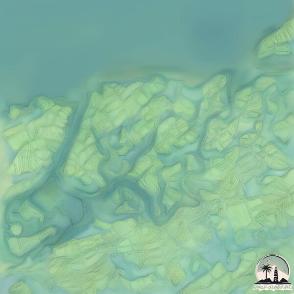
Topography and nature of Huacas
Timezone: UTC-05:00
Timezone places: America/New_York
Max. Elevation: 6 m
Mean Elevation: 4 m
Vegetation: Wetland
Tree Coverage: 100%
The mean elevation is 4 m. The highest elevation on the island reaches approximately 6 meters above sea level. The island is characterized by Plains: Flat, low-lying lands characterized by a maximum elevation of up to 200 meters. On islands, plains are typically coastal lowlands or central flat areas.
Dominating Vegetation: Wetland
These areas are saturated with water, either permanently or seasonally, and support aquatic plants. Wetlands are important for biodiversity and water filtration. Huacas has a tree cover of 100 %.
Vegetation: 6 vegetation zones – Very Highly Diverse Island
Islands in this range are ecological powerhouses, showcasing a wide array of vegetation zones. Each zone, from lush rainforests to arid scrublands, coastal mangroves to mountainous regions, contributes to a complex and interdependent ecosystem. These islands are often hotspots of biodiversity, supporting numerous species and intricate ecological processes.
Infrastructure and Travelling to Huacas
Does the island have a public airport? no.
There is no public and scheduled airport on Huacas. The nearest airport is Santa Rosa – Artillery Colonel Victor Larrea International Airport, located 16 km away.
Does the island have a major port? no.
There are no major ports on Huacas. The closest major port is PUERTO BOLIVAR, approximately 15 km away.
The mean population of Huacas is 9 per km². Huacas is Gently Populated. The island belongs to Ecuador.
Continuing your journey, Patria is the next notable island, situated merely km away.
The Stone Forest on Huayao Island evolved after volcanic eruptions, dating back 130 million years


Ecuador is classified as Developing region: Regions characterized by lower income levels, with economies in the process of industrialization and modernization. The level of income is Upper middle income.
News – Latest Updates and Headlines from Huacas
Stay informed with the most recent news and important headlines from Huacas. Here’s a roundup of the latest developments.
Please note: The data used here has been primarily extracted from satellite readings. Deviations from exact values may occur, particularly regarding the height of elevations and population density. Land area and coastline measurements refer to average values at mean high tide.