Welcome to Iguana, a Tropical island in the Caribbean Sea, part of the majestic Atlantic Ocean. This guide offers a comprehensive overview of what makes Iguana unique – from its geography and climate to its population, infrastructure, and beyond. Dive into the details:
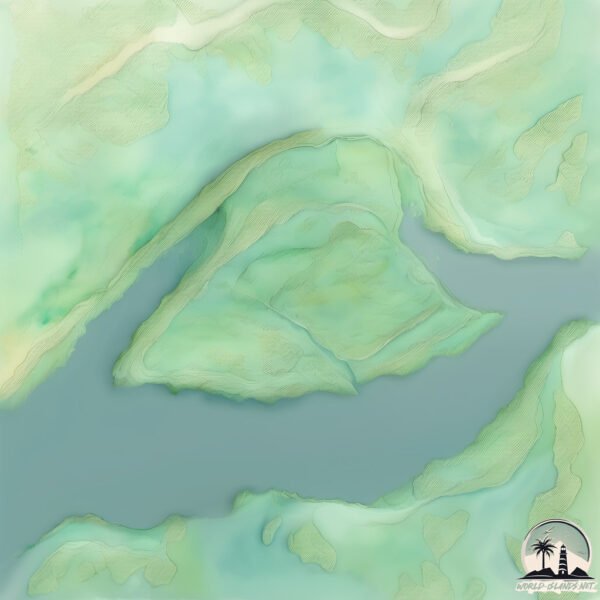
Geography and size of Iguana
Size: 12.5 km²
Coastline: 18.1 km
Ocean: Atlantic Ocean
Sea: Caribbean Sea
Continent: South America
Iguana is a Medium Island spanning 12 km² with a coastline of 18 km.
Archipel: –
Tectonic Plate: South America – A major plate covering the South American continent and part of the Atlantic Ocean, known for the Andes mountain range and significant seismic and volcanic activity.
The geographic heart of the island is pinpointed at these coordinates:
Latitude: 8.58582381 / Longitude: -62.29964125
Climate and weather of Iguana
Climate Zone: Tropical
Climate Details: Tropical Savanna, Wet
Temperature: Hot
Climate Characteristics: Defined by distinct wet and dry seasons with high temperatures year-round. Pronounced rainfall occurs during the wet season, while the dry season is marked by drought.
Topography and nature of Iguana
Timezone: UTC-04:30
Timezone places: America/Caracas
Max. Elevation: 13 m
Mean Elevation: 11 m
Vegetation: Wetland
Tree Coverage: 59%
The mean elevation is 11 m. The highest elevation on the island reaches approximately 13 meters above sea level. The island is characterized by Plains: Flat, low-lying lands characterized by a maximum elevation of up to 200 meters. On islands, plains are typically coastal lowlands or central flat areas.
Dominating Vegetation: Wetland
These areas are saturated with water, either permanently or seasonally, and support aquatic plants. Wetlands are important for biodiversity and water filtration. Iguana has a tree cover of 59 %.
Vegetation: 4 vegetation zones – Diverse Island
Four distinct vegetation zones mark these islands as ecologically diverse. They might feature varied landscapes such as forests, beaches, grasslands, and rocky areas. Such diversity reflects the island’s complex ecological interactions and varied habitats, which can support a rich array of wildlife and plant species.
Infrastructure and Travelling to Iguana
Does the island have a public airport? no.
There is no public and scheduled airport on Iguana. The nearest airport is General Manuel Carlos Piar International Airport, located 58 km away.
Does the island have a major port? no.
There are no major ports on Iguana. The closest major port is PALUA, approximately 46 km away.
The mean population of Iguana is 20 per km². Iguana is Gently Populated. The island belongs to Venezuela.
Continuing your journey, Mata-Mata is the next notable island, situated merely km away.
Rare Look at How Marine Iguanas Feed Underwater | 4K UHD | A Perfect Planet | BBC Earth
Being the only lizard that gets its food from the sea, this reptile can stay underwater for thirty minutes but must come back up for air ...Rare Look at How Marine Iguanas Feed Underwater | 4K UHD | A Perfect Planet | BBC Earth
Being the only lizard that gets its food from the sea, this reptile ...
Being the only lizard that gets its food from the sea, this reptile can stay underwater for thirty minutes but must come back up for air ...
Iguana chased by killer snakes | Planet Earth II: Islands - BBC
The Marine Iguana | A Perfect Planet | BBC Earth
This sea-diving lizard only has 30 minutes to search for food before ...
This sea-diving lizard only has 30 minutes to search for food before his muscles seize up. Subscribe:
http://bit.ly/BBCEarthSub ...
Iguana vs Snakes (Full Clip) | Planet Earth II | BBC Earth
In this iconic clip from Planet Earth II, a den of snakes feverishly ...
In this iconic clip from Planet Earth II, a den of snakes feverishly hunt a lone iguana hatchling. Subscribe:
http://bit.ly/BBCEarthSub ...
Swimming Marine Iguanas | Galapagos | BBC Earth
In order to survive, Iguanas have adapted to tackle the rough seas in ...
In order to survive, Iguanas have adapted to tackle the rough seas in this harsh but wildlife rich environment. Watch more high ...
SWIMMING PIGS, GIANT IGUANAS, & HUNGRY SHARKS | Explore pig island and iguana island, Exuma Bahamas!
Exuma, Bahamas and the surrounding Exumas Cays are filled with ...
Exuma, Bahamas and the surrounding Exumas Cays are filled with beautiful and unique sites! Visit pig island where you can ...
IGUANA PASTA CATCH AND COOK
IGUANA PASTA CATCH AND COOK Growing up in Boca Raton, FL I would see ...
IGUANA PASTA CATCH AND COOK Growing up in Boca Raton, FL I would see iguanas EVERYWHERE. To say they are ...
The Marine Iguana Is Like Something Time Forgot
The Galapagos islands off the Pacific coast of south America is a true ...
The Galapagos islands off the Pacific coast of south America is a true living Jurassic world. Animals here evolved from their ...
Wildlife Instincts: Survival Techniques - Iguana vs. Basilisk | Free Documentary Nature
Wildlife Instincts - Episode 2: Survival Techniques - Iguana vs ...
Wildlife Instincts - Episode 2: Survival Techniques - Iguana vs Basilisk | Free Documentary Nature Watch "Wildlife Instincts: The ...
Iguana vs Snakes | 4K UHD | Planet Earth II | BBC Earth
This behaviour has never been filmed before! Hatchling marine iguanas ...
This behaviour has never been filmed before! Hatchling marine iguanas are attacked by snakes hunting en masse. This clip was ...
Marine iguanas of the Galapagos islands - BBC wildlife
Want more natural history and wildlife videos? Visit the official BBC ...
Want more natural history and wildlife videos? Visit the official BBC Earth channel:
http://bit.ly/BBCEarthWW BBC Earth The BBC ...
Swimming to an iguana island in the Bahamas! #iguana #bahamas #travel #bucketlist #swimmingpigs
Highborne Cay and Iguana Island, Ep-201
Follow along with us as we travel the coastal waters of the eastern ...
Follow along with us as we travel the coastal waters of the eastern United States and Bahamas while simultaneously renovating a ...
Iguana Island Song | Joyful Toddler Nursery Rhyme | Kidsjourney
SONG DESCRIPTION The Iguana Island Song is a joyful toddler nursery ...
SONG DESCRIPTION The Iguana Island Song is a joyful toddler nursery rhyme that takes children on a fun tropical adventure ...
Blue Iguana Fights Extinction and Wins!
On this episode of On Location, Mark and the crew are in one of the ...
On this episode of On Location, Mark and the crew are in one of the most remote parts of Grand Cayman Island to meet a lizard ...
Marine Iguana 🦖 Tiny GODZILLA of the Sea!
Marine Iguana - Tiny GODZILLA of the Sea! | 1 Minute Animals Which ...
Marine Iguana - Tiny GODZILLA of the Sea! | 1 Minute Animals Which animal would you like to see next? Send your request here ...
Marine Iguanas: The Mini Dinosaurs Under Threat In The Galapagos Islands | Vanishing Dragons
The Galapagos Islands is home to many magical creatures that seem to ...
The Galapagos Islands is home to many magical creatures that seem to be from other worlds, including the Marine Iguana.
I Caught A Giant Iguana In A 50 Foot Tree!!!
Bahamas - Iguana Island | Sylwilicious
Let me take you to the Iguana Island / Bahamas. Do you see how the ...
Let me take you to the Iguana Island / Bahamas. Do you see how the iguanas are trying to eat my red-painted toenails? They think ...
Strong wind on Iguana 🦎 Island in Turks and Caicos 🇹🇨 #tropical #beautiful #caribbean #travel
CINEMATIC FLIGHT MODE #Drone #Beach #Ocean #Travel #Dronenature4k ...
CINEMATIC FLIGHT MODE #Drone #Beach #Ocean #Travel #Dronenature4k #Islands 🏝️ @DroneNature4K Follow me on ...
Iguana Island: A Trip to the Planet's Weirdest Paradise
Please watch: "Driving Through Epic Mountain Roads!" ...
Bahamas Swimming pigs and iguanas
This YouTube shorts video will give you a taste of a vacation in the ...
This YouTube shorts video will give you a taste of a vacation in the Bahamas. Introducing the swimming pigs, iguanas, and ...
How The Marine Iguanas Survive The Extreme Galapagos Islands | Vanishing Dragons | The Reptile Room
Dive into the mysterious world of marine iguanas in the Galapagos ...
Dive into the mysterious world of marine iguanas in the Galapagos Islands in this captivating episode of "Vanishing Dragons.
Iguana Island In Bahamas!🦎🏝️ #iguanalove #bahamas #iguana #beach #reptiles
Iguana Island and Conch Cooking Experience Provo with Island Routes
Iguana Island and Conch Cooking Experience Provo ...
Iguana Island and Conch Cooking Experience Provo ...
Venezuela is classified as Emerging region: G20: Group of Twenty – Major economies comprising both developed and emerging countries, representing the world’s largest economies. The level of income is Upper middle income.
News – Latest Updates and Headlines from Iguana
Stay informed with the most recent news and important headlines from Iguana. Here’s a roundup of the latest developments.
Loading...
Please note: The data used here has been primarily extracted from satellite readings. Deviations from exact values may occur, particularly regarding the height of elevations and population density. Land area and coastline measurements refer to average values at mean high tide.