Welcome to Ikerasak, a Polar island in the Baffin Bay, part of the majestic Arctic Ocean. This guide offers a comprehensive overview of what makes Ikerasak unique – from its geography and climate to its population, infrastructure, and beyond. Dive into the details:
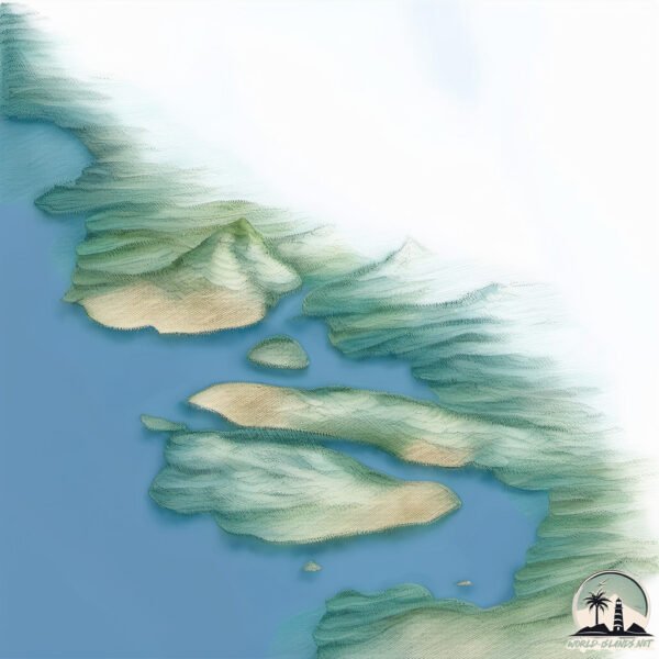
Geography and size of Ikerasak
Size: 46.8 km²
Coastline: 50.3 km
Ocean: Arctic Ocean
Sea: Baffin Bay
Continent: North America
Ikerasak is a Medium Island spanning 47 km² with a coastline of 50 km.
Archipel: –
Tectonic Plate: North America – Covers North America and parts of the Atlantic and Arctic Oceans, characterized by diverse geological features and varying levels of seismic activity.
The geographic heart of the island is pinpointed at these coordinates:
Latitude: 70.66508254 / Longitude: -51.75069997
Climate and weather of Ikerasak
Climate Zone: Polar
Climate Details: Tundra
Temperature: Cold
Climate Characteristics: The tundra climate features long, extremely cold winters and short, cool summers. Vegetation is limited to mosses, lichens, and small shrubs due to the low temperatures and short growing seasons. Biodiversity is low, but some specialized species thrive.
Topography and nature of Ikerasak
Timezone: UTC-03:00
Timezone places: America/Sao_Paulo
Max. Elevation: 644 m
Mean Elevation: 209 m
Vegetation: Herbaceous Cover
Tree Coverage: 23%
The mean elevation is 209 m. The highest elevation on the island reaches approximately 644 meters above sea level. The island is characterized by Plateau: Elevated flatlands rising sharply above the surrounding area, with a maximum elevation over 500 meters but a mean elevation less than 300 meters, forming unique highland areas on islands.
Dominating Vegetation: Herbaceous Cover
Comprising mainly of grasses, herbs, and ferns, these areas are common in prairies, meadows, and savannas, and can vary widely in species composition. Ikerasak has a tree cover of 23 %.
Vegetation: 4 vegetation zones – Diverse Island
Four distinct vegetation zones mark these islands as ecologically diverse. They might feature varied landscapes such as forests, beaches, grasslands, and rocky areas. Such diversity reflects the island’s complex ecological interactions and varied habitats, which can support a rich array of wildlife and plant species.
Infrastructure and Travelling to Ikerasak
Does the island have a public airport? yes.
Ikerasak has a public and scheduled airport. The following airports are located on this island: Ikerasak Heliport.
Does the island have a major port? no.
There are no major ports on Ikerasak. The closest major port is KAJALLEQ UPERNAVIK, approximately 52 km away.
The mean population of Ikerasak is 5 per km². Ikerasak is Gently Populated. The island belongs to Greenland.
Continuing your journey, Talerua is the next notable island, situated merely km away.
Grønland - Landgang i Ikerasak
Ikerasak i Grønland - det smukkeste sted i verden - 5. august 2010.Grønland - Landgang i Ikerasak
Ikerasak i Grønland - det smukkeste sted i verden - 5. august 2010.
Ikerasak i Grønland - det smukkeste sted i verden - 5. august 2010.
Best places to visit
Best places to visit - Ikerasak (Greenland) Best places to visit - ...
Best places to visit - Ikerasak (Greenland) Best places to visit - Slideshows from all over the world - City trips, nature pictures, etc.
🇬🇱 Greenland facts 🇩🇰 , Nuuk city, Aurora, geography facts
Some facts about the largest island that is not a continent on our ...
Some facts about the largest island that is not a continent on our globe. #island #greenland #denmark #arctic #nuuk #biggest ...
Kongernes jagtfalke på Grønland
Ekspedition til Grønland i forbindelse med bogen "Kongernes Jagtfalke" ...
Ekspedition til Grønland i forbindelse med bogen "Kongernes Jagtfalke" af Frank Wenzel, 2009. Undersøgelse og dokumentation ...
KALAALLIT NUNAAT in GREENLANDIC
Sermeq kujalleq (Ikerasak) glacier
NorthWest Greenland
The boat picked us up at Qaarsut and took us to one of the peninsulas ...
The boat picked us up at Qaarsut and took us to one of the peninsulas in the end of Uummannaq fjord, 600 km north of the Arctic ...
Wonders of Greenland | Most Beautiful Places in Greenland | 4K Travel Documentary
Wonders of Greenland | Most Beautiful Places in Greenland | 4K Travel ...
Wonders of Greenland | Most Beautiful Places in Greenland | 4K Travel Documentary Top 30 Wonders of Greenland: Nature, ...
Ikerasak - Kalaallit Nunaat
Ikerasak Koret fra Aalborg vandt 1. pladsen ved Tusariarlinngooq 2013 ...
Ikerasak Koret fra Aalborg vandt 1. pladsen ved Tusariarlinngooq 2013 som blev afholdt i Vejle d. 4. maj.
Ikerasak
Provided to YouTube by NAXOS of America Ikerasak · Gaman Early & Late ...
Provided to YouTube by NAXOS of America Ikerasak · Gaman Early & Late ℗ 2014 Dacapo SACD Released on: 2014-01-07 ...
Landing bell 212 in Uummannaq. greenland
Magisto.
Magisto.
Greenland, Uummannaq fjord with giant floes
Giant white floe in Qarajaq Isfjord in Baffin Bay in summer. High ...
Giant white floe in Qarajaq Isfjord in Baffin Bay in summer. High quality video. Uummannaq, amazing, arctic, atlantic, beautiful, ...
Grønlands Kommandoen 2012, Grønnedal
Turen til Grønland 2012 Stor tak til dem som gjorde denne tur mulig. ...
Turen til Grønland 2012 Stor tak til dem som gjorde denne tur mulig. Sammen med min svoger Lars blev dette en uforglemmelig ...
Grønland - Narsaq og helikopter!
12. september - 18. september 2017. I Narsaq på tjenesterejse. Der lå ...
12. september - 18. september 2017. I Narsaq på tjenesterejse. Der lå massere af isbjerge i bugten nær Narsaq. Jeg var med ...
Have you ever been to Uummannaq?
Have you ever been to Uummannaq? The town of Uummannaq in North ...
Have you ever been to Uummannaq? The town of Uummannaq in North Greenland is nicknamed the heart of Greenland.
Summer in Northwest Greenland
This is the last video of the journey in Uummannaq.
This is the last video of the journey in Uummannaq.
Greenland long
En längre berättelse från kajakresan till Grönland, Uummannaq, ...
En längre berättelse från kajakresan till Grönland, Uummannaq, sommaren 2016 med researrangören Trackers.
http://www.candray.se.
Uummannaq Tour around the Big island
Greenland, Uummannaq fjord close to the iceberg, danger floes around
Greenland, Uummannaq fjord close to the iceberg, danger floes around. ...
Greenland, Uummannaq fjord close to the iceberg, danger floes around. Qarajaq Isfjord in Baffin Bay in summer. High quality ...
Historien om koloniseringen til Vinland, Grønland & Island
Gribskov Gymnasium 1.u Historie Ismail, Emma, Martin & Amalie Kloge = ...
Gribskov Gymnasium 1.u Historie Ismail, Emma, Martin & Amalie Kloge = Martin.
Grønland - Ikerasaks hunde - 1/3
Ikerasaks slædehunde i sommer-lediggang, mens der ventes på is og ...
Ikerasaks slædehunde i sommer-lediggang, mens der ventes på is og slædeføre. Tage Christensen 5. august 2010.
West Greenland
west_greenland #nuuk_greenland Western Greenland is also known as Mid ...
west_greenland #nuuk_greenland Western Greenland is also known as Mid Greenland, and it spans from Nuuk in the south to a ...
Qaqqaliaq in Qeqertarsuaq Disko Greenland
Feltarbejde på Disko, Grønland
Ph.d.-studerende *Cecilie Skov Nielsen* fra Center for Permafrost ...
Ph.d.-studerende *Cecilie Skov Nielsen* fra Center for Permafrost (
http://cenperm.ku.dk) , Institut for Geovidenskab og ...
Uummannaq on a monday at noon
Parts of the town Uummannaq, Greenland.
Parts of the town Uummannaq, Greenland.
Greenland is classified as Developed region: nonG7: Developed economies outside of the Group of Seven, characterized by high income and advanced economic structures. The level of income is High income: OECD.
News – Latest Updates and Headlines from Ikerasak
Stay informed with the most recent news and important headlines from Ikerasak. Here’s a roundup of the latest developments.
Loading...
Please note: The data used here has been primarily extracted from satellite readings. Deviations from exact values may occur, particularly regarding the height of elevations and population density. Land area and coastline measurements refer to average values at mean high tide.