Imjado
Welcome to Imjado, a Temperate island in the Yellow Sea, part of the majestic Pacific Ocean. This guide offers a comprehensive overview of what makes Imjado unique – from its geography and climate to its population, infrastructure, and beyond. Dive into the details:
- Geography and Size: Explore the island’s size and location.
- Climate and Weather: Weather patterns and temperature.
- Topography and Nature: Uncover the natural wonders of the island.
- Infrastructure and Travelling: Insights on reaching, staying, and making the most of your visit.
- News and Headlines: Latest News.
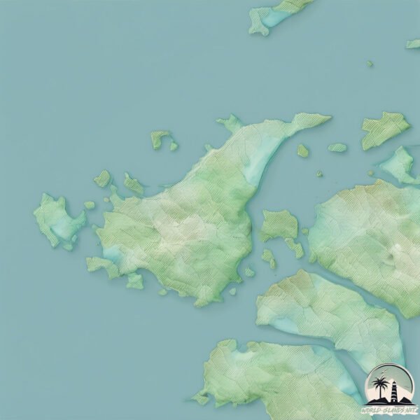
Geography and size of Imjado
Size: 50.4 km²
Coastline: 50.7 km
Ocean: Pacific Ocean
Sea: Yellow Sea
Continent: Asia
Imjado is a Medium Island spanning 50 km² with a coastline of 51 km.
Archipel: –
Tectonic Plate: Amur – A minor tectonic plate in the region of the Amur River at the border of Russia and China, involved in complex interactions with the Pacific and Eurasian plates.
The geographic heart of the island is pinpointed at these coordinates:
Latitude: 35.09323196 / Longitude: 126.09457216
Climate and weather of Imjado
Climate Zone: Temperate
Climate Details: Humid Subtropical Climate
Temperature: Hot Summer
Climate Characteristics: With continuous rainfall and hot summers, this climate is common in some coastal regions, supporting diverse vegetation.
Topography and nature of Imjado
Timezone: UTC+09:00
Timezone places: Asia/Tokyo
Max. Elevation: 142 m
Mean Elevation: 23 m
Vegetation: Agricultural Mosaic
Tree Coverage: 68%
The mean elevation is 23 m. The highest elevation on the island reaches approximately 142 meters above sea level. The island is characterized by Plains: Flat, low-lying lands characterized by a maximum elevation of up to 200 meters. On islands, plains are typically coastal lowlands or central flat areas.
Dominating Vegetation: Agricultural Mosaic
A mix of cropland and natural vegetation, often seen in rural landscapes where agricultural fields are interspersed with patches of natural habitats. Imjado has a tree cover of 68 %.
Vegetation: 12 vegetation zones – Exceptionally Diverse Island
Islands with more than ten vegetation zones are among the most ecologically rich and varied in the world. These islands are akin to miniature continents, boasting an incredible array of ecosystems. The sheer range of habitats, from high peaks to deep valleys, rainforests to deserts, creates a mosaic of life that is unparalleled. They are crucial for conservation and ecological studies.
Infrastructure and Travelling to Imjado
Does the island have a public airport? no.
There is no public and scheduled airport on Imjado. The nearest airport is Muan International Airport, located 30 km away.
Does the island have a major port? no.
There are no major ports on Imjado. The closest major port is MOKPO, approximately 43 km away.
The mean population of Imjado is 36 per km². Imjado is Gently Populated. The island belongs to South Korea.
Continuing your journey, Saokdo is the next notable island, situated merely km away.
TRAVEL IN KOREA ~ RURAL TRAVEL: IMJADO ISLAND

![병어와 민어의 고장, 신안 임자도 [Korea Island]](https://i.ytimg.com/vi/ZHVrFILd3OU/mqdefault.jpg)
South Korea is classified as Emerging region: MIKT: Mexico, Indonesia, South Korea, and Turkey – Economies recognized for their development potential and emerging market status. The level of income is High income: OECD.
News – Latest Updates and Headlines from Imjado
Stay informed with the most recent news and important headlines from Imjado. Here’s a roundup of the latest developments.
Please note: The data used here has been primarily extracted from satellite readings. Deviations from exact values may occur, particularly regarding the height of elevations and population density. Land area and coastline measurements refer to average values at mean high tide.