Welcome to Ios, a Temperate island in the Aegean Sea, part of the majestic Atlantic Ocean. This guide offers a comprehensive overview of what makes Ios unique – from its geography and climate to its population, infrastructure, and beyond. Dive into the details:
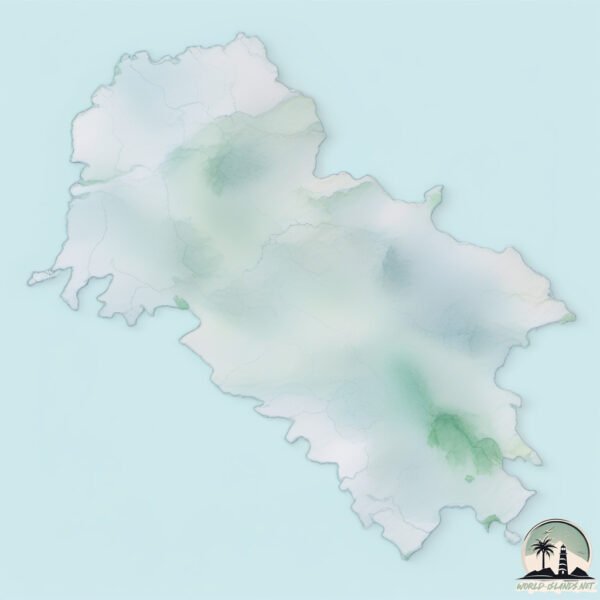
Geography and size of Ios
Size: 110.1 km²
Coastline: 80.7 km
Ocean: Atlantic Ocean
Sea: Aegean Sea
Continent: Europe
Ios is a Large Island spanning 110 km² with a coastline of 81 km.
Archipel: Cyclades – A group of islands in the Aegean Sea, part of Greece, known for their iconic white-washed architecture, beautiful beaches, and rich history.
Tectonic Plate: Eurasia – One of the world’s largest tectonic plates, the Eurasian Plate covers a significant portion of Europe and Asia. It’s characterized by diverse geological features, including the Ural Mountains, the European Plain, and the Himalayas formed from its collision with the Indian Plate.
The geographic heart of the island is pinpointed at these coordinates:
Latitude: 36.72141244 / Longitude: 25.32671733
Climate and weather of Ios
Climate Zone: Temperate
Climate Details: Hot-Summer Mediterranean Climate
Temperature: Hot Summer
Climate Characteristics: Characterized by hot, dry summers and mild, wet winters, typical of coastal areas with abundant sunshine.
Topography and nature of Ios
Timezone: UTC+02:00
Timezone places: Europe/Mariehamn
Max. Elevation: 660 m
Mean Elevation: 181 m
Vegetation: Agricultural Mosaic
Tree Coverage: 17%
The mean elevation is 181 m. The highest elevation on the island reaches approximately 660 meters above sea level. The island is characterized by Plateau: Elevated flatlands rising sharply above the surrounding area, with a maximum elevation over 500 meters but a mean elevation less than 300 meters, forming unique highland areas on islands.
Dominating Vegetation: Agricultural Mosaic
A mix of cropland and natural vegetation, often seen in rural landscapes where agricultural fields are interspersed with patches of natural habitats. Ios has a tree cover of 17 %.
Vegetation: 11 vegetation zones – Exceptionally Diverse Island
Islands with more than ten vegetation zones are among the most ecologically rich and varied in the world. These islands are akin to miniature continents, boasting an incredible array of ecosystems. The sheer range of habitats, from high peaks to deep valleys, rainforests to deserts, creates a mosaic of life that is unparalleled. They are crucial for conservation and ecological studies.
Infrastructure and Travelling to Ios
Does the island have a public airport? no.
There is no public and scheduled airport on Ios. The nearest airport is Santorini Airport, located 30 km away.
Does the island have a major port? no.
There are no major ports on Ios. The closest major port is NISOS NAXOS, approximately 35 km away.
The mean population of Ios is 18 per km². Ios is Gently Populated. The island belongs to Greece.
Continuing your journey, Nisí Irákleia is the next notable island, situated merely km away.
THE DREAM GREEK ISLAND FOR 2026! 🇬🇷 IOS (CYCLADES)
Check out Discover Cars for great budget car rental deals in Greece and around the world here: ...THE DREAM GREEK ISLAND FOR 2026! 🇬🇷 IOS (CYCLADES)
Check out Discover Cars for great budget car rental deals in Greece ...
Check out Discover Cars for great budget car rental deals in Greece and around the world here: ...
Discover Ios Greece - Full Island Guide 2025/26
If you're planning your Greek Island adventure DON'T MISS OUT on the ...
If you're planning your Greek Island adventure DON'T MISS OUT on the best islands in the Cyclades - Ios! This guide has ...
Discover Ios GREECE - Full Island Guide 2025 🇬🇷
Ios is one of our favourite Greek islands, effortlessly combining a ...
Ios is one of our favourite Greek islands, effortlessly combining a vibrant nightlife scene with stunning beaches, while retaining an ...
Ios Greece Travel Guide: HIDDEN GEM Near Santorini You’ll Wish You Discovered SOONER | Greek Islands
Ios Greece Travel Guide: Hidden Gem Near Santorini You'll Wish You ...
Ios Greece Travel Guide: Hidden Gem Near Santorini You'll Wish You Discovered Sooner - this is your complete Ios Greece travel ...
iPhone 18 Pro's Smaller Dynamic Island Leaks?! iOS 26.5 & Apple's 50th Anniversary!
Use Code 'BRIANTFP' to save an extra 30% OFF on Dreame's Limited ...
5 Ways to ACTUALLY Use the Dynamic Island
Don't know what to make of Dynamic Island? Nor did I until I came ...
Don't know what to make of Dynamic Island? Nor did I until I came across these 5 neat apps that utilise lonely Island!
IOS - Greece - Must-Visit Budget Friendly Travel Destinations for 2023 🍕🍺😍 ☀️🏄✈️❤️🌅
Must-Visit Budget Friendly Travel Destinations for 2023 - IOS - Greece ...
Must-Visit Budget Friendly Travel Destinations for 2023 - IOS - Greece ☀️ ✈️❤️ | Beach, Party, Food, Relax ...
Ios Island Greece | Paradise on Earth
Join us as we explore the stunning island of Ios, Greece, often ...
Join us as we explore the stunning island of Ios, Greece, often referred to as Paradise on Earth. Known for its vibrant party scene, ...
The cost to switch islands in Greece | Santorini Ios
IOS is MORE than just a party island! (better than MYKONOS?)
Ios, Greece Travel Vlog. In this Ios travel guide, I show you how to ...
Ios, Greece Travel Vlog. In this Ios travel guide, I show you how to travel Ios, best place to stay in Ios, what to do & best beach.
Avoid the crowds in this beautiful Greek island! #ios #greece
I can't believe everyone travels to Santorini, but they skip this ...
I can't believe everyone travels to Santorini, but they skip this beautiful Greek island only 30 minutes away by ferry! SUBSCRIBE!
iPhone 17 Dynamic Island Secrets 👀 (You NEED to Try This!)
Watch my full Dynamic Island tutorial here: ...
Top 10 Things To Do in Ios Greece 2022
Hey Fellow Travellers in this video we are going to talk about the Top ...
Hey Fellow Travellers in this video we are going to talk about the Top 10 things to Do in Ios Greece. ✈Travel Hack To book ...
Ios Greece Travel Guide: 11 BEST Things To Do In Ios
How to find cheap flights and travel more: ...
Ios Island Travel Guide: Exploring the Best Greek Places
Ios Island is one of the most breathtaking destinations in Greece, ...
Ios Island is one of the most breathtaking destinations in Greece, offering an unparalleled blend of natural beauty, vibrant culture, ...
Add Dynamic Island on Any Iphone using Wallspace iOS
iOS Appstore.
iOS Appstore.
Ios Island Virtual Tour
This is a walking tour from the up and coming Greek island of Ios. In ...
This is a walking tour from the up and coming Greek island of Ios. In the video I walk from Ios Port to Koumpara and explore the ...
One Day in IOS, GREECE 🇬🇷 This Island's Beauty is UNREAL!
Here we spend 24 hours in Ios, Greece! We explore as much of this ...
Here we spend 24 hours in Ios, Greece! We explore as much of this Greek Island including the port, Chora, and Paralia Milopotas ...
The Calilo Resort on Ios Island , Greece 🇬🇷
iPhone Dynamic Island vs Xiaomi Hyper Island — the animation battle begins! 🍿
Everything we ate in Ios Island, Greece!
💥 Dynamic Island on iPhone 14 Pro - Hands On
Here's a quick hands on of Dynacmic Island on iPhone 14 Pro. #shorts ...
Exploring the Greek Island of Ios | Ios, Greece Travel Vlog
Exploring the Greek Island of Ios! In this Ios, Greece Travel Vlog I ...
Exploring the Greek Island of Ios! In this Ios, Greece Travel Vlog I bring you along for all the adventures in Ios. Recently my friend ...
IOS | The Other Side of the Greek Party Island
A day of exploring the beautiful island of Ios in the Aegean Sea of ...
A day of exploring the beautiful island of Ios in the Aegean Sea of Greece, beyond the main beaches and the young party scene.
Ios (Greece) - Why the Cyclades Party Island is More Than Just Nightlife (4K)
Ios, Greece – Beyond the Parties: Secluded Beaches, Homer's Tomb & ...
Ios, Greece – Beyond the Parties: Secluded Beaches, Homer's Tomb & Golden Sunsets ☀️ While famous for its nightlife, we ...
Greece is classified as Developed region: nonG7: Developed economies outside of the Group of Seven, characterized by high income and advanced economic structures. The level of income is High income: OECD.
News – Latest Updates and Headlines from Ios
Stay informed with the most recent news and important headlines from Ios. Here’s a roundup of the latest developments.
Loading...
Please note: The data used here has been primarily extracted from satellite readings. Deviations from exact values may occur, particularly regarding the height of elevations and population density. Land area and coastline measurements refer to average values at mean high tide.