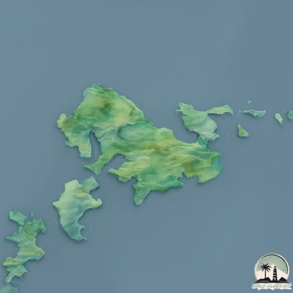
Welcome to Kamikoshiki Jima, a Temperate island in the Eastern China Sea, part of the majestic Pacific Ocean. This guide offers a comprehensive overview of what makes Kamikoshiki Jima unique – from its geography and climate to its population, infrastructure, and beyond. Dive into the details:
Geography and size of Kamikoshiki Jima
Size: 44.5 km²
Coastline: 73.1 km
Ocean: Pacific Ocean
Sea: Eastern China Sea
Continent: Asia
Kamikoshiki Jima is a Medium Island spanning 44 km² with a coastline of 73 km.
Archipel: Japan – An East Asian archipelago comprising four main islands and numerous smaller ones, known for its rich history, technological advances, and distinct culture.
Tectonic Plate: Eurasia – One of the world’s largest tectonic plates, the Eurasian Plate covers a significant portion of Europe and Asia. It’s characterized by diverse geological features, including the Ural Mountains, the European Plain, and the Himalayas formed from its collision with the Indian Plate.
The geographic heart of the island is pinpointed at these coordinates:
Latitude: 31.84532809 / Longitude: 129.87689935
Climate and weather of Kamikoshiki Jima
Climate Zone: Temperate
Climate Details: Humid Subtropical Climate
Temperature: Hot Summer
Climate Characteristics: With continuous rainfall and hot summers, this climate is common in some coastal regions, supporting diverse vegetation.
Topography and nature of Kamikoshiki Jima
Timezone: UTC+09:00
Timezone places: Asia/Tokyo
Max. Elevation: 273 m
Mean Elevation: 96 m
Vegetation: Evergreen Broadleaf Forest
Tree Coverage: 95%
The mean elevation is 96 m. The highest elevation on the island reaches approximately 273 meters above sea level. The island is characterized by Hills: Gently sloping landforms with rounded tops, having a maximum elevation between 200 and 500 meters. Hills contribute to a varied landscape on islands.
Dominating Vegetation: Evergreen Broadleaf Forest
Characterized by dense, lush canopies of broadleaf trees that retain their leaves year-round. These forests are typically found in tropical and subtropical regions and are known for their high biodiversity. Kamikoshiki Jima has a tree cover of 95 %.
Vegetation: 5 vegetation zones – Highly Diverse Island
With five different vegetation zones, these islands offer a rich tapestry of ecosystems. The variety could include dense forests, open meadows, wetlands, coastal zones, and more. This level of diversity supports an intricate web of life, with each zone playing a vital role in the overall ecological health and balance of the island.
Infrastructure and Travelling to Kamikoshiki Jima
Does the island have a public airport? no.
There is no public and scheduled airport on Kamikoshiki Jima. The nearest airport is Amakusa Airport, located 72 km away.
Does the island have a major port? no.
There are no major ports on Kamikoshiki Jima. The closest major port is MINAMATA KO, approximately 62 km away.
The mean population of Kamikoshiki Jima is 139 per km². Kamikoshiki Jima is Moderately Inhabited. The island belongs to Japan.
Continuing your journey, Shimokoshiki Jima is the next notable island, situated merely km away.
1 day trip to koshiki island
walk around in Nagahama, shimokoshiki Koshiki island, Kagoshima Trekking "kashinoki kodo" old school road Lunch at ...1 day trip to koshiki island
walk around in Nagahama, shimokoshiki Koshiki island, Kagoshima ...
walk around in Nagahama, shimokoshiki Koshiki island, Kagoshima Trekking "kashinoki kodo" old school road Lunch at ...
【🇯🇵Koshikijima Islands|Kagoshima |】Trip to a remote island|Satsumasendai
Kagoshima Travel (3)/Koshikishima / from kamikoshikishima to Teuchi ...
Kagoshima Travel (3)/Koshikishima / from kamikoshikishima to Teuchi Beach in Shimokoshikishima ⭐️ Satsumasendai City, ...
07/05/2025 Day 2 - Hidden Paradise off Kamikoshiki
We left Kamikoshiki Island early in the morning and headed toward ...
We left Kamikoshiki Island early in the morning and headed toward Fukue Island. Before crossing open waters, we made two ...
No. 217 Koshiki Islands/ Travels of Scenic Japan / Tabiator
Western islands of Kagoshima Prefecture with three manned islands in ...
Western islands of Kagoshima Prefecture with three manned islands in Kagoshima Prefecture #Japan #scenic #travel ...
Kamikoshiki walking
Kamikoshiki Island.
Kamikoshiki Island.
【🇯🇵Koshikijima Islands】Ferry New Koshiki|Trip to a remote island|Satsumasendai, Kagoshima
Kagoshima Prefecture Trip② From Kushikino New Port to Satominato ◎Car: ...
Kagoshima Prefecture Trip② From Kushikino New Port to Satominato ◎Car: Ferry New Koshiki. Reservations required.
甑島への旅 A trip to Koshiki Jima
We only managed to take a three day vacation this year. Some corners ...
We only managed to take a three day vacation this year. Some corners within the family considered this an extravagant ...
Shimo-Koshikijima Highlights
Koshikijima is off the coast of Kagoshima. It's a rugged and isolated ...
Koshikijima is off the coast of Kagoshima. It's a rugged and isolated place that sees very few visitors. We explored ...
【🇯🇵Koshikijima Islands|Kagoshima |】Driving Around Koshikishima Islands |Satsumasendai
Kagoshima Trip 4/Koshikishima /Koshikishima Round Trip Drive ...
Kagoshima Trip 4/Koshikishima /Koshikishima Round Trip Drive ◎Shimokoshikishima, Nagahama Port→Aosehama→Seo ...
East China Sea, 82 km Southwest of Kamikoshiki Jima Island, Kagoshima-ken, Japan Earthquake today
Earthquakes : Earthquake today now news update #earthquake : A light ...
Earthquakes : Earthquake today now news update #earthquake : A light magnitude 2.9 earthquake occurred, in the East China ...
KOSHIKI ISLAND VLOG
今年も行ってきました 何があってもここには帰ってくるって決めてたので今年は1泊2日で、、、 流れ星いっぱいみれたのが ...
今年も行ってきました 何があってもここには帰ってくるって決めてたので今年は1泊2日で、、、 流れ星いっぱいみれたのが ...
JUDY KOSHIKI IN KOSHIKI ISLANDS movie by JKP
行ってきました、国立指定公園の あの甑島へ( `ー´)ノ とりあえず、ちらっとどうぞ(^^
行ってきました、国立指定公園の あの甑島へ( `ー´)ノ とりあえず、ちらっとどうぞ(^^
上甑島(かみこしきしま)の楽しみ方 沸騰ワード How to enjoy Koshiki Island 4k Drone DroneRanger Vlog #19
Koshiki Island in Kagoshima Japan So Nice Ocean and Beautiful Beach ...
Koshiki Island in Kagoshima Japan So Nice Ocean and Beautiful Beach 鹿児島県の甑島(こしきしま)に行ってきました!
絶景を誇る穴場の離島 下甑島
鹿児島の西の海に浮かぶ甑島列島は有人島である上甑島、中甑島、下甑島と多くの無人島からなる列島である。 「甑(こしき)」 ...
鹿児島の西の海に浮かぶ甑島列島は有人島である上甑島、中甑島、下甑島と多くの無人島からなる列島である。 「甑(こしき)」 ...
甑島プロモーション動画(R5) Koshikishima Promotional Video
Best Attractions and Places to See in Satsumasendai, Japan
Satsumasendai Travel Guide. MUST WATCH. Top things you have to do in ...
Satsumasendai Travel Guide. MUST WATCH. Top things you have to do in Satsumasendai. We have sorted Tourist Attractions in ...
Koshiki-Shima Islands Scenic Drive 4K | Sato Port to Teuchi, Kagoshima, Japan
Koshiki-shima Islands are a chain of islands off the coast of ...
Koshiki-shima Islands are a chain of islands off the coast of Kagoshima, with breathtaking sea cliffs and beautiful beaches.
Kamikoshikijima- 上甑島 Cảnh đẹp nên thơ.
Những bức ảnh trong chuyến thăm thực tập sinh tại đảo kamikoshiki. ...
Những bức ảnh trong chuyến thăm thực tập sinh tại đảo kamikoshiki. Cảnh đẹp tới xiêu lòng.
【甑島】Koshikijima 離島ツーリング
鹿児島県/Kagoshima 甑島列島/KOSHIKIJIMA フェリーで上甑島から下甑島まで走った時のツーリング動画です(^^) #vtwin ...
鹿児島県/Kagoshima 甑島列島/KOSHIKIJIMA フェリーで上甑島から下甑島まで走った時のツーリング動画です(^^) #vtwin ...
KANMURIDAKE JINJA Deep in Mountain (Satsumasendai City, Kagoshima, Japan)
Deep in mountain, we found the old shrine "KANMURIDAKE SHRINE" at ...
Deep in mountain, we found the old shrine "KANMURIDAKE SHRINE" at Satsumasendai City, Kagoshima Prefecture, Japan ...
下甑町瀬々野浦地区の全景 #shorts
下甑町瀬々野浦(しもこしきちょう せせのうら)は本当に美しい集落です。 □撮影機材 ・iPhone 13 Pro Max ...
下甑町瀬々野浦(しもこしきちょう せせのうら)は本当に美しい集落です。 □撮影機材 ・iPhone 13 Pro Max ...
360japan 甑島
鹿児島 甑島 kagoshima koshikijima.
鹿児島 甑島 kagoshima koshikijima.
【絶景】甑島(こしきしま)【ドローン空撮】と びーぐ Japan,Kagoshima,Koshiki Island [Drone aerial movie]
鹿児島県薩摩川内市 甑島(こしきしま)へ初上陸。鹿児島県薩摩半島から西へ約30キロ、薩摩川内市より船で約1時間。東シナ海に ...
鹿児島県薩摩川内市 甑島(こしきしま)へ初上陸。鹿児島県薩摩半島から西へ約30キロ、薩摩川内市より船で約1時間。東シナ海に ...
バイクで巡る日本の絶景、秘境 上甑島(かみこしきじま) 鹿児島県 #バイクツーリング #旅行 #モンキーbaja #絶景
甑島⎜KOSHIKI ISLAND
甑島すごく素敵なところなので、みんなにちょっとでもみせたいです♡ おすすめスポットです! シェアとかしてくれたら嬉しい ...
甑島すごく素敵なところなので、みんなにちょっとでもみせたいです♡ おすすめスポットです! シェアとかしてくれたら嬉しい ...
Japan is classified as Developed region: G7: Group of Seven – Major advanced economies, including Canada, France, Germany, Italy, Japan, the United Kingdom, and the United States. The level of income is High income: OECD.
News – Latest Updates and Headlines from Kamikoshiki Jima
Stay informed with the most recent news and important headlines from Kamikoshiki Jima. Here’s a roundup of the latest developments.
Loading...
Please note: The data used here has been primarily extracted from satellite readings. Deviations from exact values may occur, particularly regarding the height of elevations and population density. Land area and coastline measurements refer to average values at mean high tide.


![【絶景】甑島(こしきしま)【ドローン空撮】と びーぐ Japan,Kagoshima,Koshiki Island [Drone aerial movie]](https://i.ytimg.com/vi/HYYBA7eOZyA/mqdefault.jpg)

