Welcome to Karakelong, a Tropical island in the Philippine Sea, part of the majestic Pacific Ocean. This guide offers a comprehensive overview of what makes Karakelong unique – from its geography and climate to its population, infrastructure, and beyond. Dive into the details:
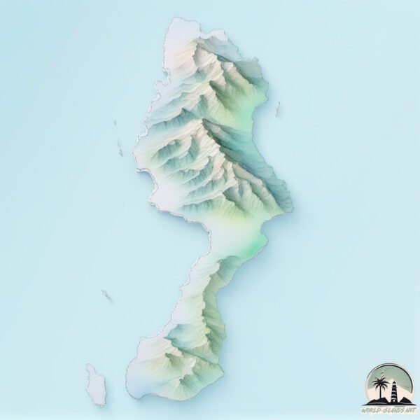
Geography and size of Karakelong
Size: 809.6 km²
Coastline: 217.6 km
Ocean: Pacific Ocean
Sea: Philippine Sea
Continent: Asia
Karakelong is a Large Island spanning 810 km² with a coastline of 218 km.
Archipel: Malay Archipelago – The world’s largest archipelago, located between mainland Southeast Asia and Australia, known for its immense biodiversity and cultural diversity.
Tectonic Plate: Sunda – Extends across Southeast Asia, encompassing parts of the Sunda Shelf, known for its interaction with the Australian Plate, contributing to volcanic activity in Indonesia.
The geographic heart of the island is pinpointed at these coordinates:
Latitude: 4.28793381 / Longitude: 126.78063955
Climate and weather of Karakelong
Climate Zone: Tropical
Climate Details: Tropical Rainforest Climate
Temperature: Hot
Climate Characteristics: This climate is typified by heavy rainfall throughout the year, high humidity, and consistently high temperatures, leading to lush rainforests and rich biodiversity. Seasonal temperature variations are minimal.
Topography and nature of Karakelong
Timezone: UTC+08:00
Timezone places: Australia/Perth
Max. Elevation: 533 m
Mean Elevation: 123 m
Vegetation: Evergreen Broadleaf Forest
Tree Coverage: 70%
The mean elevation is 123 m. The highest elevation on the island reaches approximately 533 meters above sea level. The island is characterized by Plateau: Elevated flatlands rising sharply above the surrounding area, with a maximum elevation over 500 meters but a mean elevation less than 300 meters, forming unique highland areas on islands.
Dominating Vegetation: Evergreen Broadleaf Forest
Characterized by dense, lush canopies of broadleaf trees that retain their leaves year-round. These forests are typically found in tropical and subtropical regions and are known for their high biodiversity. Karakelong has a tree cover of 70 %.
Vegetation: 12 vegetation zones – Exceptionally Diverse Island
Islands with more than ten vegetation zones are among the most ecologically rich and varied in the world. These islands are akin to miniature continents, boasting an incredible array of ecosystems. The sheer range of habitats, from high peaks to deep valleys, rainforests to deserts, creates a mosaic of life that is unparalleled. They are crucial for conservation and ecological studies.
Infrastructure and Travelling to Karakelong
Does the island have a public airport? no.
There is no public and scheduled airport on Karakelong. The nearest airport is Naha Airport, located 132 km away.
Does the island have a major port? no.
There are no major ports on Karakelong. The closest major port is TELUK BEO, approximately 1 km away.
The mean population of Karakelong is 127 per km². Karakelong is Moderately Inhabited. The island belongs to Indonesia.
Continuing your journey, Pulau Salebabu is the next notable island, situated merely km away.
Road trip karakelong island
indonesia #sulawesiutara #talaud #manado #fyp.Road trip karakelong island
indonesia #sulawesiutara #talaud #manado #fyp.
indonesia #sulawesiutara #talaud #manado #fyp.
Reading Karakelang Island in Talaud Regency, North Sulawesi Province. (Assignment From Mrs. Rulik)
Miangas (The Forgotten Island Between the Philippines and Indonesia): Lost Philippine Territory?
Who Owns Miangas? The Forgotten Island Between the Philippines and ...
Who Owns Miangas? The Forgotten Island Between the Philippines and Indonesia. Miangas Island, a small yet strategically ...
Discovering the Unseen: Nature's Unimaginable Island-Ception Secrets
Join us as we explore the mind-boggling island-ception phenomenon in ...
Join us as we explore the mind-boggling island-ception phenomenon in the Philippines, where Vulcan Point Island rests within a ...
WISATA KELILING 19 DESA DI PULAU KARAKELANG KABUPATEN TALAUD |SPECIAL HUT RI
WISATA KELILING 19 DESA DI PULAU KARAKELANG KABUPATEN TALAUD |SPECIAL ...
WISATA KELILING 19 DESA DI PULAU KARAKELANG KABUPATEN TALAUD |SPECIAL HUT RI Hello Guys Jadi ini video ...
Visiting the Closest Island to Indonesia
Just a few kilometers from this island is the boundary of the two ...
Just a few kilometers from this island is the boundary of the two countries, which are strictly guarded against those crossing ...
5.2 Earthquake Strikes Karakelong Island, Indonesia
KarakelongIsland #Indonesia #Earthquake on September 18th, 2025. Don't ...
KarakelongIsland #Indonesia #Earthquake on September 18th, 2025. Don't forget to subscribe & ring the bell for future updates, ...
Keliling Pulau terluar Indonesia, Pulau Karakelong deket philipina
Pulau Karakelong pulau terluar utara Indonesia berbatasan langsung ...
Pulau Karakelong pulau terluar utara Indonesia berbatasan langsung philipina. Menyimpan banyak misteri, lautnya juga very ...
KARAKELANG ISLAND
TALAUD.
TALAUD.
The Remote Island With A Statue That Nobody Can Explain
This is a bit of a continuation of our first video from this season, ...
This is a bit of a continuation of our first video from this season, but the story was so uniquely its own that I decided to split it off into ......[+] Show More Karakelang island - North Celebes - Indonesia
Keliling Pulau Karakelang Talaud 2024
Menyusuri Pulau Karakelong Dari Melonguane Sampai Ke Essang
Sebuah pengalaman yang mengagumkan bisa menginjakkan kaki di wilayah ...
Sebuah pengalaman yang mengagumkan bisa menginjakkan kaki di wilayah paling utara Indonesia yaitu Kab. Kepulauan ...
Keliling Pulau KARAKELANG Dalam 7 Menit || Pulau Terbesar di Kep. Talaud
Keliling Pulau Karakelang Dalam 7 Menit. Hii . . . guys, Kali ini ...
Keliling Pulau Karakelang Dalam 7 Menit. Hii . . . guys, Kali ini adalah sebuah video Slide 51 Desa di pulau Karakelang ...
Keliling Pulau Karakelang & Mengunjungi Keluarga, edisi Niampak Beo
Perjalanan dari Palangkaraya ke kabupaten Kepulauan Talaud. trip, ...
Perjalanan dari Palangkaraya ke kabupaten Kepulauan Talaud. trip, kapal laut, pesawat, jalan jalan berwisata, tamasya, ...
Indonesians Speak Bisaya On This Philippines Island (Balut)
TULUDE - the Indonesian celebration brought by Sangil migrants here on ...
TULUDE - the Indonesian celebration brought by Sangil migrants here on Balut Island, part of the Municipality of Sarangani, ...
Keliling Talaud (Pulau Karakelong)
ricostar88 Keliling Pulau Karakelong. Kabupaten Kepulauan Talaud ...
ricostar88 Keliling Pulau Karakelong. Kabupaten Kepulauan Talaud adalah salah satu kabupaten di Provinsi Sulawesi Utara, ...
siap menuju ke pulau karakelang talaud
Two Ships Pacific Ocean Explorers Heading to Talaud Island #traveling #passengership #ship
Two Ships Pacific Ocean Explorers Heading to Talaud Island Guys, this ...
Two Ships Pacific Ocean Explorers Heading to Talaud Island Guys, this is an exciting video when two of Indonesia's northernmost ...
Manado - Bitung - Pulau Talaud
Island in Indonesia Speaks Tagalog or Bisaya? 🇵🇭 #facts #philippines
SULAWESI 123 || lama menunggu Kapal Si Megie Menikmati dulu pulau karakelang #kelilingindonesia
assalamualaikum.
assalamualaikum.
KELILING PULAU KARAKELANG
KELILING PULAU KARAKELANG.
KELILING PULAU KARAKELANG.
Keliling Pulau Karakelang & Mengunjungi Keluarga, edisi Niampak Beo
Perjalanan dari Palangkaraya ke kabupaten Kepulauan Talaud. trip, ...
Perjalanan dari Palangkaraya ke kabupaten Kepulauan Talaud. trip, kapal laut, pesawat, jalan jalan berwisata, tamasya, ...
Keliling Pulau Karakelang-Talaud
Pulau Karakelang merupakan Pulau yang berada di Kab. Kepulauan Talaud, ...
Pulau Karakelang merupakan Pulau yang berada di Kab. Kepulauan Talaud, Provinsi Sulawesi Utara, NKRI. Pulaua Karakelang ...
Indonesia is classified as Emerging region: MIKT: Mexico, Indonesia, South Korea, and Turkey – Economies recognized for their development potential and emerging market status. The level of income is Lower middle income.
News – Latest Updates and Headlines from Karakelong
Stay informed with the most recent news and important headlines from Karakelong. Here’s a roundup of the latest developments.
Loading...
Please note: The data used here has been primarily extracted from satellite readings. Deviations from exact values may occur, particularly regarding the height of elevations and population density. Land area and coastline measurements refer to average values at mean high tide.