Kiska
Welcome to Kiska, a Polar island in the Bering Sea, part of the majestic Pacific Ocean. This guide offers a comprehensive overview of what makes Kiska unique – from its geography and climate to its population, infrastructure, and beyond. Dive into the details:
- Geography and Size: Explore the island’s size and location.
- Climate and Weather: Weather patterns and temperature.
- Topography and Nature: Uncover the natural wonders of the island.
- Infrastructure and Travelling: Insights on reaching, staying, and making the most of your visit.
- News and Headlines: Latest News.
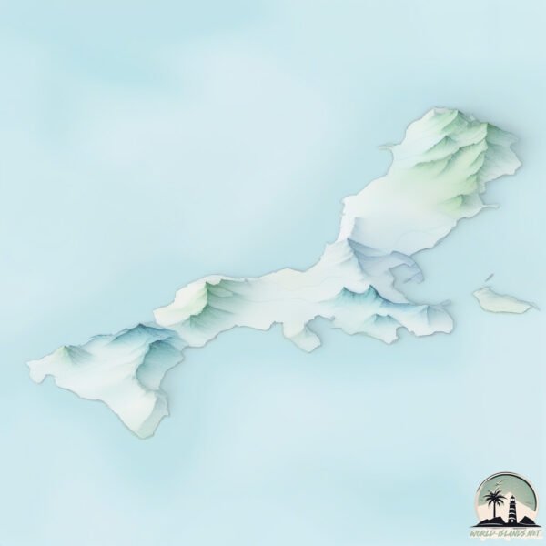
Geography and size of Kiska
Size: 290.2 km²
Coastline: 221.2 km
Ocean: Pacific Ocean
Sea: Bering Sea
Continent: North America
Kiska is a Large Island spanning 290 km² with a coastline of 221 km.
Archipel: Aleutian Islands – A chain of islands stretching from Alaska to Russia, known for their rugged beauty, abundant wildlife, and volcanic activity.
Tectonic Plate: Caribbean – Covering the Caribbean Sea and surrounding regions, this plate is bordered by the North American Plate and the South American Plate. Known for seismic activity, including earthquakes and volcanic eruptions, and features like the Puerto Rico Trench.
The geographic heart of the island is pinpointed at these coordinates:
Latitude: 51.97973222 / Longitude: 177.46839808
Climate and weather of Kiska
Climate Zone: Polar
Climate Details: Tundra
Temperature: Cold
Climate Characteristics: The tundra climate features long, extremely cold winters and short, cool summers. Vegetation is limited to mosses, lichens, and small shrubs due to the low temperatures and short growing seasons. Biodiversity is low, but some specialized species thrive.
Topography and nature of Kiska
Timezone: UTC-10:00
Timezone places:
Max. Elevation: 1108 m
Mean Elevation: 171 m
Vegetation: Herbaceous Cover
Tree Coverage: 43%
The mean elevation is 171 m. The highest elevation on the island reaches approximately 1108 meters above sea level. The island is characterized by Plateau: Elevated flatlands rising sharply above the surrounding area, with a maximum elevation over 500 meters but a mean elevation less than 300 meters, forming unique highland areas on islands.
Dominating Vegetation: Herbaceous Cover
Comprising mainly of grasses, herbs, and ferns, these areas are common in prairies, meadows, and savannas, and can vary widely in species composition. Kiska has a tree cover of 43 %.
Vegetation: 12 vegetation zones – Exceptionally Diverse Island
Islands with more than ten vegetation zones are among the most ecologically rich and varied in the world. These islands are akin to miniature continents, boasting an incredible array of ecosystems. The sheer range of habitats, from high peaks to deep valleys, rainforests to deserts, creates a mosaic of life that is unparalleled. They are crucial for conservation and ecological studies.
Infrastructure and Travelling to Kiska
Does the island have a public airport? no.
There is no public and scheduled airport on Kiska. The nearest airport is Ugolny Yuri Ryktheu Airport, located 1400 km away.
Does the island have a major port? no.
There are no major ports on Kiska. The closest major port is KISKA, approximately 1 km away.
The mean population of Kiska is 0 per km². Kiska is Uninhabited. The island belongs to United States of America.
Continuing your journey, Hawadoy is the next notable island, situated merely km away.
The Only Land Battle Fought on U.S. soil in WWII (Strange Stories)


United States of America is classified as Developed region: G7: Group of Seven – Major advanced economies, including Canada, France, Germany, Italy, Japan, the United Kingdom, and the United States. The level of income is High income: OECD.
News – Latest Updates and Headlines from Kiska
Stay informed with the most recent news and important headlines from Kiska. Here’s a roundup of the latest developments.
Please note: The data used here has been primarily extracted from satellite readings. Deviations from exact values may occur, particularly regarding the height of elevations and population density. Land area and coastline measurements refer to average values at mean high tide.