Ko Samui
Welcome to Ko Samui, a Tropical island in the Gulf of Thailand, part of the majestic Pacific Ocean. This guide offers a comprehensive overview of what makes Ko Samui unique – from its geography and climate to its population, infrastructure, and beyond. Dive into the details:
- Geography and Size: Explore the island’s size and location.
- Climate and Weather: Weather patterns and temperature.
- Topography and Nature: Uncover the natural wonders of the island.
- Infrastructure and Travelling: Insights on reaching, staying, and making the most of your visit.
- News and Headlines: Latest News.
Geography and size of Ko Samui
Size: 237.8 km²
Coastline: 92 km
Ocean: Pacific Ocean
Sea: Gulf of Thailand
Continent: Asia
Ko Samui is a Large Island spanning 238 km² with a coastline of 92 km.
Archipel: –
Tectonic Plate: Africa – One of the world’s largest tectonic plates, covering the African continent and parts of the surrounding oceans, known for its stability with some active rift zones.
The geographic heart of the island is pinpointed at these coordinates:
Latitude: 9.50479036 / Longitude: 99.99392591
Climate and weather of Ko Samui
Climate Zone: Tropical
Climate Details: Tropical Monsoon Climate
Temperature: Hot
Climate Characteristics: Characterized by heavy rainfall, high humidity, and uniformly high temperatures, but with a distinct short dry season. It features a seasonal reversal of prevailing wind directions.
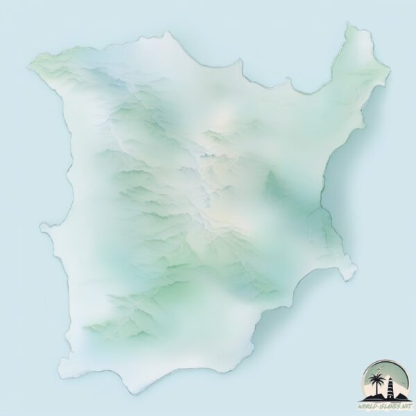
Topography and nature of Ko Samui
Timezone: UTC+07:00
Timezone places: Asia/Jakarta
Max. Elevation: 549 m
Mean Elevation: 136 m
Vegetation: Agricultural Mosaic
Tree Coverage: 38%
The mean elevation is 136 m. The highest elevation on the island reaches approximately 549 meters above sea level. The island is characterized by Plateau: Elevated flatlands rising sharply above the surrounding area, with a maximum elevation over 500 meters but a mean elevation less than 300 meters, forming unique highland areas on islands.
Dominating Vegetation: Agricultural Mosaic
A mix of cropland and natural vegetation, often seen in rural landscapes where agricultural fields are interspersed with patches of natural habitats. Ko Samui has a tree cover of 38 %.
Vegetation: 15 vegetation zones – Exceptionally Diverse Island
Islands with more than ten vegetation zones are among the most ecologically rich and varied in the world. These islands are akin to miniature continents, boasting an incredible array of ecosystems. The sheer range of habitats, from high peaks to deep valleys, rainforests to deserts, creates a mosaic of life that is unparalleled. They are crucial for conservation and ecological studies.
Infrastructure and Travelling to Ko Samui
Does the island have a public airport? yes.
Ko Samui has a public and scheduled airport. The following airports are located on this island: Samui Airport.
Does the island have a major port? no.
There are no major ports on Ko Samui. The closest major port is KHANOM, approximately 24 km away.
The mean population of Ko Samui is 195 per km². Ko Samui is Moderately Inhabited. The island belongs to Thailand.
Continuing your journey, Ko Phangan is the next notable island, situated merely km away.
The Complete Koh Samui Guide 2026: Why I Might Never Leave!
Thailand is classified as Emerging region: G20: Group of Twenty – Major economies comprising both developed and emerging countries, representing the world’s largest economies. The level of income is Upper middle income.
News – Latest Updates and Headlines from Ko Samui
Stay informed with the most recent news and important headlines from Ko Samui. Here’s a roundup of the latest developments.
Please note: The data used here has been primarily extracted from satellite readings. Deviations from exact values may occur, particularly regarding the height of elevations and population density. Land area and coastline measurements refer to average values at mean high tide.