Welcome to Komfane, a Tropical island in the Arafura Sea, part of the majestic Indian Ocean. This guide offers a comprehensive overview of what makes Komfane unique – from its geography and climate to its population, infrastructure, and beyond. Dive into the details:
Geography and size of Komfane
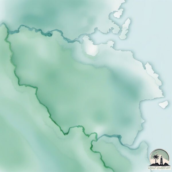
Size: 309.5 km²
Coastline: 127.5 km
Ocean: Indian Ocean
Sea: Arafura Sea
Continent: Oceania
Komfane is a Large Island spanning 310 km² with a coastline of 127 km.
Archipel: Melanesia – A subregion of Oceania in the southwestern Pacific Ocean, including countries like Fiji, Solomon Islands, and Vanuatu, known for their diverse cultures and languages.
Tectonic Plate: Banda Sea – A small plate in the eastern Indonesian region, known for complex interactions with the Australian and Pacific plates, leading to notable seismic and volcanic activity.
The geographic heart of the island is pinpointed at these coordinates:
Latitude: -5.64693994 / Longitude: 134.64667368
Climate and weather of Komfane
Climate Zone: Tropical
Climate Details: Tropical Rainforest Climate
Temperature: Hot
Climate Characteristics: This climate is typified by heavy rainfall throughout the year, high humidity, and consistently high temperatures, leading to lush rainforests and rich biodiversity. Seasonal temperature variations are minimal.
Topography and nature of Komfane
Timezone: UTC+09:00
Timezone places: Asia/Tokyo
Max. Elevation: 65 m
Mean Elevation: 31 m
Vegetation: Evergreen Broadleaf Forest
Tree Coverage: 59%
The mean elevation is 31 m. The highest elevation on the island reaches approximately 65 meters above sea level. The island is characterized by Plains: Flat, low-lying lands characterized by a maximum elevation of up to 200 meters. On islands, plains are typically coastal lowlands or central flat areas.
Dominating Vegetation: Evergreen Broadleaf Forest
Characterized by dense, lush canopies of broadleaf trees that retain their leaves year-round. These forests are typically found in tropical and subtropical regions and are known for their high biodiversity. Komfane has a tree cover of 59 %.
Vegetation: 12 vegetation zones – Exceptionally Diverse Island
Islands with more than ten vegetation zones are among the most ecologically rich and varied in the world. These islands are akin to miniature continents, boasting an incredible array of ecosystems. The sheer range of habitats, from high peaks to deep valleys, rainforests to deserts, creates a mosaic of life that is unparalleled. They are crucial for conservation and ecological studies.
Infrastructure and Travelling to Komfane
Does the island have a public airport? no.
There is no public and scheduled airport on Komfane. The nearest airport is Karel Sadsuitubun Airport, located 198 km away.
Does the island have a major port? no.
There are no major ports on Komfane. The closest major port is AMAMAPARE, approximately 262 km away.
The mean population of Komfane is 14 per km². Komfane is Gently Populated. The island belongs to Indonesia.
Continuing your journey, Pulau Aranlau is the next notable island, situated merely km away.
VISIT ONE OF THE WORLD'S MOST REMOTE ISLANDS: Fanning Island
Visit remote Fanning island - a small dot in the Pacific Ocean about 900 miles south of Hawaii. In the local language, Fanning ...VISIT ONE OF THE WORLD'S MOST REMOTE ISLANDS: Fanning Island
Visit remote Fanning island - a small dot in the Pacific Ocean about ...
Visit remote Fanning island - a small dot in the Pacific Ocean about 900 miles south of Hawaii. In the local language, Fanning ...
FANNING ISLAND: THE WORLD'S MOST REMOTE INHABITED ISLAND
VISIT THE WORLD'S MOST REMOTE INHABITED ISLAND - FANNING ISLAND OR ...
VISIT THE WORLD'S MOST REMOTE INHABITED ISLAND - FANNING ISLAND OR FANNING ATOLL (TABUAERON) Remote ...
Kiribati Island Travel Guide: Best Places to Visit In 2026
Top 5 Best Places to Visit In Kiribati Island Travel Guide! From ...
Top 5 Best Places to Visit In Kiribati Island Travel Guide! From Tarawa Atoll to Fanning Island to Abaiang to Christmas Island to ...
Welcome to Fanning Island!
Drone footage Fanning Island
This low lying coral atoll is being supplied by a sailing cargo ...
This low lying coral atoll is being supplied by a sailing cargo vessel: S.V. Kwai.
welcome welcome to Fanning Cable Lodge By Rakenta Touakin
Fanning Island Cable Lodge welcome song... written with love by Mr. ...
Fanning Island Cable Lodge welcome song... written with love by Mr. Mr. Beeto Areieta the cable lodge owner... King of the Virgin ...
Life in Tabuaeran, Fanning Island, Kiribati
Fanning Island, Kiribati, my 127th country! ::
http://www.Viviana.org Tabuaeran or "Tahanea" is known in English as Fanning ...
Arriving at Fanning island Kiribati did not land due to current
On the 51 day tales of the South Pacific Cruise Roundtrip from San ...
On the 51 day tales of the South Pacific Cruise Roundtrip from San Diego California #eriksshorts #hollandamerica #cruiseport ...
Fantasy Island | S01E01 (Pilot) (1977 - 1984)
Wealthy businesswoman Eunice Hollander Baines attends her own funeral; ...
Wealthy businesswoman Eunice Hollander Baines attends her own funeral; jaded hunter Paul Henley becomes the prey; World ...
Kiribati - Fanning Island
visit_kiribati_before_it_disappear Kiribati, a drowning paradise in ...
visit_kiribati_before_it_disappear Kiribati, a drowning paradise in the Central Pacific.
Best Day Fly Fishing Fanning Island Kiribati - 4K VLOG 141
This one is for you fly fishermen and women out there! If fly fishing ...
This one is for you fly fishermen and women out there! If fly fishing or viewing beautiful scenic shots of a gorgeous lagoon isn't ...
Fanning Island, Kiribati - Holland America Zaandam - Legendary Tales of the South Pacific Cruise
Join us on our 51 Day Legendary Tales of the South Pacific Cruise on ...
Join us on our 51 Day Legendary Tales of the South Pacific Cruise on the Holland America Zaandam! Follow us as we stop at ...
$28 budget friendly hotel in Bangkok, Thailand 🇹🇭
budget friendly hotel in Bangkok, Thailand.
budget friendly hotel in Bangkok, Thailand.
kabutiai @ Fanning Island #insta360
ファナヌ島・前編 FANANU ISLAND PART 1 【 ミクロネシア チューク Chuuk Micronesia 】
「太平洋に浮かぶ秘境の島旅」 今回はチューク州ホール諸島!空港もなければホテルもない、太平洋にポツリと浮かぶ島々です。
「太平洋に浮かぶ秘境の島旅」 今回はチューク州ホール諸島!空港もなければホテルもない、太平洋にポツリと浮かぶ島々です。
Mystery Of Fanning Island
WAS MOHAMED ATTA "CLOSE ASSOCIATE" IN FLORIDA A CIA PILOT?
WAS MOHAMED ATTA "CLOSE ASSOCIATE" IN FLORIDA A CIA PILOT?
Fanning Island
Fanning Island.
Fanning Island.
"Ancient Civilization Unearthed on Fanning Island"
Listen as we narrate a newspaper article from 1912 about a remarkable ...
Listen as we narrate a newspaper article from 1912 about a remarkable discovery on Fanning Island in the mid-Pacific! Over a ...
Adventure Time Back to Magical Fanning Island - 4K VLOG 177
After an unexpected adventure through Fiji, I was ultimately ...
After an unexpected adventure through Fiji, I was ultimately unsuccessful getting to Tarawa to see Chuck. After running out of ...
Mefier rhon Pafeng ngeni an Northwest epwe wor an NGO
Recorded on July 6, 2012 by Dr. Vid Raatior on Onoun during the ...
Recorded on July 6, 2012 by Dr. Vid Raatior on Onoun during the Northwest Education Leadership Symposium.
Fly Fishing Fanning Island in the Equatorial Pacific
Exploring Fanning Island in the Equatorial Pacific, one of our newest, ...
Exploring Fanning Island in the Equatorial Pacific, one of our newest, exciting signature fly fishing destinations.
Church day in Fananu island
Thank you to the ministry for keeping & spreading the gospel. Also ...
Thank you to the ministry for keeping & spreading the gospel. Also shout out to the singer's from Fananú island in the PAFENG ...
How Safe Is Kiribati?! 🇰🇮 #pacific #kiribati #fiji #vanuatu #betio #polynesia #fyp #viral #safe
Indonesia is classified as Emerging region: MIKT: Mexico, Indonesia, South Korea, and Turkey – Economies recognized for their development potential and emerging market status. The level of income is Lower middle income.
News – Latest Updates and Headlines from Komfane
Stay informed with the most recent news and important headlines from Komfane. Here’s a roundup of the latest developments.
Loading...
Please note: The data used here has been primarily extracted from satellite readings. Deviations from exact values may occur, particularly regarding the height of elevations and population density. Land area and coastline measurements refer to average values at mean high tide.