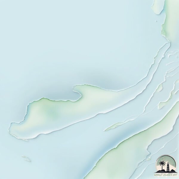
Welcome to Kugong Island, a Polar island in the Hudson Bay, part of the majestic Arctic Ocean. This guide offers a comprehensive overview of what makes Kugong Island unique – from its geography and climate to its population, infrastructure, and beyond. Dive into the details:
Geography and size of Kugong Island
Size: 324.7 km²
Coastline: 226.1 km
Ocean: Arctic Ocean
Sea: Hudson Bay
Continent: North America
Kugong Island is a Large Island spanning 325 km² with a coastline of 226 km.
Archipel: Belcher Islands – A group of islands in Canada’s Hudson Bay, known for their remote location and unique Inuit culture.
Tectonic Plate: North America – Covers North America and parts of the Atlantic and Arctic Oceans, characterized by diverse geological features and varying levels of seismic activity.
The geographic heart of the island is pinpointed at these coordinates:
Latitude: 56.29677662 / Longitude: -79.85609607
Climate and weather of Kugong Island
Climate Zone: Polar
Climate Details: Tundra
Temperature: Cold
Climate Characteristics: The tundra climate features long, extremely cold winters and short, cool summers. Vegetation is limited to mosses, lichens, and small shrubs due to the low temperatures and short growing seasons. Biodiversity is low, but some specialized species thrive.
Topography and nature of Kugong Island
Timezone: UTC-05:00
Timezone places: America/New_York
Max. Elevation: 41 m
Mean Elevation: 15 m
Vegetation: Herbaceous Cover
Tree Coverage: 20%
The mean elevation is 15 m. The highest elevation on the island reaches approximately 41 meters above sea level. The island is characterized by Plains: Flat, low-lying lands characterized by a maximum elevation of up to 200 meters. On islands, plains are typically coastal lowlands or central flat areas.
Dominating Vegetation: Herbaceous Cover
Comprising mainly of grasses, herbs, and ferns, these areas are common in prairies, meadows, and savannas, and can vary widely in species composition. Kugong Island has a tree cover of 20 %.
Vegetation: 5 vegetation zones – Highly Diverse Island
With five different vegetation zones, these islands offer a rich tapestry of ecosystems. The variety could include dense forests, open meadows, wetlands, coastal zones, and more. This level of diversity supports an intricate web of life, with each zone playing a vital role in the overall ecological health and balance of the island.
Infrastructure and Travelling to Kugong Island
Does the island have a public airport? no.
There is no public and scheduled airport on Kugong Island. The nearest airport is Sanikiluaq Airport, located 31 km away.
Does the island have a major port? no.
There are no major ports on Kugong Island. The closest major port is MICHIPICOTEN, approximately 1058 km away.
The mean population of Kugong Island is 0 per km². Kugong Island is Uninhabited. The island belongs to Canada.
Continuing your journey, Moore Island is the next notable island, situated merely km away.
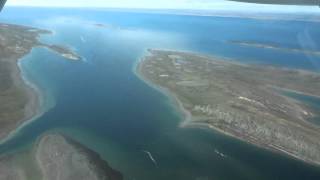
Belcher Islands: An Oasis in the Heart of Hudson Bay
Arctic Eider Society members Lisi Kavik-Mickiyuk and Joel Heath explain the unique geography of the Belcher Islands in Nunavut ...Belcher Islands: An Oasis in the Heart of Hudson Bay
Arctic Eider Society members Lisi Kavik-Mickiyuk and Joel Heath ...
Arctic Eider Society members Lisi Kavik-Mickiyuk and Joel Heath explain the unique geography of the Belcher Islands in Nunavut ...
Hudson Bay’s Oddly Shaped Island Archipelago | Canada's Strangest Islands: Part 2 | Belcher Islands
In this video we talk about the Belcher Islands, including its unique ...
In this video we talk about the Belcher Islands, including its unique geography, and grisly history, on this edition of Canada's ...
KD6WW/VY0 K9AJ/VY0 Flaherty Island Belcher Islands. From dxnews.com
KD6WW and K9AJ will be active from Flaherty Island, Belcher Islands, ...
KD6WW and K9AJ will be active from Flaherty Island, Belcher Islands, IOTA NA - 159, 26 - 29 August 2016 as KD6WW/VY0 and ...
Flaherty Island " in Sanikiluaq in Nunavut, Canada
Plateau of the rocky island in the water surface " Flaherty Island " ...
Plateau of the rocky island in the water surface " Flaherty Island " in Sanikiluaq in Nunavut, Canada. // Plateau der Felseninsel in ...
Residents of Sanikiluaq will soon have a new community space
Ajuinnata Wellness Project is led by the Ubluriak Society, a nonprofit ...
Ajuinnata Wellness Project is led by the Ubluriak Society, a nonprofit based in Sanikiluaq. They've turned five trailers into a new ...
Nunavut Community: Sanikiluaq (Belcher Islands) #Inuit #Facts #Inuktitut #WordOfTheDay #Nunavut
History of Sanikiluaq, my Great Great Grandfather!
Sanikiluaq #Canada #Inuit #History #Indigenous #proud.
Sanikiluaq #Canada #Inuit #History #Indigenous #proud.
Nunavut Diaries Part 3...From Winnipeg to Sanikiluaq
Final leg and the great step into the unknown boarding an aircraft in ...
Final leg and the great step into the unknown boarding an aircraft in Winnipeg for the 4 hour flight north and into the unknown and ...
Qikiqtait: Progress on a Community-driven protected area for the Belcher Islands Archipelago
Presented by ArcticNet 2020. Contributors Mick Appaqaq, Johnny ...
Presented by ArcticNet 2020. Contributors Mick Appaqaq, Johnny Kudluarok, Emily Kattuk, Johnnie Kuki, Joel Heath and ...
Rockhounding in Sanikiluaq Nunavut
Sanikiluaq is an Island in the South Hudson Bay 90 miles off the coast ...
Sanikiluaq is an Island in the South Hudson Bay 90 miles off the coast of Quebec and in the province of Nunavut Canada.
Gilutongan Island (Meron Silang Hotel)|Rixz Ivan Montero
GilutonganIsland #Hotel #rixzivanmontero gilutongan island gilutongan ...
GilutonganIsland #Hotel #rixzivanmontero gilutongan island gilutongan island problems and solutions gilutongan island ...
Sanikiluaq Cemetery
The cemetery at Sanikiluaq, Nunavut in the Belcher islands. Filmed 29 ...
The cemetery at Sanikiluaq, Nunavut in the Belcher islands. Filmed 29 Aug 2015.
Gas leak causes fly-in community of Sanikiluaq, Nunavut, to evacuate | APTN News
The community of Sanikiluaq in Nunavut was evacuated Monday afternoon ...
The community of Sanikiluaq in Nunavut was evacuated Monday afternoon after an apparent gas leak just after 1:30pm Eastern.
Sanikiluaq
Sanikiluaq, Nunavut, Canada Some general footage filmed with a Sony ...
Sanikiluaq, Nunavut, Canada Some general footage filmed with a Sony FDR X1000V 4K camera, and rendered out in 1080.
Arctic surfing in Sanikiluaq!
Had to get the plane ready in 50-90kmh winds which was a NIGHTMARE but ...
Had to get the plane ready in 50-90kmh winds which was a NIGHTMARE but we had time to pause for a little fun!
Sanikiluaq Town
A short video compilation of a visit to Sanikiluaq, Nunavut on 28 Aug ...
A short video compilation of a visit to Sanikiluaq, Nunavut on 28 Aug 2015. Features views of the town and harbour.
Charlie Takatak, Sharing Knowledge - Sanikiluaq
Charlie Takatak takes viewers on a trip to harvest mussels on the ...
Charlie Takatak takes viewers on a trip to harvest mussels on the Belcher Islands in Hudson's Bay in negative 50 degrees and ...
Tunnganarniq Nunagijavut - Sanikiluaq Eider Down Atigiik Making
Host Lisi Kavik-Mickiyuk shows us the process of creating coats from ...
Host Lisi Kavik-Mickiyuk shows us the process of creating coats from eider duck down. The first in a series of shows from ...
Drone video of Sanikiluaq October 2023
Eskimo Harbour
Eskimo Harbour is an inlet at Sanikiluaq, Nunavut in the Belcher ...
Eskimo Harbour is an inlet at Sanikiluaq, Nunavut in the Belcher islands. The shores are rich in black sand eroded from ancient ...
Sanikiluaq, Nunavut Vacation 12-19th September, 2022
Sanikiluaq Nunavut
Hiking trails.
Hiking trails.
Kuujjuarapik to Sanikiluaq
An Air Inuit flight (3H606) from YGW (Kuujjuarapik QC) to YSK ...
An Air Inuit flight (3H606) from YGW (Kuujjuarapik QC) to YSK (Sainikiluaq NU) on 28 August 2015. The aircraft is a DH Twin Otter ...
Canada is classified as Developed region: G7: Group of Seven – Major advanced economies, including Canada, France, Germany, Italy, Japan, the United Kingdom, and the United States. The level of income is High income: OECD.
News – Latest Updates and Headlines from Kugong Island
Stay informed with the most recent news and important headlines from Kugong Island. Here’s a roundup of the latest developments.
Loading...
Please note: The data used here has been primarily extracted from satellite readings. Deviations from exact values may occur, particularly regarding the height of elevations and population density. Land area and coastline measurements refer to average values at mean high tide.