L-Block
Welcome to L-Block, a Tropical island in the Bay of Bengal, part of the majestic Indian Ocean. This guide offers a comprehensive overview of what makes L-Block unique – from its geography and climate to its population, infrastructure, and beyond. Dive into the details:
- Geography and Size: Explore the island’s size and location.
- Climate and Weather: Weather patterns and temperature.
- Topography and Nature: Uncover the natural wonders of the island.
- Infrastructure and Travelling: Insights on reaching, staying, and making the most of your visit.
- News and Headlines: Latest News.
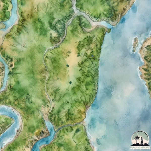
Geography and size of L-Block
Size: 36.7 km²
Coastline: 30.3 km
Ocean: Indian Ocean
Sea: Bay of Bengal
Continent: Asia
L-Block is a Medium Island spanning 37 km² with a coastline of 30 km.
Archipel: –
Tectonic Plate: India – A major tectonic plate that initially moved northward at a rapid pace before colliding with the Eurasian Plate. This collision is responsible for the uplift of the Himalayas and the Tibetan Plateau.
The geographic heart of the island is pinpointed at these coordinates:
Latitude: 21.75207478 / Longitude: 88.44801915
Climate and weather of L-Block
Climate Zone: Tropical
Climate Details: Tropical Savanna, Wet
Temperature: Hot
Climate Characteristics: Defined by distinct wet and dry seasons with high temperatures year-round. Pronounced rainfall occurs during the wet season, while the dry season is marked by drought.
Topography and nature of L-Block
Timezone: UTC+05:30
Timezone places: Asia/Kolkata
Max. Elevation: 4 m
Mean Elevation: 2 m
Vegetation: Agricultural Mosaic
Tree Coverage: 33%
The mean elevation is 2 m. The highest elevation on the island reaches approximately 4 meters above sea level. The island is characterized by Plains: Flat, low-lying lands characterized by a maximum elevation of up to 200 meters. On islands, plains are typically coastal lowlands or central flat areas.
Dominating Vegetation: Agricultural Mosaic
A mix of cropland and natural vegetation, often seen in rural landscapes where agricultural fields are interspersed with patches of natural habitats. L-Block has a tree cover of 33 %.
Vegetation: 9 vegetation zones – Very Highly Diverse Island
Islands in this range are ecological powerhouses, showcasing a wide array of vegetation zones. Each zone, from lush rainforests to arid scrublands, coastal mangroves to mountainous regions, contributes to a complex and interdependent ecosystem. These islands are often hotspots of biodiversity, supporting numerous species and intricate ecological processes.
Infrastructure and Travelling to L-Block
Does the island have a public airport? no.
There is no public and scheduled airport on L-Block. The nearest airport is Netaji Subhash Chandra Bose International Airport, located 95 km away.
Does the island have a major port? no.
There are no major ports on L-Block. The closest major port is HALDIA PORT, approximately 47 km away.
The mean population of L-Block is 1211 per km². L-Block is Densely Populated. The island belongs to India.
Continuing your journey, Sundarban is the next notable island, situated merely km away.
Block Island Day Trip Guide: Everything You Need To Know & Fun Facts Too!


India is classified as Emerging region: BRIC: Brazil, Russia, India, and China – Economies noted for their rapid growth and increasing influence on global affairs. The level of income is Lower middle income.
News – Latest Updates and Headlines from L-Block
Stay informed with the most recent news and important headlines from L-Block. Here’s a roundup of the latest developments.
Please note: The data used here has been primarily extracted from satellite readings. Deviations from exact values may occur, particularly regarding the height of elevations and population density. Land area and coastline measurements refer to average values at mean high tide.