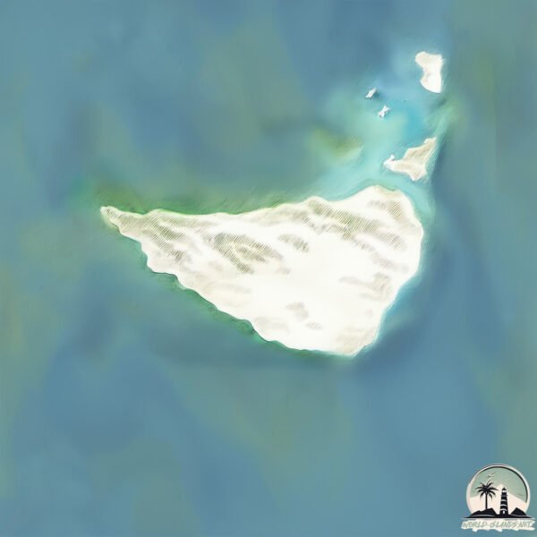
La Orchila
Welcome to La Orchila, a Dry island in the Caribbean Sea, part of the majestic Atlantic Ocean. This guide offers a comprehensive overview of what makes La Orchila unique – from its geography and climate to its population, infrastructure, and beyond. Dive into the details:
- Geography and Size: Explore the island’s size and location.
- Climate and Weather: Weather patterns and temperature.
- Topography and Nature: Uncover the natural wonders of the island.
- Infrastructure and Travelling: Insights on reaching, staying, and making the most of your visit.
- News and Headlines: Latest News.
Geography and size of La Orchila
Size: 43.1 km²
Coastline: 30.1 km
Ocean: Atlantic Ocean
Sea: Caribbean Sea
Continent: North America
La Orchila is a Medium Island spanning 43 km² with a coastline of 30 km.
Archipel: Lesser Antilles – A long arc of small islands in the Caribbean Sea, stretching from the Virgin Islands to Trinidad, known for their distinct cultures and tropical landscapes.
Tectonic Plate: Africa – One of the world’s largest tectonic plates, covering the African continent and parts of the surrounding oceans, known for its stability with some active rift zones.
The geographic heart of the island is pinpointed at these coordinates:
Latitude: 11.7979204 / Longitude: -66.14310487
Climate and weather of La Orchila
Climate Zone: Dry
Climate Details: Hot Semi-Arid (Steppe) Climate
Temperature: Hot
Climate Characteristics: Features hot summers and mild to warm winters. Receives more rainfall than hot deserts but less than tropical savannas, leading to a somewhat more varied landscape.
Topography and nature of La Orchila
Timezone: UTC-04:30
Timezone places: America/Caracas
Max. Elevation: 20 m
Mean Elevation: -1 m
Vegetation: Herbaceous Cover
Tree Coverage: 31%
The mean elevation is -1 m. The highest elevation on the island reaches approximately 20 meters above sea level. The island is characterized by Plains: Flat, low-lying lands characterized by a maximum elevation of up to 200 meters. On islands, plains are typically coastal lowlands or central flat areas.
Dominating Vegetation: Herbaceous Cover
Comprising mainly of grasses, herbs, and ferns, these areas are common in prairies, meadows, and savannas, and can vary widely in species composition. La Orchila has a tree cover of 31 %.
Vegetation: 10 vegetation zones – Very Highly Diverse Island
Islands in this range are ecological powerhouses, showcasing a wide array of vegetation zones. Each zone, from lush rainforests to arid scrublands, coastal mangroves to mountainous regions, contributes to a complex and interdependent ecosystem. These islands are often hotspots of biodiversity, supporting numerous species and intricate ecological processes.
Infrastructure and Travelling to La Orchila
Does the island have a public airport? no.
There is no public and scheduled airport on La Orchila. The nearest airport is Los Roques Airport, located 54 km away.
Does the island have a major port? no.
There are no major ports on La Orchila. The closest major port is LA GUAIRA, approximately 155 km away.
The mean population of La Orchila is per km². La Orchila is . The island belongs to Venezuela.
Continuing your journey, Tortuga is the next notable island, situated merely km away.
Venezuela holds extensive military drill on La Orchila’s Caribbean Island amid tensions with US


Venezuela is classified as Emerging region: G20: Group of Twenty – Major economies comprising both developed and emerging countries, representing the world’s largest economies. The level of income is Upper middle income.
News – Latest Updates and Headlines from La Orchila
Stay informed with the most recent news and important headlines from La Orchila. Here’s a roundup of the latest developments.
Please note: The data used here has been primarily extracted from satellite readings. Deviations from exact values may occur, particularly regarding the height of elevations and population density. Land area and coastline measurements refer to average values at mean high tide.