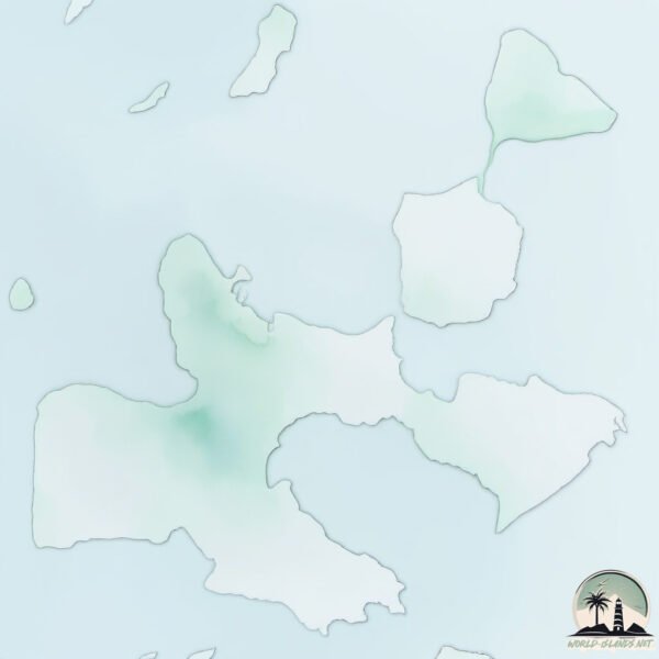
Welcome to Mahun, a Dry island in the Red Sea, part of the majestic Indian Ocean. This guide offers a comprehensive overview of what makes Mahun unique – from its geography and climate to its population, infrastructure, and beyond. Dive into the details:
Geography and size of Mahun
Size: 191.9 km²
Coastline: 158.3 km
Ocean: Indian Ocean
Sea: Red Sea
Continent: Africa
Mahun is a Large Island spanning 192 km² with a coastline of 158 km.
Archipel: Dahlak Archipelago – Located in the Red Sea near Eritrea, known for their historical significance, coral reefs, and diverse marine life.
Tectonic Plate: Africa – One of the world’s largest tectonic plates, covering the African continent and parts of the surrounding oceans, known for its stability with some active rift zones.
The geographic heart of the island is pinpointed at these coordinates:
Latitude: 16.0583255 / Longitude: 40.09807284
Climate and weather of Mahun
Climate Zone: Dry
Climate Details: Hot Deserts Climate
Temperature: Hot
Climate Characteristics: Dominated by extremely hot temperatures, this climate is marked by minimal rainfall and barren landscapes. Nights often experience drastic temperature drops.
Topography and nature of Mahun
Timezone: UTC+03:00
Timezone places: Asia/Riyadh
Max. Elevation: 16 m
Mean Elevation: 5 m
Vegetation: Sparse Vegetation
Tree Coverage: 46%
The mean elevation is 5 m. The highest elevation on the island reaches approximately 16 meters above sea level. The island is characterized by Plains: Flat, low-lying lands characterized by a maximum elevation of up to 200 meters. On islands, plains are typically coastal lowlands or central flat areas.
Dominating Vegetation: Sparse Vegetation
These regions have limited plant growth, typically due to extreme conditions like aridity or poor soils. Vegetation is scattered and consists of hardy plant species. Mahun has a tree cover of 46 %.
Vegetation: 8 vegetation zones – Very Highly Diverse Island
Islands in this range are ecological powerhouses, showcasing a wide array of vegetation zones. Each zone, from lush rainforests to arid scrublands, coastal mangroves to mountainous regions, contributes to a complex and interdependent ecosystem. These islands are often hotspots of biodiversity, supporting numerous species and intricate ecological processes.
Infrastructure and Travelling to Mahun
Does the island have a public airport? no.
There is no public and scheduled airport on Mahun. The nearest airport is Massawa International Airport, located 78 km away.
Does the island have a major port? no.
There are no major ports on Mahun. The closest major port is MITSIWA HARBOR, approximately 72 km away.
The mean population of Mahun is 5 per km². Mahun is Gently Populated. The island belongs to Eritrea.
Continuing your journey, Duladia is the next notable island, situated merely km away.
Mohun Creek | Trout Creek Waterfalls on Vancouver Island
Hello, and welcome to this video where we will be hiking to and photographing the beautiful Mohun Creek. Mohun Creek is a ...Mohun Creek | Trout Creek Waterfalls on Vancouver Island
Hello, and welcome to this video where we will be hiking to and ...
Hello, and welcome to this video where we will be hiking to and photographing the beautiful Mohun Creek. Mohun Creek is a ...
Mohun Lake Recreation Site Walkthru - Vancouver Island Camping
If you enjoy exploring Vancouver Island campgrounds please consider ...
If you enjoy exploring Vancouver Island campgrounds please consider subscribing to my channel. My goal is to document as ...
Underwater Volcanic Eruption | Submarine Volcano Lava Eruption 4K
Witness an incredible underwater volcanic eruption captured in ...
Witness an incredible underwater volcanic eruption captured in stunning 4K quality! See molten lava fountains erupting ...
Volcanic Eruption Caught on Camera: Witness the Unstoppable Force! #Volcano #Nature #Viral #Eruption
Experience the raw power of nature in this breathtaking footage of a ...
Experience the raw power of nature in this breathtaking footage of a volcanic eruption! Watch as a massive plume of ash and ...
tung tung tung sahur memes
Copyright Disclaimer under section 107 of the Copyright Act 1976, ...
Copyright Disclaimer under section 107 of the Copyright Act 1976, allowance is made for 'fair use' for purposes such as criticism, ...
Packraft & Camping On Mohun Island
The first official first trip with my Alpacka packraft and it was a ...
The first official first trip with my Alpacka packraft and it was a success. I camped on Mohun lake and everything was stellar.Enjoy!
MAALI DHIVEHISONG
First Ai Dhivehi language Song.
First Ai Dhivehi language Song.
TOP 5 - Mahón, Menorca, Spain - Things to See and Do 🇪🇸
Welcome to another video! This time from Mahón, the capital of Menorca ...
Welcome to another video! This time from Mahón, the capital of Menorca in Spain. Menorca belongs to Spain and is part of the ...
Who Are Yajuj and Majuj? And Where Are They Now? #islam #yajujmajuj #yajuj #religion #gogandmagog
EVERYBODY GOT A BIG BRO 😁
Guide to Hiking Trout Creek Falls and Mohun Creek Trail
Trout Creek Falls on the Mohun Creek Trail is a moderate hike near ...
Trout Creek Falls on the Mohun Creek Trail is a moderate hike near Campbell River on Northern Vancouver Island. There is not ...
KIDS BOXING #competition #island #andaman #southandaman
Roumadyval - Baselaia Ne Wetr - Clip officiel
Roumadyval - Baselaia Ne Wetr - Clip officiel ...
Morton Lake Provincial Park and Mohun Lake - Vancouver Island, B.C. Canada.
Paddle Boarding Mohun Lake, Vancouver Island
Mohun Lake is north of Campbell River by 20 minutes and the lake has ...
Mohun Lake is north of Campbell River by 20 minutes and the lake has multiple locations to launch boats from.
Biggest Losses of Kerala Blaster💛🐘
"Kerala Blasters' Biggest Losses: A Look Back at the Yellow Brigade's ...
"Kerala Blasters' Biggest Losses: A Look Back at the Yellow Brigade's Toughest Defeats"* Relive the most heartbreaking losses in ...
Ronaldo's Skills Have Not Changed 🥶
football #shorts #cristianoronaldo #ronaldo #skills #moments.
football #shorts #cristianoronaldo #ronaldo #skills #moments.
Guess the island (medium) #spain #island #france #italy #india #germany #uk #usa #funny #ocean #land
The Faroe Islands are a group of 18 islands in the North Atlantic Ocean between Scotland and Iceland
Relax with the calming beauty of nature Gentle sounds, peaceful vibes, ...
Relax with the calming beauty of nature Gentle sounds, peaceful vibes, and pure serenity. #Nature #RelaxingSounds ...
As a Muslim ,where in China is the best place for your first trip. It’s definitely Yunnan.
Portugal vs India World Cup Quarterfinal 2026 imaginary
shorts #football #ronaldo.
shorts #football #ronaldo.
Paying Your Filipina Girlfriend.
Part of a longer video about freeloading filipinas. #filipinas ...
Part of a longer video about freeloading filipinas. #filipinas #foreigner #philippines.
Motu patlu cartoon। Motu patlu potty video🤣 tom and moto patlu #motupatlu #cartoon #moto #tom #jerry
Match Highlights | Mohun Bagan Super Giant 2-0 FC Goa | MW 26 | ISL 2024-25
mohunbagansupergiant delivered a statement win against @fcgoaofficial ...
mohunbagansupergiant delivered a statement win against @fcgoaofficial ahead of their #ISLShield celebrations in #MBSGFCG!
Emiliano Martinez Is In Kolkata Mohun Bagan Ground #shorts #emilianomartínez #mohunbagan
Eritrea is classified as Least developed region: Countries that exhibit the lowest indicators of socioeconomic development, with the lowest Human Development Index ratings. The level of income is Low income.
News – Latest Updates and Headlines from Mahun
Stay informed with the most recent news and important headlines from Mahun. Here’s a roundup of the latest developments.
Loading...
Please note: The data used here has been primarily extracted from satellite readings. Deviations from exact values may occur, particularly regarding the height of elevations and population density. Land area and coastline measurements refer to average values at mean high tide.