Margarita
Welcome to Margarita, a Dry island in the Caribbean Sea, part of the majestic Atlantic Ocean. This guide offers a comprehensive overview of what makes Margarita unique – from its geography and climate to its population, infrastructure, and beyond. Dive into the details:
- Geography and Size: Explore the island’s size and location.
- Climate and Weather: Weather patterns and temperature.
- Topography and Nature: Uncover the natural wonders of the island.
- Infrastructure and Travelling: Insights on reaching, staying, and making the most of your visit.
- News and Headlines: Latest News.
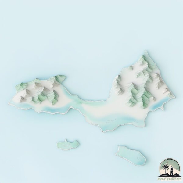
Geography and size of Margarita
Size: 935.6 km²
Coastline: 291.7 km
Ocean: Atlantic Ocean
Sea: Caribbean Sea
Continent: North America
Margarita is a Large Island spanning 936 km² with a coastline of 292 km.
Archipel: Lesser Antilles – A long arc of small islands in the Caribbean Sea, stretching from the Virgin Islands to Trinidad, known for their distinct cultures and tropical landscapes.
Tectonic Plate: Caribbean – Covering the Caribbean Sea and surrounding regions, this plate is bordered by the North American Plate and the South American Plate. Known for seismic activity, including earthquakes and volcanic eruptions, and features like the Puerto Rico Trench.
The geographic heart of the island is pinpointed at these coordinates:
Latitude: 11.00111285 / Longitude: -64.05022867
Climate and weather of Margarita
Climate Zone: Dry
Climate Details: Hot Semi-Arid (Steppe) Climate
Temperature: Hot
Climate Characteristics: Features hot summers and mild to warm winters. Receives more rainfall than hot deserts but less than tropical savannas, leading to a somewhat more varied landscape.
Topography and nature of Margarita
Timezone: UTC-04:30
Timezone places: America/Caracas
Max. Elevation: 762 m
Mean Elevation: 84 m
Vegetation: Herbaceous Cover
Tree Coverage: 25%
The mean elevation is 84 m. The highest elevation on the island reaches approximately 762 meters above sea level. The island is characterized by Plateau: Elevated flatlands rising sharply above the surrounding area, with a maximum elevation over 500 meters but a mean elevation less than 300 meters, forming unique highland areas on islands.
Dominating Vegetation: Herbaceous Cover
Comprising mainly of grasses, herbs, and ferns, these areas are common in prairies, meadows, and savannas, and can vary widely in species composition. Margarita has a tree cover of 25 %.
Vegetation: 16 vegetation zones – Exceptionally Diverse Island
Islands with more than ten vegetation zones are among the most ecologically rich and varied in the world. These islands are akin to miniature continents, boasting an incredible array of ecosystems. The sheer range of habitats, from high peaks to deep valleys, rainforests to deserts, creates a mosaic of life that is unparalleled. They are crucial for conservation and ecological studies.
Infrastructure and Travelling to Margarita
Does the island have a public airport? yes.
Margarita has a public and scheduled airport. The following airports are located on this island: Del Caribe Santiago Mariño International Airport.
Does the island have a major port? yes.
Margarita is home to a major port. The following ports are situated on the island: .
The mean population of Margarita is 621 per km². Margarita is Densely Populated. The island belongs to Venezuela.
The name of the island resonates across different cultures and languages. Here is how it is known around the world: Arabic: جزيرة مارغريتا; German: Isla Margarita; Spanish: Isla de Margarita; French: Île Margarita; Portuguese: Ilha de Margarita; Russian: Маргарита; Chinese: 玛格丽塔岛
Continuing your journey, Coche is the next notable island, situated merely km away.
MARGARITA Venezuela - The Most Beautiful Island in the Caribbean - Best Things To Do and Visit 2025


Venezuela is classified as Emerging region: G20: Group of Twenty – Major economies comprising both developed and emerging countries, representing the world’s largest economies. The level of income is Upper middle income.
News – Latest Updates and Headlines from Margarita
Stay informed with the most recent news and important headlines from Margarita. Here’s a roundup of the latest developments.
Please note: The data used here has been primarily extracted from satellite readings. Deviations from exact values may occur, particularly regarding the height of elevations and population density. Land area and coastline measurements refer to average values at mean high tide.