Marikaban
Welcome to Marikaban, a Tropical island in the Philippine Sea, part of the majestic Pacific Ocean. This guide offers a comprehensive overview of what makes Marikaban unique – from its geography and climate to its population, infrastructure, and beyond. Dive into the details:
- Geography and Size: Explore the island’s size and location.
- Climate and Weather: Weather patterns and temperature.
- Topography and Nature: Uncover the natural wonders of the island.
- Infrastructure and Travelling: Insights on reaching, staying, and making the most of your visit.
- News and Headlines: Latest News.
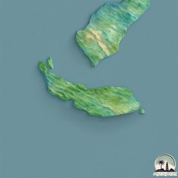
Geography and size of Marikaban
Size: 32.6 km²
Coastline: 36.2 km
Ocean: Pacific Ocean
Sea: Philippine Sea
Continent: Asia
Marikaban is a Medium Island spanning 33 km² with a coastline of 36 km.
Archipel: Malay Archipelago – The world’s largest archipelago, located between mainland Southeast Asia and Australia, known for its immense biodiversity and cultural diversity.
Tectonic Plate: Sunda – Extends across Southeast Asia, encompassing parts of the Sunda Shelf, known for its interaction with the Australian Plate, contributing to volcanic activity in Indonesia.
The geographic heart of the island is pinpointed at these coordinates:
Latitude: 13.64760234 / Longitude: 120.8926142
Climate and weather of Marikaban
Climate Zone: Tropical
Climate Details: Tropical Monsoon Climate
Temperature: Hot
Climate Characteristics: Characterized by heavy rainfall, high humidity, and uniformly high temperatures, but with a distinct short dry season. It features a seasonal reversal of prevailing wind directions.
Topography and nature of Marikaban
Timezone: UTC+08:00
Timezone places: Australia/Perth
Max. Elevation: 348 m
Mean Elevation: 120 m
Vegetation: Evergreen Broadleaf Forest
Tree Coverage: 79%
The mean elevation is 120 m. The highest elevation on the island reaches approximately 348 meters above sea level. The island is characterized by Hills: Gently sloping landforms with rounded tops, having a maximum elevation between 200 and 500 meters. Hills contribute to a varied landscape on islands.
Dominating Vegetation: Evergreen Broadleaf Forest
Characterized by dense, lush canopies of broadleaf trees that retain their leaves year-round. These forests are typically found in tropical and subtropical regions and are known for their high biodiversity. Marikaban has a tree cover of 79 %.
Vegetation: 8 vegetation zones – Very Highly Diverse Island
Islands in this range are ecological powerhouses, showcasing a wide array of vegetation zones. Each zone, from lush rainforests to arid scrublands, coastal mangroves to mountainous regions, contributes to a complex and interdependent ecosystem. These islands are often hotspots of biodiversity, supporting numerous species and intricate ecological processes.
Infrastructure and Travelling to Marikaban
Does the island have a public airport? no.
There is no public and scheduled airport on Marikaban. The nearest airport is Ninoy Aquino International Airport, located 94 km away.
Does the island have a major port? no.
There are no major ports on Marikaban. The closest major port is BATANGAS CITY, approximately 17 km away.
The mean population of Marikaban is 363 per km². Marikaban is Moderately Inhabited. The island belongs to Philippines.
Continuing your journey, Verde is the next notable island, situated merely km away.
Magic of Marikaban Island, Philippines!.


Philippines is classified as Emerging region: G20: Group of Twenty – Major economies comprising both developed and emerging countries, representing the world’s largest economies. The level of income is Lower middle income.
News – Latest Updates and Headlines from Marikaban
Stay informed with the most recent news and important headlines from Marikaban. Here’s a roundup of the latest developments.
- Tingloy Island turns tide vs garbage - Inquirer.neton 24 April 2025
Tingloy Island turns tide vs garbage Inquirer.net
- Turning plastics into cash - Daily Tribuneon 20 April 2025
Turning plastics into cash Daily Tribune
- 6 motorcycle-friendly spots to help you beat the summer heat - zigwheels.phon 26 March 2025
6 motorcycle-friendly spots to help you beat the summer heat zigwheels.ph
- BPI Boracay 200, 2024 - Sail-World.comon 18 March 2024
BPI Boracay 200, 2024 Sail-World.com
- Philippine Cargo Vessel Disabled After Fire - The Maritime Executiveon 1 March 2023
Philippine Cargo Vessel Disabled After Fire The Maritime Executive
- Cebu spends P10M for solar street lights - Inquirer.neton 10 March 2022
Cebu spends P10M for solar street lights Inquirer.net
Please note: The data used here has been primarily extracted from satellite readings. Deviations from exact values may occur, particularly regarding the height of elevations and population density. Land area and coastline measurements refer to average values at mean high tide.