Welcome to Meanguera del Golfo, a Tropical island in the North Pacific Ocean, part of the majestic Pacific Ocean. This guide offers a comprehensive overview of what makes Meanguera del Golfo unique – from its geography and climate to its population, infrastructure, and beyond. Dive into the details:
Geography and size of Meanguera del Golfo
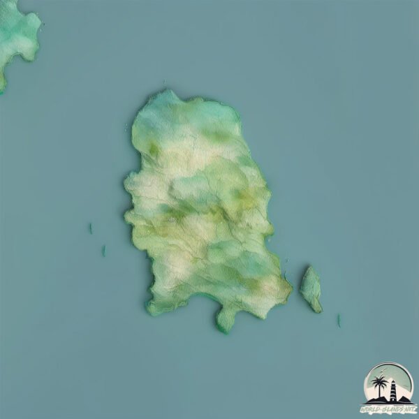
Size: 16.6 km²
Coastline: 21.6 km
Ocean: Pacific Ocean
Sea: North Pacific Ocean
Continent: North America
Meanguera del Golfo is a Medium Island spanning 17 km² with a coastline of 22 km.
Archipel: –
Tectonic Plate: Caribbean – Covering the Caribbean Sea and surrounding regions, this plate is bordered by the North American Plate and the South American Plate. Known for seismic activity, including earthquakes and volcanic eruptions, and features like the Puerto Rico Trench.
The geographic heart of the island is pinpointed at these coordinates:
Latitude: 13.19017379 / Longitude: -87.71144261
Climate and weather of Meanguera del Golfo
Climate Zone: Tropical
Climate Details: Tropical Savanna, Wet
Temperature: Hot
Climate Characteristics: Defined by distinct wet and dry seasons with high temperatures year-round. Pronounced rainfall occurs during the wet season, while the dry season is marked by drought.
Topography and nature of Meanguera del Golfo
Timezone: UTC-06:00
Timezone places: America/Chicago
Max. Elevation: 323 m
Mean Elevation: 167 m
Vegetation: Deciduous Broadleaf Forest
Tree Coverage: 49%
The mean elevation is 167 m. The highest elevation on the island reaches approximately 323 meters above sea level. The island is characterized by Hills: Gently sloping landforms with rounded tops, having a maximum elevation between 200 and 500 meters. Hills contribute to a varied landscape on islands.
Dominating Vegetation: Deciduous Broadleaf Forest
Composed of broadleaf trees that shed their leaves seasonally. These forests are commonly found in temperate zones and experience distinct seasonal changes. Meanguera del Golfo has a tree cover of 49 %.
Vegetation: 8 vegetation zones – Very Highly Diverse Island
Islands in this range are ecological powerhouses, showcasing a wide array of vegetation zones. Each zone, from lush rainforests to arid scrublands, coastal mangroves to mountainous regions, contributes to a complex and interdependent ecosystem. These islands are often hotspots of biodiversity, supporting numerous species and intricate ecological processes.
Infrastructure and Travelling to Meanguera del Golfo
Does the island have a public airport? no.
There is no public and scheduled airport on Meanguera del Golfo. The nearest airport is Toncontín International Airport, located 109 km away.
Does the island have a major port? no.
There are no major ports on Meanguera del Golfo. The closest major port is LA UNION, approximately 18 km away.
The mean population of Meanguera del Golfo is 67 per km². Meanguera del Golfo is Gently Populated. The island belongs to El Salvador.
Continuing your journey, Tigre is the next notable island, situated merely km away.
Isla Meanguera del Golfo, #launión
Isla Meanguera del Golfo, #launión
Isla Meanguera, Golfo de Fonseca
Recorrido por el Golfo de Fonseca visitando los alrededores de la isla ...
Recorrido por el Golfo de Fonseca visitando los alrededores de la isla de Meanguera del Golfo.
Island camping and #exploration, Meanguera Island, El Salvador
A friends & family overnight trip to Meanguera island. Star gazing, ...
A friends & family overnight trip to Meanguera island. Star gazing, sunset and sunrise from the middle of Golfo de Fonseca.
MEANGUERA ISLAND TOUR AND FISHING
The Southern Islands tour of Golfo de Fonseca, meets Meanguera, ...
The Southern Islands tour of Golfo de Fonseca, meets Meanguera, Conchaguita and Pirigallo Islands. Amazing photography al ...
Meanguera Del Golfo, La Union El Salvador— tour completo por toda la Isla
Un tour desde la playa El Peladero rodeandonla la isla Meanguera Del ...
Un tour desde la playa El Peladero rodeandonla la isla Meanguera Del Golfo, pasando por Salvadorfito, isla Pirigallo donde se ...
MEANGUERA DEL GOLFO-www.reynatours.com
Vista de la isla de Meanguera del Golfo-La Unión- El Salvador.
Vista de la isla de Meanguera del Golfo-La Unión- El Salvador.
La Ruta del Zapamiche - A Wild Ride to Meanguera Island, La Unión - El Salvador
An Amazing trip to the islands of the Gulf of Fonseca. Visit ...
An Amazing trip to the islands of the Gulf of Fonseca. Visit Meanguera, Pirigallo, Martin Perez, Ilca, Conchaguita, and Zacatillo ...
Isla Meanguera del Golfo. Una frontera acuática (2006)
Serie: Medio Ambiente/ Islas Primera emisión: 5 de octubre de 2006 ...
Serie: Medio Ambiente/ Islas Primera emisión: 5 de octubre de 2006 Ubicada en La Unión, a más de 200 kilómetros de San ...
El Golfo de Fonseca Isla Meanguera El Salvador 2019
Viaje a la Isla de Meanguera en El Golfo de Fonseca cerca de los ...
Viaje a la Isla de Meanguera en El Golfo de Fonseca cerca de los países vecinos Honduras y Nicaragua, muy buena experiencia.
Isla Meanguera del Golfo.
En El Salvador Isla Meanguera del Golfo un paraíso
meanguera del golfo
Viaje de Turismo para conocer lo bello que es la isla un lugar muy ...
Viaje de Turismo para conocer lo bello que es la isla un lugar muy especial y su gente encantadora.
El Salvador, Meanguera del Golfo Island, Gulf of Fonseca, La Union,, Tourist Info, Central America
I hope you find my information useful. Subscribe. THANKS! Isla ...
I hope you find my information useful. Subscribe. THANKS! Isla Meanguera del Golfo Golfo de Fonseca #centralamerica ...
En Meanguera del Golfo Agua del Mar en Agua Potable
Los habitantes de la isla Meanguera del Golfo, ubicada en La Unión ...
Los habitantes de la isla Meanguera del Golfo, ubicada en La Unión Sur, están a punto de experimentar un cambio significativo ...
Así luce la isla de meanguera de golfo de la unión
LA BELLA ISLA DE MEANGUERA DEL GOLFO, LA UNION EL SALVADOR
MEANGUERA DEL GOLFO.Alojamiento-Restaurante-www.reynatours.com
Alojamiento y restaurante en la isla Meanguera del Golfo, El Salvador.
Alojamiento y restaurante en la isla Meanguera del Golfo, El Salvador.
Rumbo a Meanguera del Golfo - La Unión - El Salvador C.A.
Así se viaja en lancha desde El embarcadero Los Coquitos en La Unión ...
Así se viaja en lancha desde El embarcadero Los Coquitos en La Unión hacia la Isla Meanguera del Golfo perteneciente al ...
La Ruta del Zapamiche - Traveling to Meanguera Island, La Unión. El Salvador
An Amazing trip to the islands of the Gulf of Fonseca. Visit ...
An Amazing trip to the islands of the Gulf of Fonseca. Visit Meanguera, Pirigallo, Martin Perez, Ilca, Conchaguita, and Zacatillo ...
Meanguera del Golfo
Una experiencia de vida de los habitantes de la Isla de Meanguera del ...
Una experiencia de vida de los habitantes de la Isla de Meanguera del Golfo Departamento de La Unión, El Salvador,.
Viaje a Isla de meanguera del golfo la unión El salvador 💯
Visita a la Isla Meanguera
Visita a la Isla Meanguera del Golfo en El Salvador ...
Visita a la Isla Meanguera del Golfo en El Salvador ------------------------------------------------------------------- Web: ...
El Salvador isla paradisíaca Meanguera del Golfo
Impresionante Isla Meanguera del Golfo en El Salvador #GolfodeFonseca ...
Impresionante Isla Meanguera del Golfo en El Salvador #GolfodeFonseca #ElSalvador Video: Facebook ...
Meanguera del Golfo 1
Audiovisuales y todo lo relacionado a publicidad digital, puedes ...
Audiovisuales y todo lo relacionado a publicidad digital, puedes visitar nuestra pagina en facebook: ...
Conoce a Manuel, comerciante de la isla Meanguera del Golfo. #HuellaAES
El Salvador is classified as Developing region: Regions characterized by lower income levels, with economies in the process of industrialization and modernization. The level of income is Lower middle income.
News – Latest Updates and Headlines from Meanguera del Golfo
Stay informed with the most recent news and important headlines from Meanguera del Golfo. Here’s a roundup of the latest developments.
Loading...
Please note: The data used here has been primarily extracted from satellite readings. Deviations from exact values may occur, particularly regarding the height of elevations and population density. Land area and coastline measurements refer to average values at mean high tide.