Welcome to Paros, a Temperate island in the Aegean Sea, part of the majestic Atlantic Ocean. This guide offers a comprehensive overview of what makes Paros unique – from its geography and climate to its population, infrastructure, and beyond. Dive into the details:
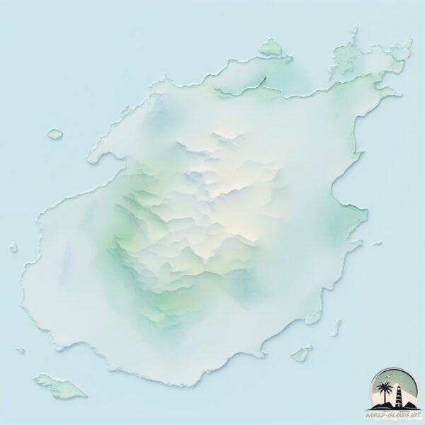
Geography and size of Paros
Size: 197.8 km²
Coastline: 105 km
Ocean: Atlantic Ocean
Sea: Aegean Sea
Continent: Europe
Paros is a Large Island spanning 198 km² with a coastline of 105 km.
Archipel: Cyclades – A group of islands in the Aegean Sea, part of Greece, known for their iconic white-washed architecture, beautiful beaches, and rich history.
Tectonic Plate: Eurasia – One of the world’s largest tectonic plates, the Eurasian Plate covers a significant portion of Europe and Asia. It’s characterized by diverse geological features, including the Ural Mountains, the European Plain, and the Himalayas formed from its collision with the Indian Plate.
The geographic heart of the island is pinpointed at these coordinates:
Latitude: 37.059498 / Longitude: 25.19237106
Climate and weather of Paros
Climate Zone: Temperate
Climate Details: Hot-Summer Mediterranean Climate
Temperature: Hot Summer
Climate Characteristics: Characterized by hot, dry summers and mild, wet winters, typical of coastal areas with abundant sunshine.
Topography and nature of Paros
Timezone: UTC+02:00
Timezone places: Europe/Mariehamn
Max. Elevation: 649 m
Mean Elevation: 140 m
Vegetation: Agricultural Mosaic
Tree Coverage: 14%
The mean elevation is 140 m. The highest elevation on the island reaches approximately 649 meters above sea level. The island is characterized by Plateau: Elevated flatlands rising sharply above the surrounding area, with a maximum elevation over 500 meters but a mean elevation less than 300 meters, forming unique highland areas on islands.
Dominating Vegetation: Agricultural Mosaic
A mix of cropland and natural vegetation, often seen in rural landscapes where agricultural fields are interspersed with patches of natural habitats. Paros has a tree cover of 14 %.
Vegetation: 12 vegetation zones – Exceptionally Diverse Island
Islands with more than ten vegetation zones are among the most ecologically rich and varied in the world. These islands are akin to miniature continents, boasting an incredible array of ecosystems. The sheer range of habitats, from high peaks to deep valleys, rainforests to deserts, creates a mosaic of life that is unparalleled. They are crucial for conservation and ecological studies.
Infrastructure and Travelling to Paros
Does the island have a public airport? yes.
Paros has a public and scheduled airport. The following airports are located on this island: Paros National Airport.
Does the island have a major port? no.
There are no major ports on Paros. The closest major port is NISOS NAXOS, approximately 9 km away.
The mean population of Paros is 68 per km². Paros is Gently Populated. The island belongs to Greece.
The name of the island resonates across different cultures and languages. Here is how it is known around the world: Arabic: باروس; German: Paros; Spanish: Paros; French: Paros; Portuguese: Paros; Russian: Парос; Chinese: 帕罗斯岛
Continuing your journey, Nisí Antíparos is the next notable island, situated merely km away.
The Greek Island That Has It All | Paros, Greece
Paros, Greece is truly the Greek Island that has it all! From its stunning beaches to its picturesque towns, no wonder it's the island ...The Greek Island That Has It All | Paros, Greece
Paros, Greece is truly the Greek Island that has it all! From its ...
Paros, Greece is truly the Greek Island that has it all! From its stunning beaches to its picturesque towns, no wonder it's the island ...
7 Days In PAROS, GREECE | A Travel Itinerary (without a car!)
See how you could spend 7 days on the stunning island of Paros, ...
See how you could spend 7 days on the stunning island of Paros, Greece! Our itinerary will take you through sandy beaches, ...
Paros vs Naxos, which Greek island should you choose? #greecetravel #paros #naxos
Paros vs. Naxos: Which Island Wins? 🏛️ After 6 trips to Greece and 10 ...
Paros vs. Naxos: Which Island Wins? 🏛️ After 6 trips to Greece and 10 islands, I've narrowed it down: if you only have 3 extra ...
PAROS Greece 2025 Travel Guide | BEST Beaches and TOP Tips
Paros, one of the many Greek islands in the Aegean Sea, is a hidden ...
Paros, one of the many Greek islands in the Aegean Sea, is a hidden gem that often gets overshadowed by its more famous ...
🔥 PAROS ISLAND SECRETS: Where to Stay, Eat & Party Like a Local! 🇬🇷 #bestofeurope #paros #greece
Discover the REAL Paros beyond the postcards! ✨ Get insider tips on ...
Discover the REAL Paros beyond the postcards! ✨ Get insider tips on hidden gems, best beaches, and where to find the most ...
How to Spend 3 Days in PAROS Greece | Travel Itinerary
Get ready to explore the stunning beauty of Paros, Greece! We're ...
Get ready to explore the stunning beauty of Paros, Greece! We're excited to bring you the ultimate guide for an amazing three-day ...
Complete travel guide to Paros Island
ParosIsland #GreekIslandVibes #TravelParadise #ExploreGreece.
ParosIsland #GreekIslandVibes #TravelParadise #ExploreGreece.
Paros Greece: 8 Best Things to Do In Paros Greece
Paros Greece is a sun-drenched Cycladic gem overflowing with timeless ...
Paros Greece is a sun-drenched Cycladic gem overflowing with timeless beauty, seaside charm, and cultural treasures. In this ...
5-day itinerary for Paros island in Greece . The best things to do if you have 5 days to spend on
5-day itinerary for Paros island in Greece . The best things to do if ...
5-day itinerary for Paros island in Greece . The best things to do if you have 5 days to spend on Paros. Want more Paros tips?
🔥 PAROS ISLAND: The TRUTH About Popular Spots Local Secrets Revealed! 🇬🇷#bestofeurope #worldexplorer
Discover the REAL best places in Paros - plus one major tourist trap ...
Discover the REAL best places in Paros - plus one major tourist trap to avoid! ✨ ✓ HIDDEN GEM HOTEL: Palio Milos Hotel ...
PAROS Greece | Ultimate Paros Island Travel Guide Vlog 2024
Discover the beauty of PAROS Greece with this comprehensive Paros ...
Discover the beauty of PAROS Greece with this comprehensive Paros travel guide, showcasing the best of the stunning Paros ...
PAROS Travel Guide: Top 10 Things To Do 🏝️🇬🇷 (Popular Island in Greece!)
PAROS, Greece: Here are our 10 TOP places to see and do on the ...
PAROS, Greece: Here are our 10 TOP places to see and do on the majestic getaway Greek Island, a short ferry ride away from ...
Paros Hotels and Where To Stay in Naoussa, Parikia, & Beaches - Greece
The best hotels in Paros, Greece and where to stay on this beautiful ...
The best hotels in Paros, Greece and where to stay on this beautiful Cycladic Island that's only 2 hours by ferry from Santorini and ...
Naxos, Paros, or Milos: Which one should you choose?
We're comparing Naxos, Paros, and Milos to pick the best Greek island ...
We're comparing Naxos, Paros, and Milos to pick the best Greek island for you! From Naxos' sandy beaches and hikes to ...
PAROS - The Prettiest Greek Island | Greece Travel Guide
PAROS has to be one of the prettiest Greek Islands with the beautiful ...
PAROS has to be one of the prettiest Greek Islands with the beautiful fishing village of Naoussa and mountain town of Lefkes, it's a ...
Why PAROS Might Be the BEST Island in Greece (2-Day Itinerary)
Join us as we explore Paros Island, one of the stunning Cyclades ...
Join us as we explore Paros Island, one of the stunning Cyclades Islands known for its pristine Paros beaches and charming ...
Is Paros still worth the hype? #paros #greekislands #tlbtips
Paros Island | Greece 🇬🇷 4K | #greek #travel #paros #beautifuldestinations #amazing #relaxing #opa
3 Days in PAROS, GREECE 😍 Must Visit Greek Island
Welcome to one of the most underrated Greek islands! I'm now on the ...
Welcome to one of the most underrated Greek islands! I'm now on the stunning Greek island of Paros which is a place where ...
Looking for a mini villa on Paros island, Greece with private jacuzzi pool? Past few days we were in
Looking for a mini villa on Paros island, Greece with private jacuzzi ...
Looking for a mini villa on Paros island, Greece with private jacuzzi pool? Past few days we were invited to stay at the brand new ...
2 Days in Paros 🇬🇷 The Most Affordable Greek Island!
This was our first ever Greek island, and Paros set the bar incredibly ...
This was our first ever Greek island, and Paros set the bar incredibly high. We spent two days exploring the island on a scooter.
Paros Island: The Greek Island You Didn't Know About
Top Things to do in Paros, Greece | Paros Travel Guide
Paros | Straight to the Point Guide
This is what you need to know about Paros, the sleeper island in the ...
This is what you need to know about Paros, the sleeper island in the Cyclades, Greece. The bullet points: (+) Intro: 00:00 (+) How ...
Top Must-Visit Places In Paros Greece
Explore the uncharted territories of Paros, Greece, and uncover its ...
Explore the uncharted territories of Paros, Greece, and uncover its best-kept secrets! From secluded beaches to charming villages ...
Greece is classified as Developed region: nonG7: Developed economies outside of the Group of Seven, characterized by high income and advanced economic structures. The level of income is High income: OECD.
News – Latest Updates and Headlines from Paros
Stay informed with the most recent news and important headlines from Paros. Here’s a roundup of the latest developments.
Loading...
Please note: The data used here has been primarily extracted from satellite readings. Deviations from exact values may occur, particularly regarding the height of elevations and population density. Land area and coastline measurements refer to average values at mean high tide.