Poutake
Welcome to Poutake, a Dry island in the North Atlantic Ocean, part of the majestic Atlantic Ocean. This guide offers a comprehensive overview of what makes Poutake unique – from its geography and climate to its population, infrastructure, and beyond. Dive into the details:
- Geography and Size: Explore the island’s size and location.
- Climate and Weather: Weather patterns and temperature.
- Topography and Nature: Uncover the natural wonders of the island.
- Infrastructure and Travelling: Insights on reaching, staying, and making the most of your visit.
- News and Headlines: Latest News.
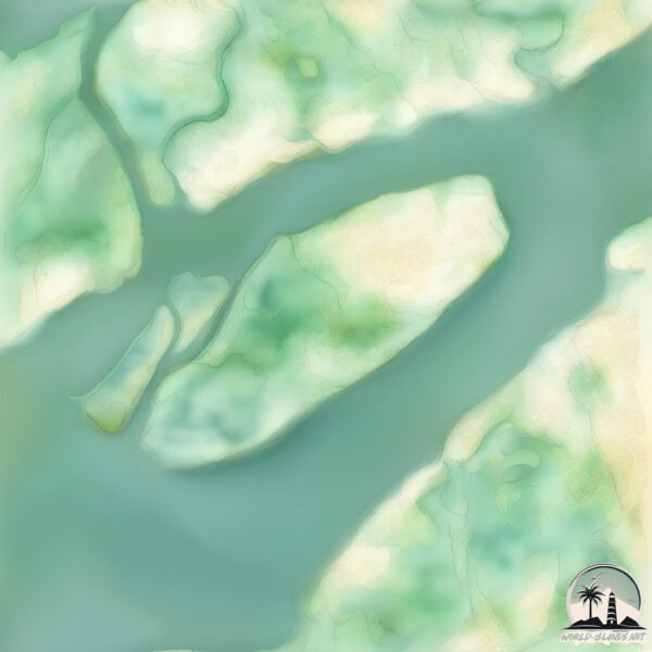
Geography and size of Poutake
Size: 13.1 km²
Coastline: 18 km
Ocean: Atlantic Ocean
Sea: North Atlantic Ocean
Continent: Africa
Poutake is a Medium Island spanning 13 km² with a coastline of 18 km.
Archipel: –
Tectonic Plate: Caribbean – Covering the Caribbean Sea and surrounding regions, this plate is bordered by the North American Plate and the South American Plate. Known for seismic activity, including earthquakes and volcanic eruptions, and features like the Puerto Rico Trench.
The geographic heart of the island is pinpointed at these coordinates:
Latitude: 13.80880196 / Longitude: -16.61971931
Climate and weather of Poutake
Climate Zone: Dry
Climate Details: Hot Semi-Arid (Steppe) Climate
Temperature: Hot
Climate Characteristics: Features hot summers and mild to warm winters. Receives more rainfall than hot deserts but less than tropical savannas, leading to a somewhat more varied landscape.
Topography and nature of Poutake
Timezone: UTC±00:00
Timezone places: Europe/Lisbon
Max. Elevation: 5 m
Mean Elevation: 3 m
Vegetation: Mangrove Forest
Tree Coverage: 66%
The mean elevation is 3 m. The highest elevation on the island reaches approximately 5 meters above sea level. The island is characterized by Plains: Flat, low-lying lands characterized by a maximum elevation of up to 200 meters. On islands, plains are typically coastal lowlands or central flat areas.
Dominating Vegetation: Mangrove Forest
Found in coastal areas and river deltas, these unique wetland ecosystems are adapted to saline conditions and are crucial for coastal protection and biodiversity. Poutake has a tree cover of 66 %.
Vegetation: 5 vegetation zones – Highly Diverse Island
With five different vegetation zones, these islands offer a rich tapestry of ecosystems. The variety could include dense forests, open meadows, wetlands, coastal zones, and more. This level of diversity supports an intricate web of life, with each zone playing a vital role in the overall ecological health and balance of the island.
Infrastructure and Travelling to Poutake
Does the island have a public airport? no.
There is no public and scheduled airport on Poutake. The nearest airport is Banjul International Airport, located 50 km away.
Does the island have a major port? no.
There are no major ports on Poutake. The closest major port is BANJUL, approximately 38 km away.
The mean population of Poutake is 121 per km². Poutake is Moderately Inhabited. The island belongs to Senegal.
Continuing your journey, Gouk is the next notable island, situated merely km away.
5 Best Islands to Visit Near Phuket: Stunning Island Getaways


Senegal is classified as Least developed region: Countries that exhibit the lowest indicators of socioeconomic development, with the lowest Human Development Index ratings. The level of income is Lower middle income.
News – Latest Updates and Headlines from Poutake
Stay informed with the most recent news and important headlines from Poutake. Here’s a roundup of the latest developments.
Please note: The data used here has been primarily extracted from satellite readings. Deviations from exact values may occur, particularly regarding the height of elevations and population density. Land area and coastline measurements refer to average values at mean high tide.