Pulau Ambelau

Welcome to Pulau Ambelau, a Tropical island in the Banda Sea, part of the majestic Pacific Ocean. This guide offers a comprehensive overview of what makes Pulau Ambelau unique – from its geography and climate to its population, infrastructure, and beyond. Dive into the details:
- Geography and Size: Explore the island’s size and location.
- Climate and Weather: Weather patterns and temperature.
- Topography and Nature: Uncover the natural wonders of the island.
- Infrastructure and Travelling: Insights on reaching, staying, and making the most of your visit.
- News and Headlines: Latest News.
Geography and size of Pulau Ambelau
Size: 70.9 km²
Coastline: 40 km
Ocean: Pacific Ocean
Sea: Banda Sea
Continent: Oceania
Pulau Ambelau is a Medium Island spanning 71 km² with a coastline of 40 km.
Archipel: Melanesia – A subregion of Oceania in the southwestern Pacific Ocean, including countries like Fiji, Solomon Islands, and Vanuatu, known for their diverse cultures and languages.
Tectonic Plate: South Bismarck – Located north of New Guinea and east of the North Bismarck Plate, involved in complex interactions with the Pacific Plate, contributing to the region’s seismicity.
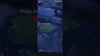
The geographic heart of the island is pinpointed at these coordinates:
Latitude: -3.85781044 / Longitude: 127.19442154
Climate and weather of Pulau Ambelau
Climate Zone: Tropical
Climate Details: Tropical Rainforest Climate
Temperature: Hot
Climate Characteristics: This climate is typified by heavy rainfall throughout the year, high humidity, and consistently high temperatures, leading to lush rainforests and rich biodiversity. Seasonal temperature variations are minimal.
Topography and nature of Pulau Ambelau
Timezone: UTC+09:00
Timezone places: Asia/Tokyo
Max. Elevation: 493 m
Mean Elevation: 195 m
Vegetation: Evergreen Broadleaf Forest
Tree Coverage: 62%
The mean elevation is 195 m. The highest elevation on the island reaches approximately 493 meters above sea level. The island is characterized by Hills: Gently sloping landforms with rounded tops, having a maximum elevation between 200 and 500 meters. Hills contribute to a varied landscape on islands.
Dominating Vegetation: Evergreen Broadleaf Forest
Characterized by dense, lush canopies of broadleaf trees that retain their leaves year-round. These forests are typically found in tropical and subtropical regions and are known for their high biodiversity. Pulau Ambelau has a tree cover of 62 %.
Vegetation: 7 vegetation zones – Very Highly Diverse Island
Islands in this range are ecological powerhouses, showcasing a wide array of vegetation zones. Each zone, from lush rainforests to arid scrublands, coastal mangroves to mountainous regions, contributes to a complex and interdependent ecosystem. These islands are often hotspots of biodiversity, supporting numerous species and intricate ecological processes.
Infrastructure and Travelling to Pulau Ambelau
Does the island have a public airport? no.
There is no public and scheduled airport on Pulau Ambelau. The nearest airport is Pattimura International Airport, located 95 km away.
Does the island have a major port? no.
There are no major ports on Pulau Ambelau. The closest major port is NAMLEA, approximately 60 km away.
The mean population of Pulau Ambelau is 21 per km². Pulau Ambelau is Gently Populated. The island belongs to Indonesia.
Continuing your journey, Pulau Manipa is the next notable island, situated merely km away.
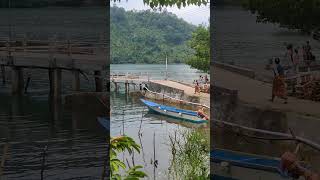
Pemandangan Indah | Pulau Ambalau Maluku


Indonesia is classified as Emerging region: MIKT: Mexico, Indonesia, South Korea, and Turkey – Economies recognized for their development potential and emerging market status. The level of income is Lower middle income.
News – Latest Updates and Headlines from Pulau Ambelau
Stay informed with the most recent news and important headlines from Pulau Ambelau. Here’s a roundup of the latest developments.
Please note: The data used here has been primarily extracted from satellite readings. Deviations from exact values may occur, particularly regarding the height of elevations and population density. Land area and coastline measurements refer to average values at mean high tide.