Welcome to Pulau Labengke, a Tropical island in the Banda Sea, part of the majestic Pacific Ocean. This guide offers a comprehensive overview of what makes Pulau Labengke unique – from its geography and climate to its population, infrastructure, and beyond. Dive into the details:
Geography and size of Pulau Labengke
Size: 43.7 km²
Coastline: 47.8 km
Ocean: Pacific Ocean
Sea: Banda Sea
Continent: Asia
Pulau Labengke is a Medium Island spanning 44 km² with a coastline of 48 km.
Archipel: Greater Sunda Islands – A group of large islands in Southeast Asia, including Borneo, Sumatra, Java, and Sulawesi, known for their rich biodiversity and cultural diversity.
Tectonic Plate: Sunda – Extends across Southeast Asia, encompassing parts of the Sunda Shelf, known for its interaction with the Australian Plate, contributing to volcanic activity in Indonesia.
The geographic heart of the island is pinpointed at these coordinates:
Latitude: -3.45893392 / Longitude: 122.42968177
Climate and weather of Pulau Labengke
Climate Zone: Tropical
Climate Details: Tropical Rainforest Climate
Temperature: Hot
Climate Characteristics: This climate is typified by heavy rainfall throughout the year, high humidity, and consistently high temperatures, leading to lush rainforests and rich biodiversity. Seasonal temperature variations are minimal.
Topography and nature of Pulau Labengke
Timezone: UTC+08:00
Timezone places: Australia/Perth
Max. Elevation: -1 m
Mean Elevation: -1 m
Vegetation: Evergreen Broadleaf Forest
Tree Coverage: 92%
The mean elevation is -1 m. Remarkably, this unique island barely emerges above the sea level, showcasing nature’s fascinating interplay with the ocean. The island is characterized by Plains: Flat, low-lying lands characterized by a maximum elevation of up to 200 meters. On islands, plains are typically coastal lowlands or central flat areas.
Dominating Vegetation: Evergreen Broadleaf Forest
Characterized by dense, lush canopies of broadleaf trees that retain their leaves year-round. These forests are typically found in tropical and subtropical regions and are known for their high biodiversity. Pulau Labengke has a tree cover of 92 %.
Vegetation: 6 vegetation zones – Very Highly Diverse Island
Islands in this range are ecological powerhouses, showcasing a wide array of vegetation zones. Each zone, from lush rainforests to arid scrublands, coastal mangroves to mountainous regions, contributes to a complex and interdependent ecosystem. These islands are often hotspots of biodiversity, supporting numerous species and intricate ecological processes.
Infrastructure and Travelling to Pulau Labengke
Does the island have a public airport? no.
There is no public and scheduled airport on Pulau Labengke. The nearest airport is Haluoleo Airport, located 64 km away.
Does the island have a major port? no.
There are no major ports on Pulau Labengke. The closest major port is KENDARI, approximately 53 km away.
The mean population of Pulau Labengke is 10 per km². Pulau Labengke is Gently Populated. The island belongs to Indonesia.
The name of the island resonates across different cultures and languages. Here is how it is known around the world: Arabic: سولاوسي; German: Sulawesi; Spanish: Célebes; French: Célèbes; Portuguese: Celebes; Russian: Сулавеси; Chinese: 苏拉威西岛
Continuing your journey, Pulau Bahubulu is the next notable island, situated merely km away.
LABENGKI ISLAND, PERJALANAN DARI TELUK KENDARI KE NIRWANA RESORT PULAU LABENGKI - SULAWESI TENGGARA
LABENGKI ISLAND, PERJALANAN DARI TELUK KENDARI KE NIRWANA RESORT.LABENGKI ISLAND, PERJALANAN DARI TELUK KENDARI KE NIRWANA RESORT PULAU LABENGKI - SULAWESI TENGGARA
LABENGKI ISLAND, PERJALANAN DARI TELUK KENDARI KE NIRWANA RESORT.
LABENGKI ISLAND, PERJALANAN DARI TELUK KENDARI KE NIRWANA RESORT.
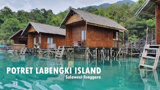
POTRET KEINDAHAN PULAU LABENGKI, SURGA NUSANTARA DI SULAWESI TENGGARA | LABENGKI ISLAND OKTOBER 2020
POTRET KEINDAHAN PULAU LABENGKI, SURGA NUSANTARA DI SULAWESI TENGGARA ...
POTRET KEINDAHAN PULAU LABENGKI, SURGA NUSANTARA DI SULAWESI TENGGARA | LABENGKI ISLAND OKTOBER ...
WISATA || PULAU LABENGKI ISLAND KONAWE UTARA
Pulau Labengki menjadi salah satu gugusan pulau yang secara geografis ...
Pulau Labengki menjadi salah satu gugusan pulau yang secara geografis termasuk ke dalam wilayah Sulawesi Tenggara.
Labengke Island
Kepulauan yang terletak di perbatasan Sulawesi Tenggara dan Sulawesi ...
Kepulauan yang terletak di perbatasan Sulawesi Tenggara dan Sulawesi Tengah. menyajikan pemandangan yang luar biasa, ...
Pulau Labengki
Like n Share : Pulau Labengki, Sulawesi : @arwann.n ••••••••••••• ...
Like n Share : Pulau Labengki, Sulawesi : @arwann.n ••••••••••••• #PlanetIndonesia #exploreindonesia ...
Explore labengki island Tour Package.Sulawesi. indonesia #exploreindonesia #sulawesitenggara
3D2N-4D3N LABENGKI & SOMBORI Tour Itinerary : DAY 1 Kendari – Labengki ...
3D2N-4D3N LABENGKI & SOMBORI Tour Itinerary : DAY 1 Kendari – Labengki - Pasir Panjang Pernerbangan dari Jakarta ke ...
Pulau Labengki & Sombori - Drone 4K -Paradise Islands In Sulawesi Tenggara , Indonesia
AttaHalilintar&@NaisaAlifiaYurizaNAY& @TheHermansyah_A6 &@fujian6590 ...
AttaHalilintar&@NaisaAlifiaYurizaNAY& @TheHermansyah_A6 &@fujian6590 &@ThariqHalilintar &@thenayresmi1340 ...
Labengki island jelmaan Raja ampat papua
Bersama ABDILLAH TOUR & TRAVEL KENDARI '085299429886' Perjalanan anda ...
Bersama ABDILLAH TOUR & TRAVEL KENDARI '085299429886' Perjalanan anda lebih asyik Baik Liburan Bersama Keluarga, ...
Pulau Labengki
Pulau Labengki, Sulawesi Tenggara.
Pulau Labengki, Sulawesi Tenggara.
Keindahan pulau labengki, SULTRA
Pulau labengki salah satu objek wisata di prov. SULTRA..
Pulau labengki salah satu objek wisata di prov. SULTRA..
Mavicpro: Labengki Island From Above
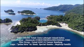
Video DRONE Labengki Island - Sultra Jan 17
Labengki Island di juluki "raja empat" nya Sultra. Laut yang tenang ...
Labengki Island di juluki "raja empat" nya Sultra. Laut yang tenang dan bening, karang yang indah, pasir putih, gugusan ...
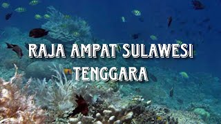
SURGA BAWAH LAUT yang berada di LABENGKI ISLAND - South East Sulawesi Indonesia
Labengki Island It needs car for about 1 hour from the city to sawah ( ...
Labengki Island It needs car for about 1 hour from the city to sawah ( around pudong gala beach or taipa beach or lasolo ) and ...
Trip to Labengki Island - South East Sulawesi 1 day before Ramdhan
This is my trips to southeast sulawesi before ramadhan coming.
This is my trips to southeast sulawesi before ramadhan coming.
Sunrise at Labengki Island
Pulau Labengki, Surga Tersembunyi di Konawe Utara | Nusantara Terkini tvOne
Nusantara Terkini,
https://www.tvOnenews.com - Pulau Labengki, Surga Tersembunyi di Konawe Utara | Nusantara Terkini tvOne ...
Labengki Island
Labengki Island - Southeast Sulawesi.
Labengki Island - Southeast Sulawesi.
Exploring Labengki and Sombori Islands with theTravelMate
Exploring Labengki and Sombori Islands with theTravelMate • Track ...
Exploring Labengki and Sombori Islands with theTravelMate • Track Info: Title: Dreams Artist: Joakim Karud Genre: Hip Hop ...
Exploring Labengki Sombori part 02 - Wet Traveler
Labengki and Sombori, located in South East Sulawesi, are one of the ...
Labengki and Sombori, located in South East Sulawesi, are one of the amazing destination especially for those who love ocean.
Labengki - Sombori Island 2020 | Travel Video
Instagram : kevincaddi Song : Mike Perry - Stay Young (ft. Tessa)
Instagram : kevincaddi Song : Mike Perry - Stay Young (ft. Tessa)
Eksotisme Pulau Labengki, Konawe Utara, Sulawesi Tenggara
Eksotisme Pulau Labengki, Konawe Utara, Sulawesi Tenggara . ...
Day 1 - Labengki Island // Pulau Labengki // #DYNAMICDUOTRAVEL
Labengki Day 1 Amara and Are went on an adventure together, at last! ...
Labengki Day 1 Amara and Are went on an adventure together, at last! It's been long overdue. We have been planning to go ...
SAMBORI - LABENGKI ISLAND
Including Moramo Waterfalls - Southeast Sulawesi , Indonesia.
Including Moramo Waterfalls - Southeast Sulawesi , Indonesia.
You can visit MALDIVES like water in Labengki Island Indonesia 🇮🇩
We visited Labengki Island Indonesia in the second part of my ...
We visited Labengki Island Indonesia in the second part of my INDONESIA Travel Diary visiting some of the most Beautiful Places ...
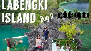
Day 3 - Labengki Island // Pulau Labengki // #DYNAMICDUOTRAVEL
Day 3 - Labengki Island On Day 3, #dynamicduotravel (AMARA & ARA) ...
Day 3 - Labengki Island On Day 3, #dynamicduotravel (AMARA & ARA) explored Labengki area. We of course, still with our 3 ...
Indonesia is classified as Emerging region: MIKT: Mexico, Indonesia, South Korea, and Turkey – Economies recognized for their development potential and emerging market status. The level of income is Lower middle income.
News – Latest Updates and Headlines from Pulau Labengke
Stay informed with the most recent news and important headlines from Pulau Labengke. Here’s a roundup of the latest developments.
Loading...
Please note: The data used here has been primarily extracted from satellite readings. Deviations from exact values may occur, particularly regarding the height of elevations and population density. Land area and coastline measurements refer to average values at mean high tide.