
Rutland Island
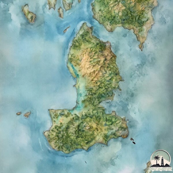
Welcome to Rutland Island, a Tropical island in the Andaman or Burma Sea, part of the majestic Indian Ocean. This guide offers a comprehensive overview of what makes Rutland Island unique – from its geography and climate to its population, infrastructure, and beyond. Dive into the details:
- Geography and Size: Explore the island’s size and location.
- Climate and Weather: Weather patterns and temperature.
- Topography and Nature: Uncover the natural wonders of the island.
- Infrastructure and Travelling: Insights on reaching, staying, and making the most of your visit.
- News and Headlines: Latest News.
Geography and size of Rutland Island
Size: 121.6 km²
Coastline: 71.6 km
Ocean: Indian Ocean
Sea: Andaman or Burma Sea
Continent: Seven seas (open ocean)
Rutland Island is a Large Island spanning 122 km² with a coastline of 72 km.
Archipel: Andaman Islands – Situated in the Bay of Bengal, the Andaman Islands are part of the Indian territory and are known for their picturesque beaches, clear waters, and lush forests. These islands are home to a variety of indigenous tribes and have a rich biodiversity, including unique flora and fauna. The Andamans also have a significant history, notably during the British colonial period.
Tectonic Plate: India – A major tectonic plate that initially moved northward at a rapid pace before colliding with the Eurasian Plate. This collision is responsible for the uplift of the Himalayas and the Tibetan Plateau.
The geographic heart of the island is pinpointed at these coordinates:
Latitude: 11.41819426 / Longitude: 92.64038729
Climate and weather of Rutland Island
Climate Zone: Tropical
Climate Details: Tropical Monsoon Climate
Temperature: Hot
Climate Characteristics: Characterized by heavy rainfall, high humidity, and uniformly high temperatures, but with a distinct short dry season. It features a seasonal reversal of prevailing wind directions.
Topography and nature of Rutland Island
Timezone: UTC+05:30
Timezone places:
Max. Elevation: 329 m
Mean Elevation: 96 m
Vegetation: Evergreen Broadleaf Forest
Tree Coverage: 78%
The mean elevation is 96 m. The highest elevation on the island reaches approximately 329 meters above sea level. The island is characterized by Hills: Gently sloping landforms with rounded tops, having a maximum elevation between 200 and 500 meters. Hills contribute to a varied landscape on islands.
Dominating Vegetation: Evergreen Broadleaf Forest
Characterized by dense, lush canopies of broadleaf trees that retain their leaves year-round. These forests are typically found in tropical and subtropical regions and are known for their high biodiversity. Rutland Island has a tree cover of 78 %.
Vegetation: 10 vegetation zones – Very Highly Diverse Island
Islands in this range are ecological powerhouses, showcasing a wide array of vegetation zones. Each zone, from lush rainforests to arid scrublands, coastal mangroves to mountainous regions, contributes to a complex and interdependent ecosystem. These islands are often hotspots of biodiversity, supporting numerous species and intricate ecological processes.
Infrastructure and Travelling to Rutland Island
Does the island have a public airport? no.
There is no public and scheduled airport on Rutland Island. The nearest airport is Veer Savarkar International Airport / INS Utkrosh, located 17 km away.
Does the island have a major port? no.
There are no major ports on Rutland Island. The closest major port is PORT BLAIR, approximately 22 km away.
The mean population of Rutland Island is 382 per km². Rutland Island is Moderately Inhabited. The island belongs to India.
Continuing your journey, Tarmugli Island is the next notable island, situated merely km away.
India is classified as Emerging region: BRIC: Brazil, Russia, India, and China – Economies noted for their rapid growth and increasing influence on global affairs. The level of income is Lower middle income.
News – Latest Updates and Headlines from Rutland Island
Stay informed with the most recent news and important headlines from Rutland Island. Here’s a roundup of the latest developments.
- Who won in Pinellas County on Election Day 2026? - wtsp.comon 4 November 2026
Who won in Pinellas County on Election Day 2026? wtsp.com
- Tiny Donegal island set for big TV spotlight on More4 - Donegal Dailyon 3 November 2026
Tiny Donegal island set for big TV spotlight on More4 Donegal Daily
- Aiken County 2026 General Election precinct list - Post and Courieron 2 November 2026
Aiken County 2026 General Election precinct list Post and Courier
- 'Islands in the Sky': New comic collection illustrates the real stories of Hurricane Helene survivors - New Hampshire Public Radioon 25 September 2026
'Islands in the Sky': New comic collection illustrates the real stories of Hurricane Helene survivors New Hampshire Public Radio
- Catherine Connolly and husband show their real sides during Irish island visit - Connacht Tribuneon 24 September 2026
Catherine Connolly and husband show their real sides during Irish island visit Connacht Tribune
- Vancouver Island-Central Coast hold tight medal lead in Kelowna BC Summer Games - Abbotsford Newson 25 July 2026
Vancouver Island-Central Coast hold tight medal lead in Kelowna BC Summer Games Abbotsford News
- Rutland: Fury as English county to be wiped off map forever under 'wealth rebalancing' plot - GB Newson 16 July 2026
Rutland: Fury as English county to be wiped off map forever under 'wealth rebalancing' plot GB News
- Spring awakening: wildlife webcams spotlight osprey comeback and puffin joy - The Wildlife Trustson 17 April 2026
Spring awakening: wildlife webcams spotlight osprey comeback and puffin joy The Wildlife Trusts
- Couple’s 100km Easter pilgrimage boosts church’s £200k restoration fund - LincsOnlineon 9 April 2026
Couple’s 100km Easter pilgrimage boosts church’s £200k restoration fund LincsOnline
- Global Birdfair 2026 - BirdLife Internationalon 2 April 2026
Global Birdfair 2026 BirdLife International
Please note: The data used here has been primarily extracted from satellite readings. Deviations from exact values may occur, particularly regarding the height of elevations and population density. Land area and coastline measurements refer to average values at mean high tide.