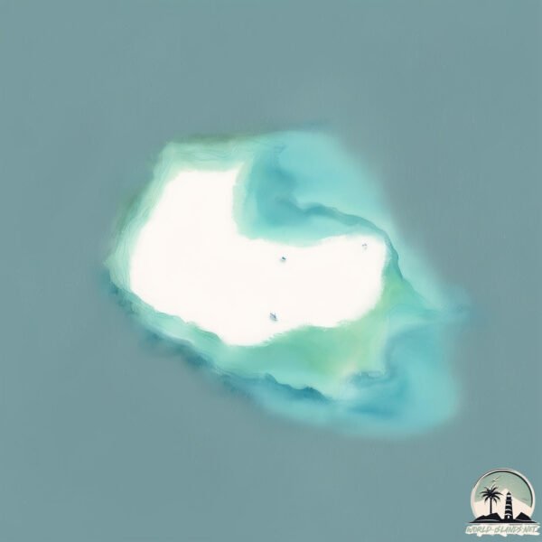
Welcome to Salima, a Dry island in the Red Sea, part of the majestic Indian Ocean. This guide offers a comprehensive overview of what makes Salima unique – from its geography and climate to its population, infrastructure, and beyond. Dive into the details:
Geography and size of Salima
Size: 10.9 km²
Coastline: 15.3 km
Ocean: Indian Ocean
Sea: Red Sea
Continent: Africa
Salima is a Medium Island spanning 11 km² with a coastline of 15 km.
Archipel: Dahlak Archipelago – Located in the Red Sea near Eritrea, known for their historical significance, coral reefs, and diverse marine life.
Tectonic Plate: Arabia – A major tectonic plate covering the Arabian Peninsula and parts of the Middle East. The plate is primarily continental and known for its collision with the Eurasian Plate, leading to the uplift of the Zagros Mountains.
The geographic heart of the island is pinpointed at these coordinates:
Latitude: 15.56867157 / Longitude: 40.79697274
Climate and weather of Salima
Climate Zone: Dry
Climate Details: Hot Deserts Climate
Temperature: Hot
Climate Characteristics: Dominated by extremely hot temperatures, this climate is marked by minimal rainfall and barren landscapes. Nights often experience drastic temperature drops.
Topography and nature of Salima
Timezone: UTC+03:00
Timezone places: Asia/Riyadh
Max. Elevation: 5 m
Mean Elevation: 2 m
Vegetation: Shrubland
Tree Coverage: 1%
The mean elevation is 2 m. The highest elevation on the island reaches approximately 5 meters above sea level. The island is characterized by Plains: Flat, low-lying lands characterized by a maximum elevation of up to 200 meters. On islands, plains are typically coastal lowlands or central flat areas.
Dominating Vegetation: Shrubland
Dominated by shrubs and small bushes, these areas are typical in dry, rocky, or sandy environments, as well as in regions with poor soil fertility. Salima has a tree cover of 1 %.
Vegetation: 7 vegetation zones – Very Highly Diverse Island
Islands in this range are ecological powerhouses, showcasing a wide array of vegetation zones. Each zone, from lush rainforests to arid scrublands, coastal mangroves to mountainous regions, contributes to a complex and interdependent ecosystem. These islands are often hotspots of biodiversity, supporting numerous species and intricate ecological processes.
Infrastructure and Travelling to Salima
Does the island have a public airport? no.
There is no public and scheduled airport on Salima. The nearest airport is Massawa International Airport, located 157 km away.
Does the island have a major port? no.
There are no major ports on Salima. The closest major port is MITSIWA HARBOR, approximately 146 km away.
The mean population of Salima is 5 per km². Salima is Gently Populated. The island belongs to Eritrea.
Continuing your journey, Aucan is the next notable island, situated merely km away.
Em Gele Aei
Provided to YouTube by Ditto Music Em Gele Aei · SALIMA of Kwato Island Rhythm In Paradise Vol.2 ℗ CHM Supersound ...Em Gele Aei
Provided to YouTube by Ditto Music Em Gele Aei · SALIMA of Kwato ...
Provided to YouTube by Ditto Music Em Gele Aei · SALIMA of Kwato Island Rhythm In Paradise Vol.2 ℗ CHM Supersound ...
Sinagu Eo Tamagu
Provided to YouTube by Ditto Music Sinagu Eo Tamagu · SALIMA of Kwato ...
Provided to YouTube by Ditto Music Sinagu Eo Tamagu · SALIMA of Kwato Island Jewel In My Heart Vol.1 ℗ CHM Supersound ...
Jewel In My Heart
Provided to YouTube by Ditto Music Jewel In My Heart · SALIMA of Kwato ...
Provided to YouTube by Ditto Music Jewel In My Heart · SALIMA of Kwato Island Rhythm In Paradise Vol.2 ℗ CHM Supersound ...
CRUISE 5 ON MBENJE ISLAND SALIMA 13 NOVEMBER 2022
A visit to Mbenje Island off Chikombe Beach in Salima. This island is ...
A visit to Mbenje Island off Chikombe Beach in Salima. This island is no ordinary place. In the past, men would report meeting ...
Salima & New Generations - Discover The Islands
DO NOTE: No Infringement Is Intended. For Promotion and Entertainment ...
DO NOTE: No Infringement Is Intended. For Promotion and Entertainment Purposes Only.
Salima - New generation _discover the island (Milne Bay music)
jerusalema original dance video south africa - jerusalema song original video dance
Nituli
Provided to YouTube by Ditto Music Nituli · SALIMA of Kwato Island ...
Provided to YouTube by Ditto Music Nituli · SALIMA of Kwato Island Rhythm In Paradise Vol.2 ℗ CHM Supersound Released on: ...
Salima Lake Malawi | Malawi Africa | Most Beautiful Beach In Africa ⛱️ | Lake Malawi #travel #nature
Salima Lake Malawi Malawi Africa Lake Malawi Most Beautiful Beach In ...
Salima Lake Malawi Malawi Africa Lake Malawi Most Beautiful Beach In Malawi Visiting Places in Africa Africa You Don't See On ...
10 reasons why you should choose Sliema when visiting Malta
If you are visiting Malta and you are wondering where to book, in this ...
If you are visiting Malta and you are wondering where to book, in this video im giving you 10 reasons why you should choose to ...
Nituli
Provided to YouTube by Ditto Music Nituli · SALIMA of Kwato Island ...
Provided to YouTube by Ditto Music Nituli · SALIMA of Kwato Island Jewel In My Heart Vol.1 ℗ CHM Supersound Released on: ...
Love Song
Provided to YouTube by Ditto Music Love Song · SALIMA of Kwato Island ...
Provided to YouTube by Ditto Music Love Song · SALIMA of Kwato Island Rhythm In Paradise Vol.2 ℗ CHM Supersound ...
Listen To The Wind
Provided to YouTube by Ditto Music Listen To The Wind · SALIMA of ...
Provided to YouTube by Ditto Music Listen To The Wind · SALIMA of Kwato Island Rhythm In Paradise Vol.2 ℗ CHM Supersound ...
علاج الكحة في دقيقة.
السعال #السعلة #الكحة #السعلة_الجافة #الكحة_عند_الأطفال الرشح السعال ...
السعال #السعلة #الكحة #السعلة_الجافة #الكحة_عند_الأطفال الرشح السعال الديكي السعال الحاد السعلة الجافة السعلة عند الأطفال.
Hua La dine
Provided to YouTube by Ditto Music Hua La dine · SALIMA of Kwato ...
Provided to YouTube by Ditto Music Hua La dine · SALIMA of Kwato Island Rhythm In Paradise Vol.2 ℗ CHM Supersound ...
Moses Tau - Ei Temarama
I don't own the rights to this music or video!
I don't own the rights to this music or video!
cape verde #sal #capeverde #island #africa #dance #latenight #safe #fun #holidays #melia #meliahotel
Egu Tau Tau
Provided to YouTube by Ditto Music Egu Tau Tau · SALIMA of Kwato ...
Provided to YouTube by Ditto Music Egu Tau Tau · SALIMA of Kwato Island Rhythm In Paradise Vol.2 ℗ CHM Supersound ...
Mbenje Island Chilumba cha Mbenje ati nchamizimu watch it
Sliema – Malta’s Most Lively Seaside Town
Located along Malta's stunning northeastern coast, Sliema is a vibrant ...
Located along Malta's stunning northeastern coast, Sliema is a vibrant seaside town known for its beautiful promenade, historic ...
Eda Adau
Provided to YouTube by Ditto Music Eda Adau · SALIMA of Kwato Island ...
Provided to YouTube by Ditto Music Eda Adau · SALIMA of Kwato Island Jewel In My Heart Vol.1 ℗ CHM Supersound Released ...
5 Best Islands to Visit Near Phuket: Stunning Island Getaways
Discover the 5 best islands to visit near Phuket for a perfect ...
Discover the 5 best islands to visit near Phuket for a perfect getaway! From the stunning Similan Islands to the famous Phi Phi ...
I Investigated the Bermuda Triangle Ship Crashes...
Imagine staying here✨ #greece #travel #shorts #mykonos
Eritrea is classified as Least developed region: Countries that exhibit the lowest indicators of socioeconomic development, with the lowest Human Development Index ratings. The level of income is Low income.
News – Latest Updates and Headlines from Salima
Stay informed with the most recent news and important headlines from Salima. Here’s a roundup of the latest developments.
Loading...
Please note: The data used here has been primarily extracted from satellite readings. Deviations from exact values may occur, particularly regarding the height of elevations and population density. Land area and coastline measurements refer to average values at mean high tide.