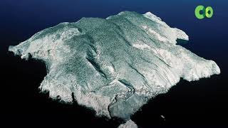
Welcome to San Pedro Martir, a Dry island in the Gulf of California, part of the majestic Pacific Ocean. This guide offers a comprehensive overview of what makes San Pedro Martir unique – from its geography and climate to its population, infrastructure, and beyond. Dive into the details:
Geography and size of San Pedro Martir
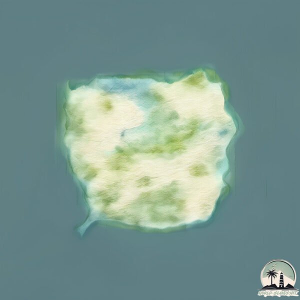
Size: 40.1 km²
Coastline: 29.3 km
Ocean: Pacific Ocean
Sea: Gulf of California
Continent: North America
San Pedro Martir is a Medium Island spanning 40 km² with a coastline of 29 km.
Archipel: –
Tectonic Plate: Pacific – The world’s largest tectonic plate, covering much of the Pacific Ocean, known for the Pacific Ring of Fire with extensive seismic and volcanic activity.
The geographic heart of the island is pinpointed at these coordinates:
Latitude: 28.70187235 / Longitude: -112.57739884
Climate and weather of San Pedro Martir
Climate Zone: Dry
Climate Details: Hot Deserts Climate
Temperature: Hot
Climate Characteristics: Dominated by extremely hot temperatures, this climate is marked by minimal rainfall and barren landscapes. Nights often experience drastic temperature drops.
Topography and nature of San Pedro Martir
Timezone: UTC-07:00
Timezone places: America/Denver
Max. Elevation: 348 m
Mean Elevation: 165 m
Vegetation: Shrubland
Tree Coverage: 24%
The mean elevation is 165 m. The highest elevation on the island reaches approximately 348 meters above sea level. The island is characterized by Hills: Gently sloping landforms with rounded tops, having a maximum elevation between 200 and 500 meters. Hills contribute to a varied landscape on islands.
Dominating Vegetation: Shrubland
Dominated by shrubs and small bushes, these areas are typical in dry, rocky, or sandy environments, as well as in regions with poor soil fertility. San Pedro Martir has a tree cover of 24 %.
Vegetation: 10 vegetation zones – Very Highly Diverse Island
Islands in this range are ecological powerhouses, showcasing a wide array of vegetation zones. Each zone, from lush rainforests to arid scrublands, coastal mangroves to mountainous regions, contributes to a complex and interdependent ecosystem. These islands are often hotspots of biodiversity, supporting numerous species and intricate ecological processes.
Infrastructure and Travelling to San Pedro Martir
Does the island have a public airport? no.
There is no public and scheduled airport on San Pedro Martir. The nearest airport is General Ignacio P. Garcia International Airport, located 171 km away.
Does the island have a major port? no.
There are no major ports on San Pedro Martir. The closest major port is SANTA ROSALIA, approximately 152 km away.
The mean population of San Pedro Martir is 0 per km². San Pedro Martir is Uninhabited. The island belongs to Mexico.
Continuing your journey, San Lorenzo is the next notable island, situated merely km away.
Isla San Pedro Martir - where the sea lions are
Isla San Pedro Martir is a marine biosphere reserve, and one of the remotest rocks in the Sea of Cortez. It's also the home of a ...Isla San Pedro Martir - where the sea lions are
Isla San Pedro Martir is a marine biosphere reserve, and one of the ...
Isla San Pedro Martir is a marine biosphere reserve, and one of the remotest rocks in the Sea of Cortez. It's also the home of a ...
Conociendo Isla San Pedro Mártir
La Isla San Pedro Mártir fue declarada Reserva de la Biosfera en el ...
La Isla San Pedro Mártir fue declarada Reserva de la Biosfera en el año 2002. Esta isla ubicada a 60 km de Bahía de Kino barca ...
San Pedro Mártir Island Top #10 Facts
Isla San Pedro Mártir: una joya del Golfo de California
En medio del Golfo de California se encuentra la Isla San Pedro ...
En medio del Golfo de California se encuentra la Isla San Pedro Mártir, una Reserva de la Biosfera y una de las joyas naturales ...
Isla San Pedro Mártir - Sea of Cortez, México
Inquisitive sea lions, indifferent sea turtle & intimidated octopus ...
Inquisitive sea lions, indifferent sea turtle & intimidated octopus make up the lovely creatures found off Isla San Pedro Mártir.
The sea lions of San Pedro Mártir
Cruising Isla San Pedro Martir on SV Korra
We just spend a few beautiful days at one of the Midriff islands, Isla ...
We just spend a few beautiful days at one of the Midriff islands, Isla San Pedro Martir.
San Carlos TV Video of the Week Isla Martir.mov
In April of 2008 I spent 4 days on isla San Pedro Martir documenting ...
In April of 2008 I spent 4 days on isla San Pedro Martir documenting how wild life biologist were checking to make sure that the ...
La Isla San Pedro Mártir es incluida en la Lista Verde de la UICN
La Reserva de la Biosfera Isla San Pedro Mártir, en Sonora, ya se ...
La Reserva de la Biosfera Isla San Pedro Mártir, en Sonora, ya se encuentra incluida en la Lista Verde de las Áreas Protegidas y ...
Great Outdoors, SEA OF CORTEZ-MIDRIFF ISLANDS CITIZEN SCIENCE, EXPEDITION-SAN PEDRO MARTIR-SEA LION
The Great Outdoors, SEA OF CORTEZ-MIDRIFF ISLANDS CITIZEN SCIENCE, ...
The Great Outdoors, SEA OF CORTEZ-MIDRIFF ISLANDS CITIZEN SCIENCE, DIVING & SNORKELING EXPEDITION, ABOARD ...
¿Conoces la isla de San Pedro Mártir?
Cápsula de la Comisión Nacional de Áreas Naturales Protegidas.
Cápsula de la Comisión Nacional de Áreas Naturales Protegidas.
San Pedro Martir Day 1
Day one diving at San Pedro Martir in the Sea of Cortez on the ...
Day one diving at San Pedro Martir in the Sea of Cortez on the liveaboard Rocio del Mar.
Anchorage at Isla San Pedro Martir
Sea lions, blue footed and brown boobies, tropic birds, two kinds of ...
Sea lions, blue footed and brown boobies, tropic birds, two kinds of grebes. Worth the trip.
Restauración Ecológica de las Islas San Pedro Mártir y Farallón de San Ignacio
More from Isla San Pedro Martir
Video from San Pedro Martir was always going to mean more sea lions! ...
Video from San Pedro Martir was always going to mean more sea lions! Including the big adult bulls with their bulbous foreheads.
Wild sea lion retrieves sand dollar!
A young California Sea Lion at Isla San Pedro Martir returns a sand ...
A young California Sea Lion at Isla San Pedro Martir returns a sand dollar we tossed to her gang! See post: ...
Great Outdoors, SEA OF CORTEZ-MIDRIFF ISLANDS CITIZEN SCIENCE EXPEDITION-SAN PEDRO MARTIR-SEA TURTLE
The Great Outdoors, SEA OF CORTEZ-MIDRIFF ISLANDS CITIZEN SCIENCE, ...
The Great Outdoors, SEA OF CORTEZ-MIDRIFF ISLANDS CITIZEN SCIENCE, DIVING & SNORKELING EXPEDITION, ABOARD ...
San Pedro Martir Day 2 - Sea of Cortez
The second day of SCUBA diving off the island of San Pedro Martir in ...
The second day of SCUBA diving off the island of San Pedro Martir in the Sea of Cortez, one of the most remote islands in the Gulf ...
Ciencia y comunidad en la Isla San Pedro Mártir 🐠
Un ecosistema marino excepcional: bosques de sargazo, mantos de ...
Un ecosistema marino excepcional: bosques de sargazo, mantos de rodolitos, arrecifes de coral negro y una gran diversidad de ...
BIOSFERA ISLA SAN PEDRO MARTIR
Isla San pedro Martir Son Mex
isla san pedro nolasco.
isla san pedro nolasco.
Morena verde en San Pedro Mártir
Una morena verde en Isla San Pedro Mártir, en el Mar de Cortés.
Una morena verde en Isla San Pedro Mártir, en el Mar de Cortés.
Isla San Pedro Martir
Resumen de la desapercibida y gran isla san pedro mártir, datos, ...
Resumen de la desapercibida y gran isla san pedro mártir, datos, curiosidades y mucho más.
Mexico is classified as Emerging region: MIKT: Mexico, Indonesia, South Korea, and Turkey – Economies recognized for their development potential and emerging market status. The level of income is Upper middle income.
News – Latest Updates and Headlines from San Pedro Martir
Stay informed with the most recent news and important headlines from San Pedro Martir. Here’s a roundup of the latest developments.
Loading...
Please note: The data used here has been primarily extracted from satellite readings. Deviations from exact values may occur, particularly regarding the height of elevations and population density. Land area and coastline measurements refer to average values at mean high tide.