Welcome to Schlucht, a Temperate island in the South Pacific Ocean, part of the majestic Pacific Ocean. This guide offers a comprehensive overview of what makes Schlucht unique – from its geography and climate to its population, infrastructure, and beyond. Dive into the details:
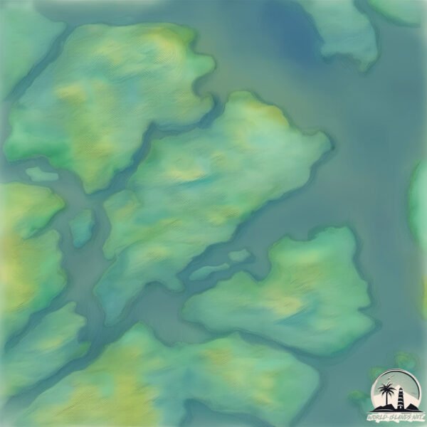
Geography and size of Schlucht
Size: 24 km²
Coastline: 33.9 km
Ocean: Pacific Ocean
Sea: South Pacific Ocean
Continent: South America
Schlucht is a Medium Island spanning 24 km² with a coastline of 34 km.
Archipel: Cordillera Patagónica Insular – A series of islands in the Patagonian region, known for their dramatic landscapes and part of the Andean mountain range.
Tectonic Plate: South America – A major plate covering the South American continent and part of the Atlantic Ocean, known for the Andes mountain range and significant seismic and volcanic activity.
The geographic heart of the island is pinpointed at these coordinates:
Latitude: -48.15952133 / Longitude: -74.79018221
Climate and weather of Schlucht
Climate Zone: Temperate
Climate Details: Subpolar Oceanic Climate
Temperature: Cold Summer
Climate Characteristics: Predominantly cold with cool summers and no dry season. Often found in coastal areas at higher latitudes or on islands.
Topography and nature of Schlucht
Timezone: UTC-04:00
Timezone places: America/La_Paz
Max. Elevation: 354 m
Mean Elevation: 155 m
Vegetation: Evergreen Broadleaf Forest
Tree Coverage: 74%
The mean elevation is 155 m. The highest elevation on the island reaches approximately 354 meters above sea level. The island is characterized by Hills: Gently sloping landforms with rounded tops, having a maximum elevation between 200 and 500 meters. Hills contribute to a varied landscape on islands.
Dominating Vegetation: Evergreen Broadleaf Forest
Characterized by dense, lush canopies of broadleaf trees that retain their leaves year-round. These forests are typically found in tropical and subtropical regions and are known for their high biodiversity. Schlucht has a tree cover of 74 %.
Vegetation: 7 vegetation zones – Very Highly Diverse Island
Islands in this range are ecological powerhouses, showcasing a wide array of vegetation zones. Each zone, from lush rainforests to arid scrublands, coastal mangroves to mountainous regions, contributes to a complex and interdependent ecosystem. These islands are often hotspots of biodiversity, supporting numerous species and intricate ecological processes.
Infrastructure and Travelling to Schlucht
Does the island have a public airport? no.
There is no public and scheduled airport on Schlucht. The nearest airport is El Calafate – Commander Armando Tola International Airport, located 382 km away.
Does the island have a major port? no.
There are no major ports on Schlucht. The closest major port is PUERTO CHACABUCO, approximately 365 km away.
The mean population of Schlucht is 0 per km². Schlucht is Uninhabited. The island belongs to Chile.
Continuing your journey, Schafer is the next notable island, situated merely km away.
CANYON STUÐLAGIL - ISLANDE
Canyon Stuðlagil – Islande Localisation: 65.17516, -15.27079 Stationnement 65.17390, -15.27290 Stuðlafoss 65.16347, ...CANYON STUÐLAGIL - ISLANDE
Canyon Stuðlagil – Islande Localisation: 65.17516, -15.27079 ...
Canyon Stuðlagil – Islande Localisation: 65.17516, -15.27079 Stationnement 65.17390, -15.27290 Stuðlafoss 65.16347, ...
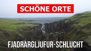
CANYON DE FJAÐRÁRGLJÚFUR - ISLANDE
Canyon de Fjaðrárgljúfur - Islande Localisation: 63.77113, -18.17181 ...
Canyon de Fjaðrárgljúfur - Islande Localisation: 63.77113, -18.17181 Stationnement 63.77129, -18.17189 Début du sentier ...
Eine ganz besondere Schlucht auf Island
asbyrgi #ásbyrgi #schlucht #canyon #iceland #island #icelandadventure ...
asbyrgi #ásbyrgi #schlucht #canyon #iceland #island #icelandadventure #icelandroadtrip #icelandtravel #mydtravel.
BRÚARHLÖÐ CANYON - ISLANDE
Brúarhlöð Canyon - Islande Localisation: 64.26011, -20.22220 ...
Brúarhlöð Canyon - Islande Localisation: 64.26011, -20.22220 Stationnement 64.25922, -20.22508 Belvédère Brúarhlöð est situé ...
The Island of Socotra 🇾🇪
Welcome to Socotra One of the most unique and incredible islands in ...
Welcome to Socotra One of the most unique and incredible islands in the entire world. I was lucky enough to travel here with ...
Fjaðrárgljúfur Schlucht Island #iceland #canyon #drone
300ft Cliff Jump In Nusa Penida
We took a quick boat ride over to Nusa Penida hopped on our scooters ...
We took a quick boat ride over to Nusa Penida hopped on our scooters and drove across the island. We arrived at Kelingking ...
Island in the Sky District at Canyonlands National Park - Moab, Utah #canyonlandsnationalpark
Canyonlands National Park is a worthwhile visit located just outside ...
Canyonlands National Park is a worthwhile visit located just outside Moab, Utah. You can pair it with Dead Horse Point State Park ...
Múlagljúfur Canyon looks like Jurassic World 😍🦕🦖 #shorts #reels #canyon #travel #jurassicworld
Múlagljúfur Canyon along with Hangandifoss and Múlafoss waterfalls are ...
Múlagljúfur Canyon along with Hangandifoss and Múlafoss waterfalls are listed amidst the most scenic attractions of Iceland that ...
One day at Canyonlands National Park (Island in the Sky) | Mesa Arch, Upheaval Dome, & overlooks!
For our first Moab adventure we headed to the Island in the Sky ...
For our first Moab adventure we headed to the Island in the Sky district of Canyonlands National Park, our 4th Utah National Park!
Sky Islands are incredible🏝️🌵🌲🤯 #arizonahiking
Reality check, you can't actually drive 1650 miles in 45 minutes, but ...
Reality check, you can't actually drive 1650 miles in 45 minutes, but the vegetation changes so drastically driving up to Mt.
Fjadrargljufur Canyon - Iceland River | Vantage Journeys 8K
Stunning views of Fjadrargljufur Canyon and River in Iceland. ...
Stunning views of Fjadrargljufur Canyon and River in Iceland. Cinematic nature exploration. Footage from places in 4K. #Shorts ...
ISLAND IN THE SKY Must See Viewpoints | Canyonlands National Park | UTAH
Canyonlands National Park in Utah has unbeatable views that should put ...
Canyonlands National Park in Utah has unbeatable views that should put it on anyone's bucket list. While viewing the canyons ...
Fjadrargljufur-Schlucht in 4k. Island, Fjadrargljufur Canyon zu besuchen
Der Fjadrargljufur-Canyon in Island ist ein atemberaubendes ...
Der Fjadrargljufur-Canyon in Island ist ein atemberaubendes Naturwunder, das bei Touristen und Reisebegeisterten große ...
Island. Eine Schlucht.
Island. Eine Schlucht.
Island. Eine Schlucht.
Iceland Recall - Paul Nelson in der Drachenschlucht, Askja in Island
Askja #Iceland Drekagil ist eine Schlucht im Kraterrand des Vulkans ...
Askja #Iceland Drekagil ist eine Schlucht im Kraterrand des Vulkans Askja in Island. Sie liegt im Gebirgsmassiv Dyngjufjöll etwa ...
Die Fjadrargljufur ( Fjaðrárgljúfur ) Schlucht in Island / Iceland
Fjaðrárgljúfur ist ein Canyon im Südosten von Island, etwa 8 Kilometer ...
Fjaðrárgljúfur ist ein Canyon im Südosten von Island, etwa 8 Kilometer westlich von Kirkjubæjarklaustur gelegen. Er ist über die ...
Island - Fjaðrárgljúfur-Schlucht
TOP 3 Best Minecraft Island Seeds Java & Bedrock 1.21 | Part 2 #seeds #island #minecraft
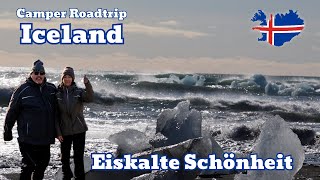
Island Camper Roadtrip – wir besichtigen Stokksnes, Diamond Beach und der schlucht Fjaðrárgljúfur
Island Camper Roadtrip – wir besichtigen Stokksnes, Diamond Beach und ...
Island Camper Roadtrip – wir besichtigen Stokksnes, Diamond Beach und der schlucht Fjaðrárgljúfur Teil 2. In diesem Video ...
Iceland Canyon Drone Flight #travel #canyon #dji #djimini2 #iceland
Eines der Highlights während unsere Island Reise ist der ...
Eines der Highlights während unsere Island Reise ist der Fjaðrárgljúfur. Einfach wunderschön wozu die Natur im Stande ist rein ...
Jurassic Park island in Hawaii 🌺
Jurassic Park Island in Hawaii 🏝️ Spent 8 days in the garden island of ...
Jurassic Park Island in Hawaii 🏝️ Spent 8 days in the garden island of Kauai and had the most magical time (this has become ...
Dettifoss Wasserfall und Ásbyrgi Schlucht | Backpacking Island | VLOG #73
In diesem Vlog besuchen wir den Dettifoss Wasserfall und die Ásbyrgi ...
In diesem Vlog besuchen wir den Dettifoss Wasserfall und die Ásbyrgi Schlucht. Außerdem sehen wir uns an diesem Tag den ...
Die Ásbyrgi Schlucht auf Island
asbyrgi #ásbyrgi #schlucht #canyon #iceland #island #icelandadventure ...
asbyrgi #ásbyrgi #schlucht #canyon #iceland #island #icelandadventure #icelandroadtrip #icelandtravel #mydtravel.
Buck Canyon Overlook | Island in the Sky district | Canyonlands National Park
Aquí te mantengo actualizado qué material de grabación uso para mis ...
Chile is classified as Emerging region: G20: Group of Twenty – Major economies comprising both developed and emerging countries, representing the world’s largest economies. The level of income is Upper middle income.
News – Latest Updates and Headlines from Schlucht
Stay informed with the most recent news and important headlines from Schlucht. Here’s a roundup of the latest developments.
Loading...
Please note: The data used here has been primarily extracted from satellite readings. Deviations from exact values may occur, particularly regarding the height of elevations and population density. Land area and coastline measurements refer to average values at mean high tide.