Sint Eustatius
Welcome to Sint Eustatius, a Tropical island in the Caribbean Sea, part of the majestic Atlantic Ocean. This guide offers a comprehensive overview of what makes Sint Eustatius unique – from its geography and climate to its population, infrastructure, and beyond. Dive into the details:
- Geography and Size: Explore the island’s size and location.
- Climate and Weather: Weather patterns and temperature.
- Topography and Nature: Uncover the natural wonders of the island.
- Infrastructure and Travelling: Insights on reaching, staying, and making the most of your visit.
- News and Headlines: Latest News.
Geography and size of Sint Eustatius
Size: 20.9 km²
Coastline: 22.2 km
Ocean: Atlantic Ocean
Sea: Caribbean Sea
Continent: North America
Sint Eustatius is a Medium Island spanning 21 km² with a coastline of 22 km.
Archipel: Lesser Antilles – A long arc of small islands in the Caribbean Sea, stretching from the Virgin Islands to Trinidad, known for their distinct cultures and tropical landscapes.
Tectonic Plate: Caribbean – Covering the Caribbean Sea and surrounding regions, this plate is bordered by the North American Plate and the South American Plate. Known for seismic activity, including earthquakes and volcanic eruptions, and features like the Puerto Rico Trench.
The geographic heart of the island is pinpointed at these coordinates:
Latitude: 17.49026965 / Longitude: -62.9760308
Climate and weather of Sint Eustatius
Climate Zone: Tropical
Climate Details: Tropical Savanna, Wet
Temperature: Hot
Climate Characteristics: Defined by distinct wet and dry seasons with high temperatures year-round. Pronounced rainfall occurs during the wet season, while the dry season is marked by drought.
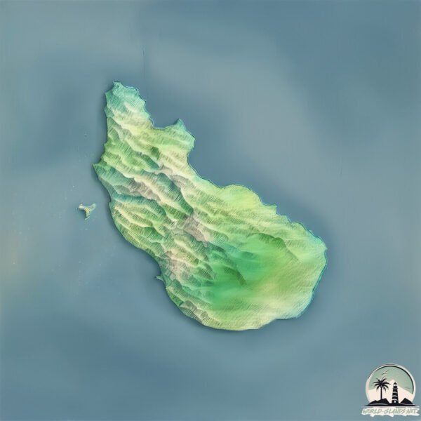
Topography and nature of Sint Eustatius
Timezone: UTC-04:00
Timezone places: America/La_Paz
Max. Elevation: 401 m
Mean Elevation: 116 m
Vegetation: Evergreen Broadleaf Forest
Tree Coverage: 44%
The mean elevation is 116 m. The highest elevation on the island reaches approximately 401 meters above sea level. The island is characterized by Hills: Gently sloping landforms with rounded tops, having a maximum elevation between 200 and 500 meters. Hills contribute to a varied landscape on islands.
Dominating Vegetation: Evergreen Broadleaf Forest
Characterized by dense, lush canopies of broadleaf trees that retain their leaves year-round. These forests are typically found in tropical and subtropical regions and are known for their high biodiversity. Sint Eustatius has a tree cover of 44 %.
Vegetation: 12 vegetation zones – Exceptionally Diverse Island
Islands with more than ten vegetation zones are among the most ecologically rich and varied in the world. These islands are akin to miniature continents, boasting an incredible array of ecosystems. The sheer range of habitats, from high peaks to deep valleys, rainforests to deserts, creates a mosaic of life that is unparalleled. They are crucial for conservation and ecological studies.
Infrastructure and Travelling to Sint Eustatius
Does the island have a public airport? yes.
Sint Eustatius has a public and scheduled airport. The following airports are located on this island: F. D. Roosevelt Airport.
Does the island have a major port? yes.
Sint Eustatius is home to a major port. The following ports are situated on the island: ORANJESTAD.
The mean population of Sint Eustatius is 250 per km². Sint Eustatius is Moderately Inhabited. The island belongs to Netherlands.
The name of the island resonates across different cultures and languages. Here is how it is known around the world: Arabic: سينت أوستاتيوس; Spanish: San Eustaquio; French: Saint-Eustache; Portuguese: Santo Eustáquio; Russian: Синт-Эстатиус; Chinese: 圣尤斯特歇斯
Continuing your journey, St. Kitts is the next notable island, situated merely km away.
ST. EUSTATIUS Travel Guide! (15 BEST things to do on Statia)


Netherlands is classified as Developed region: nonG7: Developed economies outside of the Group of Seven, characterized by high income and advanced economic structures. The level of income is High income: OECD.
News – Latest Updates and Headlines from Sint Eustatius
Stay informed with the most recent news and important headlines from Sint Eustatius. Here’s a roundup of the latest developments.
Please note: The data used here has been primarily extracted from satellite readings. Deviations from exact values may occur, particularly regarding the height of elevations and population density. Land area and coastline measurements refer to average values at mean high tide.