Sri Lanka
Welcome to Sri Lanka, a Tropical island in the Bay of Bengal, part of the majestic Indian Ocean. This guide offers a comprehensive overview of what makes Sri Lanka unique – from its geography and climate to its population, infrastructure, and beyond. Dive into the details:
- Geography and Size: Explore the island’s size and location.
- Climate and Weather: Weather patterns and temperature.
- Topography and Nature: Uncover the natural wonders of the island.
- Infrastructure and Travelling: Insights on reaching, staying, and making the most of your visit.
- News and Headlines: Latest News.
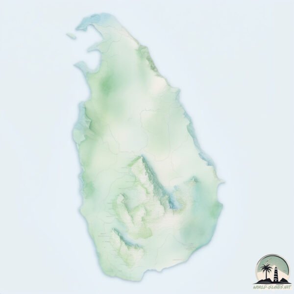
Geography and size of Sri Lanka
Size: 65916 km²
Coastline: 2822 km
Ocean: Indian Ocean
Sea: Bay of Bengal
Continent: Asia
Sri Lanka is a Giant Island spanning 65916 km² with a coastline of 2822 km.
Archipel: –
Tectonic Plate: India – A major tectonic plate that initially moved northward at a rapid pace before colliding with the Eurasian Plate. This collision is responsible for the uplift of the Himalayas and the Tibetan Plateau.
The geographic heart of the island is pinpointed at these coordinates:
Latitude: 7.61238564 / Longitude: 80.70327943
Climate and weather of Sri Lanka
Climate Zone: Tropical
Climate Details: Tropical Savanna, Wet
Temperature: Hot
Climate Characteristics: Defined by distinct wet and dry seasons with high temperatures year-round. Pronounced rainfall occurs during the wet season, while the dry season is marked by drought.
Topography and nature of Sri Lanka
Timezone: UTC+05:30
Timezone places: Asia/Kolkata
Max. Elevation: 2524 m Pidurutalagala
Mean Elevation: 178 m
Vegetation: Evergreen Broadleaf Forest
Tree Coverage: 49%
The mean elevation is 178 m. Dominating the island’s landscape, the majestic “Pidurutalagala” rises as the highest peak, soaring to impressive heights. The island is characterized by Plateau: Elevated flatlands rising sharply above the surrounding area, with a maximum elevation over 500 meters but a mean elevation less than 300 meters, forming unique highland areas on islands.
Dominating Vegetation: Evergreen Broadleaf Forest
Characterized by dense, lush canopies of broadleaf trees that retain their leaves year-round. These forests are typically found in tropical and subtropical regions and are known for their high biodiversity. Sri Lanka has a tree cover of 49 %.
Vegetation: 17 vegetation zones – Exceptionally Diverse Island
Islands with more than ten vegetation zones are among the most ecologically rich and varied in the world. These islands are akin to miniature continents, boasting an incredible array of ecosystems. The sheer range of habitats, from high peaks to deep valleys, rainforests to deserts, creates a mosaic of life that is unparalleled. They are crucial for conservation and ecological studies.
Infrastructure and Travelling to Sri Lanka
Does the island have a public airport? yes.
Sri Lanka has a public and scheduled airport. The following airports are located on this island: Diyawanna Oya Seaplane Base, Hambantota Seaplane Base, Polgolla Reservoir Seaplane Base, Iranamadu Airport, Tissa Tank Waterdrome, Bandaranaike International Colombo Airport, Batticaloa Airport, Colombo Ratmalana Airport, Jaffna International Airport, Koggala Airport, China Bay Airport, Weerawila Airport, Mattala Rajapaksa International Airport.
Does the island have a major port? yes.
Sri Lanka is home to a major port. The following ports are situated on the island: .
The mean population of Sri Lanka is 329 per km². Sri Lanka is Moderately Inhabited. The island belongs to Sri Lanka.
The name of the island resonates across different cultures and languages. Here is how it is known around the world: Arabic: سيريلانكا; German: SRI LANKA; Spanish: SRI LANKA; French: Sri Lanka; Portuguese: Seri Lanca; Russian: Шри-Ланка; Chinese: 斯里兰卡岛
Continuing your journey, Karainagar is the next notable island, situated merely km away.
Sri Lanka - Island of Ceylon


Sri Lanka is classified as Developing region: Regions characterized by lower income levels, with economies in the process of industrialization and modernization. The level of income is Lower middle income.
News – Latest Updates and Headlines from Sri Lanka
Stay informed with the most recent news and important headlines from Sri Lanka. Here’s a roundup of the latest developments.
Social Media Posts about Sri Lanka
Please note: The data used here has been primarily extracted from satellite readings. Deviations from exact values may occur, particularly regarding the height of elevations and population density. Land area and coastline measurements refer to average values at mean high tide.