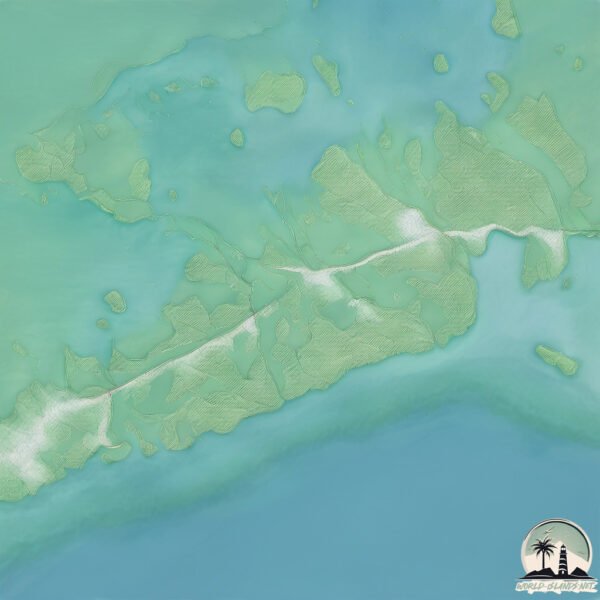
Welcome to Sugarloaf Key, a Tropical island in the Gulf of Mexico, part of the majestic Atlantic Ocean. This guide offers a comprehensive overview of what makes Sugarloaf Key unique – from its geography and climate to its population, infrastructure, and beyond. Dive into the details:
Geography and size of Sugarloaf Key
Size: 45.3 km²
Coastline: 165.5 km
Ocean: Atlantic Ocean
Sea: Gulf of Mexico
Continent: North America
Sugarloaf Key is a Medium Island spanning 45 km² with a coastline of 166 km.
Archipel: –
Tectonic Plate: North America – Covers North America and parts of the Atlantic and Arctic Oceans, characterized by diverse geological features and varying levels of seismic activity.
The geographic heart of the island is pinpointed at these coordinates:
Latitude: 24.63466613 / Longitude: -81.56418384
Climate and weather of Sugarloaf Key
Climate Zone: Tropical
Climate Details: Tropical Savanna, Wet
Temperature: Hot
Climate Characteristics: Defined by distinct wet and dry seasons with high temperatures year-round. Pronounced rainfall occurs during the wet season, while the dry season is marked by drought.
Topography and nature of Sugarloaf Key
Timezone: UTC-05:00
Timezone places: America/New_York
Max. Elevation: 3 m
Mean Elevation: 0 m
Vegetation: Shrubland
Tree Coverage: 62%
The mean elevation is 0 m. The highest elevation on the island reaches approximately 3 meters above sea level. The island is characterized by Plains: Flat, low-lying lands characterized by a maximum elevation of up to 200 meters. On islands, plains are typically coastal lowlands or central flat areas.
Dominating Vegetation: Shrubland
Dominated by shrubs and small bushes, these areas are typical in dry, rocky, or sandy environments, as well as in regions with poor soil fertility. Sugarloaf Key has a tree cover of 62 %.
Vegetation: 11 vegetation zones – Exceptionally Diverse Island
Islands with more than ten vegetation zones are among the most ecologically rich and varied in the world. These islands are akin to miniature continents, boasting an incredible array of ecosystems. The sheer range of habitats, from high peaks to deep valleys, rainforests to deserts, creates a mosaic of life that is unparalleled. They are crucial for conservation and ecological studies.
Infrastructure and Travelling to Sugarloaf Key
Does the island have a public airport? no.
There is no public and scheduled airport on Sugarloaf Key. The nearest airport is Key West International Airport, located 14 km away.
Does the island have a major port? no.
There are no major ports on Sugarloaf Key. The closest major port is KEY WEST, approximately 21 km away.
The mean population of Sugarloaf Key is 58 per km². Sugarloaf Key is Gently Populated. The island belongs to United States of America.
Continuing your journey, Cudjoe Key is the next notable island, situated merely km away.
Why Sugarloaf Key Might Be the BEST Island in the Florida Keys
Looking for the perfect island for you in the Florida Keys? Sugarloaf Key might just be the best-kept secret you've been missing.Why Sugarloaf Key Might Be the BEST Island in the Florida Keys
Looking for the perfect island for you in the Florida Keys? Sugarloaf ...
Looking for the perfect island for you in the Florida Keys? Sugarloaf Key might just be the best-kept secret you've been missing.
Sugarloaf Key/Key West KOA Review - with The DaubSquad
We've been to over 40 KOAs in the past few years. All of them meet the ...
We've been to over 40 KOAs in the past few years. All of them meet the basic requirements of a KOA. Some of them, like Sugarloaf ...
Florida's Table: South of Seven in Sugarloaf Key
We join Chef Paul Kapsalis as he showcases the lifestyle of the Keys ...
We join Chef Paul Kapsalis as he showcases the lifestyle of the Keys through his restaurant, South of Seven in Sugarloaf Key.
AMAZING $5,000,000 Luxury Custom Home in SUGARLOAF KEY
Thinking about moving to Key West or the Florida Keys? You're in the ...
Thinking about moving to Key West or the Florida Keys? You're in the right place. This channel is your go-to source for everything ...
Sugarloaf Key FL, The Local Secret People Are Finally Talking About
Looking for your next adventure in the Florida Keys? Sugarloaf Key ...
Looking for your next adventure in the Florida Keys? Sugarloaf Key might just be the perfect spot. Just 15 minutes from Key West, ...
Sugarloaf Key KOA Resort Tour & Review | Best RV Camping Near Key West
A tour and review of the Sugarloaf Key KOA Resort campground near Key ...
A tour and review of the Sugarloaf Key KOA Resort campground near Key West, Florida. Discover the beauty and convenience of ...
BIGGEST Mistakes to Avoid In The Florida Keys | Watch This Before You Visit The Keys!
Are you planning a Florida Keys Vacation? There is plenty of ...
Are you planning a Florida Keys Vacation? There is plenty of information online about visiting the Florida Keys or exploring Key ...
Sugarloaf keys, Florida, USA 2017.03 aerial video
us80landscape - sugarloaf keys.
us80landscape - sugarloaf keys.
Sugarloaf Key Vacation Destination
One of a Kind Open water & canal front estate located on a quiet ...
One of a Kind Open water & canal front estate located on a quiet street, just 12 miles east of Key West. Relax on the porches or ...
Sugarloaf Key Top #12 Facts
25 Things To Do In Florida Keys and Key West!
We're Olivia and Nathan 25 Things To Do In Florida Keys and Key West! ...
We're Olivia and Nathan 25 Things To Do In Florida Keys and Key West! This is a Florida Keys and Key West travel guide ...
Sugar Loaf Key / Key West KOA Campground Review | Traveling Robert
I share my impressions of our recent stay at the Sugar Loaf Key / Key ...
I share my impressions of our recent stay at the Sugar Loaf Key / Key West KOA Campground, located at mile marker 20 of the ...
Sugarloaf Key reminds us why the world is worth exploring 🌎☀️🛶
Get Up and Go Clear Kayaking (Sugarloaf Key)
Paradise Found Discover the Newest KOA Campground in Sugarloaf Key
Sugarloaf KOA.
Sugarloaf KOA.
Tour of Sugarloaf KOA in the Florida Keys: The Ultimate Camping Destination!
Welcome to Sugarloaf KOA, the premier campground in the Florida Keys. ...
Welcome to Sugarloaf KOA, the premier campground in the Florida Keys. Located on the beautiful island of Sugarloaf Key, this ...
Go To Jumping Bridge Sugarloaf Key Spring Break WHAT TO DO IN KEY WEST
if you want to have a little bit more fun and visit one of the best ...
if you want to have a little bit more fun and visit one of the best locals place in key west check out this video starting from mile ...
This RV Park Feels Like a Private Island | Sugarloaf Key RV Resort and Cottages
Come with us as we explore one of the most incredible RV parks we've ...
Come with us as we explore one of the most incredible RV parks we've ever stayed at- Sugarloaf Key RV Resort and Cottages!
Inside our NEW Luxury 2-Bedroom Cottages Near Key West | Sugarloaf Key RV Resort & Cottages
Join Blue Water's President & CFO, Rafael Correa, as he visits ...
Join Blue Water's President & CFO, Rafael Correa, as he visits Sugarloaf Key RV Resort to officially announce the resort's new ...
16750 Old State Rd, Sugarloaf Key FL. Florida Keys Waterfront ESTATE.
Stunning waterfront Estate! Featuring six Bedrooms and five bathrooms. ...
Stunning waterfront Estate! Featuring six Bedrooms and five bathrooms. Giant Tiki bar, your own private marina style docking, ...
Waterfront Tropical Paradise on Sugarloaf Key for $1,749,000!
Welcome to your very own tropical paradise in highly sought-after ...
Welcome to your very own tropical paradise in highly sought-after Sugarloaf Shores neighborhood! This island gem epitomizes ...
Bungalows at Sugarloaf Key
Secluded bungalows nestled in a 10 acre ocean / beach front paradise. ...
Secluded bungalows nestled in a 10 acre ocean / beach front paradise. This unique property has close to 1000' of private sandy ...
The Lower Florida Keys Ultimate Budget Guide 3 Days in Paradise
This is your ultimate budget guide to the lower and middle Florida ...
This is your ultimate budget guide to the lower and middle Florida Keys. We spend the first day at Bahia Honda state park.
Best RV park in Florida keys, Sugarloaf KOA Campground, and catching a shark
Descriptive video of the KOA campground in the Florida Keys. Sugarloaf ...
Descriptive video of the KOA campground in the Florida Keys. Sugarloaf is one of the last keys. About 15 miles from Key West.
Sea Vista Estate - Sugarloaf Key, Florida
Sea Vista Estate - An ocean front estate located on Sugarloaf Key on ...
Sea Vista Estate - An ocean front estate located on Sugarloaf Key on the Atlantic Ocean in the Florida Keys. 3 well appointed ...
United States of America is classified as Developed region: G7: Group of Seven – Major advanced economies, including Canada, France, Germany, Italy, Japan, the United Kingdom, and the United States. The level of income is High income: OECD.
News – Latest Updates and Headlines from Sugarloaf Key
Stay informed with the most recent news and important headlines from Sugarloaf Key. Here’s a roundup of the latest developments.
Loading...
Please note: The data used here has been primarily extracted from satellite readings. Deviations from exact values may occur, particularly regarding the height of elevations and population density. Land area and coastline measurements refer to average values at mean high tide.