Welcome to Sulabesi, a Tropical island in the Ceram Sea, part of the majestic Pacific Ocean. This guide offers a comprehensive overview of what makes Sulabesi unique – from its geography and climate to its population, infrastructure, and beyond. Dive into the details:
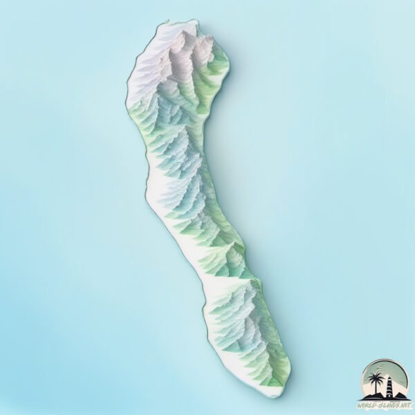
Geography and size of Sulabesi
Size: 536.2 km²
Coastline: 154.4 km
Ocean: Pacific Ocean
Sea: Ceram Sea
Continent: Asia
Sulabesi is a Large Island spanning 536 km² with a coastline of 154 km.
Archipel: Malay Archipelago – The world’s largest archipelago, located between mainland Southeast Asia and Australia, known for its immense biodiversity and cultural diversity.
Tectonic Plate: Molucca Sea – A small tectonic plate in the Molucca Sea in Indonesia, characterized by complex interactions with the surrounding Pacific, Eurasian, and Australian plates. Known for seismic activity and the formation of volcanic arcs.
The geographic heart of the island is pinpointed at these coordinates:
Latitude: -2.21149792 / Longitude: 125.95592591
Climate and weather of Sulabesi
Climate Zone: Tropical
Climate Details: Tropical Rainforest Climate
Temperature: Hot
Climate Characteristics: This climate is typified by heavy rainfall throughout the year, high humidity, and consistently high temperatures, leading to lush rainforests and rich biodiversity. Seasonal temperature variations are minimal.
Topography and nature of Sulabesi
Timezone: UTC+09:00
Timezone places: Asia/Tokyo
Max. Elevation: 555 m
Mean Elevation: 202 m
Vegetation: Evergreen Broadleaf Forest
Tree Coverage: 72%
The mean elevation is 202 m. The highest elevation on the island reaches approximately 555 meters above sea level. The island is characterized by Plateau: Elevated flatlands rising sharply above the surrounding area, with a maximum elevation over 500 meters but a mean elevation less than 300 meters, forming unique highland areas on islands.
Dominating Vegetation: Evergreen Broadleaf Forest
Characterized by dense, lush canopies of broadleaf trees that retain their leaves year-round. These forests are typically found in tropical and subtropical regions and are known for their high biodiversity. Sulabesi has a tree cover of 72 %.
Vegetation: 10 vegetation zones – Very Highly Diverse Island
Islands in this range are ecological powerhouses, showcasing a wide array of vegetation zones. Each zone, from lush rainforests to arid scrublands, coastal mangroves to mountainous regions, contributes to a complex and interdependent ecosystem. These islands are often hotspots of biodiversity, supporting numerous species and intricate ecological processes.
Infrastructure and Travelling to Sulabesi
Does the island have a public airport? no.
There is no public and scheduled airport on Sulabesi. The nearest airport is Pattimura International Airport, located 264 km away.
Does the island have a major port? no.
There are no major ports on Sulabesi. The closest major port is NAMLEA, approximately 145 km away.
The mean population of Sulabesi is 47 per km². Sulabesi is Gently Populated. The island belongs to Indonesia.
The name of the island resonates across different cultures and languages. Here is how it is known around the world: Arabic: جزيرة سانانا; Spanish: Sanana; French: Sanana; Portuguese: Sanana; Russian: Санана; Chinese: 薩納納島
Continuing your journey, Mangole is the next notable island, situated merely km away.
The Beautiful Sula Island. Come and Enjoy it
Kepulauan Sula adalah sebuah Kabupaten di Maluku Utara. Yang mana pemandangan pantai dan bawah lautnya sangat indah.The Beautiful Sula Island. Come and Enjoy it
Kepulauan Sula adalah sebuah Kabupaten di Maluku Utara. Yang mana ...
Kepulauan Sula adalah sebuah Kabupaten di Maluku Utara. Yang mana pemandangan pantai dan bawah lautnya sangat indah.
A quiet port on the island of Sula
Port of Sanana is an port located at the southern boundary of the ...
Port of Sanana is an port located at the southern boundary of the North Moluccas and Moluccas Province Sanana Port is located ...
Jelajah Sulabesi #16 - Jazirah Beach
Video ini di ambil sebelum bulan Ramadhan 1442 Hijriah Salam JS ...
Video ini di ambil sebelum bulan Ramadhan 1442 Hijriah Salam JS Loversss Jumpa lagi di edisi JS Kali ini Yaitu Di Desa Pastina ...
Pulau Sulabesi (Part I) - Mutiara tersembunyi di Ujung Maluku Utara
Pulau Sulabesi adalah salah satu dari 2 pulau besar yang ada di ...
Pulau Sulabesi adalah salah satu dari 2 pulau besar yang ada di Kabupaten Kepulauan Sula, Maluku Utara. Pulau Sulabesi ...
Selamat datang di kepulauan sula, sanana
Selamat datang di kepulauan sula, sanana #pulangkampung ...
Selamat datang di kepulauan sula, sanana #pulangkampung #pulangkampunghalaman #kepulauansula #egilyoisfamily.
PART TERAKHIR DI PULAU SULA SANANA MALUKU UTARA
destinasi wisata pulau Sulabesi, Sanana, Kabupaten Kepulauan Sula, North Molucas
Kota Sanana Kepulauan Sula Maluku Utara #short #foryou #drone
Kota Sanana Kepulauan Sula Provinsi Maluku Utara Indonesia. #sanana ...
Kota Sanana Kepulauan Sula Provinsi Maluku Utara Indonesia. #sanana #kepulauansula #malukuutara #maluku #malukuterkini ...
Jelajah Sulabesi #11 - Wailau Umaga
Edisi JS Kali ini di Pantai Dekat Perbatasan antara Desa Wailau Umaga ...
Edisi JS Kali ini di Pantai Dekat Perbatasan antara Desa Wailau Umaga dan Desa Waiboga JS Kali ini menampilkan indahnya ...
Pantai Waka, Desa Fatkuyon, Kec. Sulabesi Timur, Kab. Kepulauan Sula - Provinsi Maluku Utara
Pantai Tanjung Waka Sanana Kab. Kepulauan Sula #shorts #pantaiwaka #pantaitanjungwaka #kepulauansula
Pantai Waka Sanana Kab. Kepulauan Sula #shorts #pantaiwaka ...
Pantai Waka Sanana Kab. Kepulauan Sula #shorts #pantaiwaka #kepulauansula #pantaitanjungwaka.
PERJALANAN KE PULAU SULA SANANA MALUKU UTARA (Part 2)
SULA ISLAND 🏝️
WELCOME TO HAPPY ISLAND CATANDUANES.
WELCOME TO HAPPY ISLAND CATANDUANES.
WONDERFUL NORTH MALUKU (SULA ISLAND)
Desa Ona, West Sulabesi, Sula Island, North Maluku, Indonesia. Need 2 ...
Desa Ona, West Sulabesi, Sula Island, North Maluku, Indonesia. Need 2 hours from capital city to go to this place. You can go ...
PERJALANAN KE SULA SANANA MALUKU (part 1)
Tanjung Waka (Fatkauyon-Sulabesi) #sanana #waka #kabkepsula #kementerianparekraf
Sebuah destinasi wisata baru di Indonesia Timur Kab Kep Sula Maluku ...
Sebuah destinasi wisata baru di Indonesia Timur Kab Kep Sula Maluku Utara Tanjung Waka dengan segala keindahan baik pasir ...
Tanjung Waka Fatkauyon Kep. Sulabesi Timur, Kab. Kepulauan Sula, Maluku Indonesia
pulau #pulausulabes #pulaumaluku #pantai #fatkauyon #pantaiFatkauyon ...
pulau #pulausulabes #pulaumaluku #pantai #fatkauyon #pantaiFatkauyon #wildlife #natural #paradiseisland #coconutisland ...
Pulau sanana atau pulau Sulabesi provinsi Maluku Utara #pulau #sula #malukuutara #indonesia
Situasi Perjalanan Ternate - Sanana #shorts
Situasi Perjalanan Ternate - Sanana #shorts Dalam video ini adalah ...
Situasi Perjalanan Ternate - Sanana #shorts Dalam video ini adalah gambaran sekilas perjalanan dengan kapal laut dari ...
SANANA - KABUPATEN KEPULAUAN SULA 2025
Ini adalah video drone Perkotaan Sanana di Kabupaten Kepulauan Sula ...
Ini adalah video drone Perkotaan Sanana di Kabupaten Kepulauan Sula yang diambil pada Tahun 2025. Kalau kalian suka ...
Jelajah Sulabesi #2 - PAGAMA
PAGAMA 2020 . . # Jaga Tong Pung Pagama Yang Sumau Hilang . . Video ...
PAGAMA 2020 . . # Jaga Tong Pung Pagama Yang Sumau Hilang . . Video Drone By : Irawan Duwila IG : @irawan_duwila Editor ...
Pelabuhan Sanana Kepulauan Sula Maluku Utara #short #foryou #drone
Pelabuhan Sanana, Kepulauan Sula, Provinsi Maluku Utara, Indonesia. ...
Pelabuhan Sanana, Kepulauan Sula, Provinsi Maluku Utara, Indonesia. #pelabuhan #kapal #kapallaut #kapalferry #sanana ...
pesona wisata di pulau terpencil maluku utara sanana kepulauan sula maluku utara
pesona wisata di pulau terpencil maluku utara sanana kepulauan sula ...
pesona wisata di pulau terpencil maluku utara sanana kepulauan sula maluku utara Social media Facebook ...
pantai soamole, Kecamatan sulabesi tengah, kabupaten kepulauan sula, explore sanana, explore sula
pantai soamole, kecamatan sulabesi tengah, kab kepulauan sula, maluku ...
pantai soamole, kecamatan sulabesi tengah, kab kepulauan sula, maluku utara, (EXPLORE SANANA). JALAN JALAN KE ...
Indonesia is classified as Emerging region: MIKT: Mexico, Indonesia, South Korea, and Turkey – Economies recognized for their development potential and emerging market status. The level of income is Lower middle income.
News – Latest Updates and Headlines from Sulabesi
Stay informed with the most recent news and important headlines from Sulabesi. Here’s a roundup of the latest developments.
Loading...
Please note: The data used here has been primarily extracted from satellite readings. Deviations from exact values may occur, particularly regarding the height of elevations and population density. Land area and coastline measurements refer to average values at mean high tide.