Techong Do
Welcome to Techong Do, a Continental island in the Yellow Sea, part of the majestic Pacific Ocean. This guide offers a comprehensive overview of what makes Techong Do unique – from its geography and climate to its population, infrastructure, and beyond. Dive into the details:
- Geography and Size: Explore the island’s size and location.
- Climate and Weather: Weather patterns and temperature.
- Topography and Nature: Uncover the natural wonders of the island.
- Infrastructure and Travelling: Insights on reaching, staying, and making the most of your visit.
- News and Headlines: Latest News.
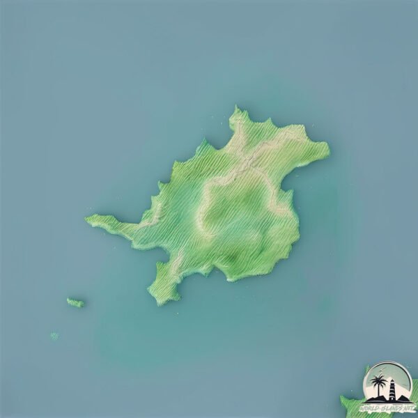
Geography and size of Techong Do
Size: 13.8 km²
Coastline: 26.4 km
Ocean: Pacific Ocean
Sea: Yellow Sea
Continent: Asia
Techong Do is a Medium Island spanning 14 km² with a coastline of 26 km.
Archipel: –
Tectonic Plate: Eurasia – One of the world’s largest tectonic plates, the Eurasian Plate covers a significant portion of Europe and Asia. It’s characterized by diverse geological features, including the Ural Mountains, the European Plain, and the Himalayas formed from its collision with the Indian Plate.
The geographic heart of the island is pinpointed at these coordinates:
Latitude: 37.82508484 / Longitude: 124.70027019
Climate and weather of Techong Do
Climate Zone: Continental
Climate Details: Monsoon-Influenced Hot-Summer Humid Continental Climate
Temperature: Hot Summer
Climate Characteristics: Hot summers with monsoon rains, contrasting with dry, cold winters. Typical of east Asian continental edges.
Topography and nature of Techong Do
Timezone: UTC+09:00
Timezone places: Asia/Tokyo
Max. Elevation: 153 m
Mean Elevation: 68 m
Vegetation: Deciduous Broadleaf Forest
Tree Coverage: 61%
The mean elevation is 68 m. The highest elevation on the island reaches approximately 153 meters above sea level. The island is characterized by Plains: Flat, low-lying lands characterized by a maximum elevation of up to 200 meters. On islands, plains are typically coastal lowlands or central flat areas.
Dominating Vegetation: Deciduous Broadleaf Forest
Composed of broadleaf trees that shed their leaves seasonally. These forests are commonly found in temperate zones and experience distinct seasonal changes. Techong Do has a tree cover of 61 %.
Vegetation: 11 vegetation zones – Exceptionally Diverse Island
Islands with more than ten vegetation zones are among the most ecologically rich and varied in the world. These islands are akin to miniature continents, boasting an incredible array of ecosystems. The sheer range of habitats, from high peaks to deep valleys, rainforests to deserts, creates a mosaic of life that is unparalleled. They are crucial for conservation and ecological studies.
Infrastructure and Travelling to Techong Do
Does the island have a public airport? no.
There is no public and scheduled airport on Techong Do. The nearest airport is Pyongyang Sunan International Airport, located 186 km away.
Does the island have a major port? no.
There are no major ports on Techong Do. The closest major port is HAEJU HANG, approximately 109 km away.
The mean population of Techong Do is 75 per km². Techong Do is Gently Populated. The island belongs to South Korea.
Continuing your journey, Pengyong To is the next notable island, situated merely km away.
(3) "Being an Island": the Buddha's last teaching | by Thich Nhat Hanh, 2009 11 12

South Korea is classified as Emerging region: MIKT: Mexico, Indonesia, South Korea, and Turkey – Economies recognized for their development potential and emerging market status. The level of income is High income: OECD.
News – Latest Updates and Headlines from Techong Do
Stay informed with the most recent news and important headlines from Techong Do. Here’s a roundup of the latest developments.
Please note: The data used here has been primarily extracted from satellite readings. Deviations from exact values may occur, particularly regarding the height of elevations and population density. Land area and coastline measurements refer to average values at mean high tide.